Cadiz Dunes >> Map #24
Cadiz Dunes Wilderness
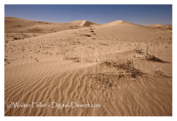
The Cadiz Dunes Wilderness feels like entering a different realm, located in the center of San Bernardino County, merely 40 miles east of Twentynine Palms, California. This expansive 39,740-acre area is focused on the beautiful sand dunes, shaped over time by winds carrying sand from the nearby Cadiz Dry Lake.
Wonders of nature
Cadiz Sand Dunes are not ordinary dunes; they host distinctive plants and animals that have adjusted to the challenging desert environment.Desert Dunes Habitat:
Nature's version of a sandbox, home to a variety of desert creatures. The eastern boundary of the wilderness is indicated by the final 5 miles of Cadiz Road. You can reach the destination with a normal car, but to navigate the southern and northern paths, a four-wheel drive is necessary.The overview of the terrain Geographical Region: Mojave Desert
Ecological region: Sonoran Desert
Ecozone: Cadiz - Vidal Valleys
The region is not only scenic, but also tied to:
The Chemehuevi, Cahuilla, and Vanyume people, also known as the Serrano.
Visiting the Cadiz Dunes Wilderness is a journey, immersing oneself in the beauty of the Mojave and Sonoran deserts' natural wonders and rich cultural past. It is a location where one can immerse oneself in the expansive, sandy terrains and envision the lifestyle of the indigenous people who previously inhabited this area.
SIZE: 39,740 acres
LOCATION: San Bernardino County; 40 miles east of Twentynine Palms, California
NATURAL RESOURCES: The Cadiz Sand Dunes, with their unique flora and fauna, are the focal point of this wilderness. These low dunes were formed from the winds pushing sands from Cadiz Dry Lake, which is outside of the wilderness to the west. Desert dunes habitat.
| GLOSSARY | > dry lake, dunes |
ACCESS: Travel 62 miles east of Twentynine Palms on State Highway 62. Turn north and follow the graveled Cadiz Road for 26 miles. The next 5 miles of the Cadiz Road forms the eastern boundary of the wilderness. Cadiz Road is passable by two-wheel drive vehicles, but the southern and northern bound routes require four-wheel drive vehicles.
Geomorphic Province : Mojave Desert
Ecosection : Sonoran Desert
Ecosubsection : Cadiz - Vidal Valleys
Native Culture : Serrano (Vanyume), Chemehuevi, Cahuilla
Map of Cadiz Dunes Wilderness