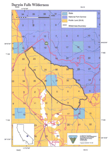
Darwin Falls >> Map #65
Darwin Falls Wilderness
SIZE: 8,600 acresLOCATION: Inyo County; 3 miles north of Darwin, California and 25 miles northeast of Olancha, California
NATURAL RESOURCES: Named after Dr. Darwin French who explored the area in search of the Lost Gunsight Mine. Although named Darwin Falls Wilderness, the falls actually are under the administration of the adjoining Death Valley National Park. The Darwin Plateau and Darwin Hills form the landscape of this wilderness. The plateau, which is cut by numerous shallow depressions and canyons, displays a variety of volcanic rock faces and exposures. Vegetation is typical of a creosote bush scrub community with Joshua tree woodland at higher elevations. Wildlife species include nesting and foraging habitat for prairie falcon.
| GLOSSARY | > canyon, plateau, volcanic, |
ACCESS: Access to this wilderness is via State Highway 190 through Panamint Valley approximately 30 miles east of Olancha and along the road into Darwin or down the Darwin Canyon Road. Travelers should check road conditions before driving.
Geology:
Darwin Canyon/Dike & Sill
China Garden Spring is only one of numerous outflows of groundwater in Darwin Canyon. There is ...Ecology:
Coso - Argus Ranges
... between the Owens Valley and Panamint Valley. It includes the Coso and Argus Ranges and hills and ...