The Bouse Formation:

A Window into the Prehistoric Hydrology of the Lower Colorado River

The Bouse Formation is a geological deposit found in parts of southwestern Arizona, southeastern California, and southern Nevada. Dating back to the Pliocene epoch, approximately 5 to 3 million years ago, this formation consists of fine-grained sediments such as marl, limestone, siltstone, and claystone. It provides crucial insights into the environmental history of the lower Colorado River and its transition from a series of ancient water bodies to the modern river system that defines the region today.

Composition and Depositional Environment

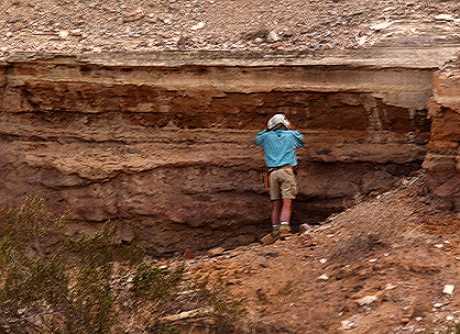
The Bouse Formation primarily comprises calcareous sediments, which indicate deposition in aquatic environments. The presence of marl and limestone suggests that these deposits formed in a setting rich in calcium carbonate, likely influenced by water chemistry changes over time. Interbedded silt and clay layers point to periodic shifts in sediment input, possibly linked to fluctuating water levels or varying sources of sediment.

The nature of the Bouse deposits has led to significant debate over their origin. Some researchers propose that the formation represents a marine incursion when the Gulf of California extended farther inland. This hypothesis is supported by the presence of marine fossils, such as foraminifera, which typically inhabit saltwater environments. However, another widely discussed interpretation suggests that the Bouse Formation was deposited in a series of freshwater to brackish lakes that existed before the modern Colorado River carved its path. In this scenario, the river may have initially flowed into these isolated basins, forming temporary lakes before fully integrating into a continuous drainage system.

Fossil Evidence and Hydrological Implications

One of the most intriguing aspects of the Bouse Formation is its fossil content, which includes both marine and freshwater microfossils. This mix of species suggests that environmental conditions shifted over time, either due to changes in water source or gradual transitions between marine and non-marine settings. The presence of diatoms, ostracods, and other aquatic organisms provides valuable data for reconstructing the region’s paleohydrology.

The Bouse Formation also plays a role in understanding the ancient course of the Colorado River. Some researchers believe that the formation represents the earliest phase of the river’s integration into the Gulf of California. Others argue that before the modern river fully developed, a system of large lakes existed, gradually draining as the river’s course evolved. These interpretations have significant implications for understanding water flow patterns, sediment transport, and landscape evolution in the region.

Connection to Broader Geological History

The study of the Bouse Formation is closely tied to the broader history of the American Southwest, particularly in relation to the Mojave Desert and its ancient lake systems. Similar to the now-extinct Lake Manix, which was part of the Mojave River’s prehistoric flow, the Bouse deposits suggest a period when water played a much more prominent role in shaping the landscape. Understanding these ancient hydrological processes helps geologists piece together the story of how the Southwest transitioned from a wetter, lake-dominated environment to the arid desert we see today.

Conclusion

The Bouse Formation remains a subject of ongoing scientific investigation, as its origins and implications continue to be debated. Whether formed by marine incursions or freshwater lakes, its sediments hold valuable clues about the past hydrology of the lower Colorado River. As researchers uncover more details, the Bouse Formation will remain a critical piece in reconstructing the prehistoric landscape of the region, offering insights into the forces that shaped the modern desert Southwest.

Summary

The Bouse Formation, dating back 5 to 3 million years ago, consists of calcareous sediments found in Arizona, California, and Nevada. It provides key insights into the ancient hydrology of the lower Colorado River. Debate surrounds its origin, with theories of marine incursions or freshwater lakes. Fossil evidence suggests shifting environments, linking it to broader geological changes in the American Southwest.

Damn Yellow Flowers

Desert Gold (Geraea canescens)

Damn Yellow Flowers (DYFs) is a term affectionately (or begrudgingly) used by botanists, naturalists, and desert wanderers to describe the frustratingly abundant and often similar-looking yellow wildflowers that blanket arid regions like the Mojave Desert. These flowers, while beautiful, can be a nightmare to identify—kind of like trying to tell apart identical twins who insist they have wildly different personalities.

The Science Behind DYFs

Desert Dandelion (Malocothryx glabrata)

Despite their casual nickname, DYFs encompass a wide range of plant species, predominantly from the Asteraceae (sunflower) family. This family includes some of the most common desert wildflowers, many of which share characteristics like bright yellow petals, composite flower structures, and a knack for popping up right where you least expect them.

Common DYFs of the Mojave Desert

Brittlebush (Encelia farinosa)

Below are a few of the most frequently encountered DYFs in the Mojave Desert, along with their scientific and common names:

  1. Desert Gold (Geraea canescens) – A tall, wiry-stemmed sunflower lookalike that thrives after rainy winters. It’s often the first to bloom during a superbloom, showing off like that one cousin who always arrives overdressed.
  2. Desert Dandelion (Malacothrix glabrata) – A smaller, daintier yellow flower that resembles a garden dandelion but grows in sandy soils. It’s the floral equivalent of a minimalist, sticking to the basics but still catching your eye.
  3. Golden Suncup (Camissonia brevipes) – A member of the evening primrose family, this plant has smaller yellow flowers that bloom near the ground. It thrives in disturbed soils, much like the houseplants you keep forgetting to water.
  4. Brittlebush (Encelia farinosa) – One of the most easily recognizable DYFs, this shrub produces clusters of yellow daisy-like flowers on long stalks above silvery-green leaves. Imagine a desert plant trying its best to cosplay as a daisy bouquet.
  5. Yellow Cups (Chylismia brevipes) – Similar to golden suncup but with more pronounced petals, this species tends to appear in sandy washes and along roadsides, proving that even wildflowers enjoy people-watching.
  6. Goldfields (Lasthenia californica) – These tiny yellow blooms cover vast expanses of desert terrain, often blending together to create the illusion of a solid golden ground cover—kind of like nature’s way of rolling out the red carpet, but for bees.

Why So Many Yellow Flowers?

Desert Marigold (Baileya multiradiata)

The dominance of yellow in desert wildflowers isn’t just a coincidence. Many desert plants have evolved yellow blooms because it is one of the most visible colors to pollinators, especially bees and butterflies. In an environment where survival depends on successful pollination, standing out is a strategic advantage—basically, these flowers are nature’s version of a flashy billboard.

The Struggles of Identifying DYFs

Bigalow’s Coreopsis (Coreopsis bigelovii)

For amateur botanists and even seasoned professionals, distinguishing between different species of DYFs can be a daunting task. Many species exhibit only minor differences in petal shape, leaf texture, or stem height. Additionally, environmental factors such as soil composition and precipitation levels can influence plant morphology, making identification even trickier. It’s kind of like trying to pick the right brand of mustard—so many choices, all vaguely the same.

Appreciating DYFs Beyond the Frustration

Mojave Sun Cup (Camissonia campestris)

While they may be difficult to differentiate, DYFs are an essential part of the desert ecosystem. They provide nectar and pollen for pollinators, contribute to soil stabilization, and play a role in the desert food chain. Whether viewed as a botanical headache or a seasonal spectacle, these flowers are an undeniable part of the Mojave Desert’s charm.

So the next time you find yourself cursing at a sea of damn yellow flowers, remember that each one has its own niche, history, and role in the desert’s delicate balance. Or just make up a name and move on—chances are, no one will correct you.

Goldfields (Lasthenia californiaca)

The Open Spaces . . .

Those were the days of open-handed hospitality on the Mexican ranches. No introduction was necessary. People came and went on horseback, hung their saddles on pegs and their hats on the floor, and stayed as long as they liked.

Everywhere I stopped I was welcomed. The owner came in from the fields, knocked off work for the day, produced tequila, coffee, cigarettes, and sat down under the porch for a talk. The coffee- pot and bean-pot were always over the fire and in constant requisition. There was no great variety of food at the table, but the meats and vegetables were tastily cooked, and, if there were young girls in the family, there was singing, to the accompaniment of the guitar, during and after the dinner. When it came to retiring for the night, one simply dragged out a rawhide or canvas cot to whatever part of the premises he pleased, spread his blankets, and went to sleep listening to the dogs chasing coyotes.

The hospitality was very simple, whole-hearted, and very gratefully received because of its fine spirit.

John C. Van Dyke

Newberry Springs

Newberry Springs, California, is a small but historically notable town some 20 miles east-southeast of Barstow along the iconic Route 66. Its history is tied to the spread of the railroad, the journey of early migrants, and the precious water resources of the Mojave Desert.

The region initially became well-known when the Southern Pacific Railroad laid railway tracks through the area in 1883. The Watson post office was established at the point of railroad work on February 19 that year and was named for the initial postmaster, Josiah Watson. The post office did not last long, however, closing by July of the same year. The railway, in the meantime, had named its stop Newberry; so when the Watson post office was discontinued, this name de facto became the community’s accepted name. Throughout the years, the region underwent several renaming: in 1899, the post office briefly reopened as Newberry before it was closed afterward; in 1911, it was renamed Wagner in tribute to local resident and grocer Madge Wagner; and in 1919, it was once more renamed as Water, highlighting the great volumes of water—estimates are placed somewhere between 300,000 to 600,000 gallons daily—pumped out of the region for use by the Santa Fe Railroad. Later, in 1967, the name was formally altered to Newberry Springs.

The derivation of “Newberry” is contested. In a local myth, two Newberry brothers lived near the springs, one of whom died in a conflict over water rights. However, a more historically grounded theory suggests the area was named after Dr. J.S. Newberry, a physician on the 1857 expedition of Lt. Joseph C. Ives. Regardless of its actual origins, the name has remained, cementing Newberry Springs’ place in Mojave Desert history.

Newberry Springs has historically been appreciated for its reliable springs, which were important water sources for the early wagon trains and eventually the Santa Fe Railroad. Beyond its transport and water supply historical significance, Newberry Springs has also become well known for artificial ponds, utilized by sporting enthusiasts recreationally, and agricultural promise. The fertile ground in the area makes possible the growing of crops, fruit trees, and cattle ranching, demonstrating versatility beyond its previous transport role.

Another recognizable landmark in Newberry Springs is the Cliff House, situated on the historic Route 66. Though information on the Cliff House is scarce, it serves as a representation of the town’s significance at the peak of American automobile travel. Route 66, nicknamed the “Mother Road,” simplified travel from the Midwest to the West Coast, and Newberry Springs still has vestiges of the period. Vintage motels, service stations, and restaurants still dot the landscape, providing travelers with a glimpse of the roadside culture of the mid-20th century.

Along with its historical significance in transportation and farming, Newberry Springs also holds important archaeological significance. The nearby Newberry Cave is a prominent prehistoric site, containing carefully preserved rock art and artifacts that provide insightful knowledge about the area’s early inhabitants. Additionally, the natural features of the area, including volcanic formations and Troy Lake, contribute to its geological and ecological value.

Newberry Springs is a community that has been defined significantly by its history, geography, and the perpetual issue of water scarcity in the Mojave Desert. Evolving as a railroad stop and developing through the heyday of Route 66 and subsequent developments, this desert town is a fascinating piece of California’s extensive and rich history.

Newberry Springs

Tandem Website Configurations

Mojave Desert Net & Digital-Desert.com

Walter Feller, a retired engineering technician, has spent the past 30 years developing and expanding Digital-Desert.com and MojaveDesert.Net, two extensive resources dedicated to the history, geography, and natural beauty of the Mojave Desert. His work combines research, photography, and storytelling to document the region’s landscapes, historic sites, and ecological significance.

His dedication to preserving and sharing knowledge about the Mojave Desert through these platforms has made him a key figure in desert history documentation.

Introduction

The Mojave Desert is a sprawling, rugged terrain full of history, unusual geology, and varied ecosystems. Two valuable online resources, **MojaveDesert.net** and **Digital-Desert.com**, offer an extensive overview of this interesting region. With coverage ranging from national parks and wilderness areas to ghost towns, historic trails, and natural landmarks, the websites offer detailed guides for adventurers, historians, and nature lovers alike. Suppose you’re interested in desert wildlife and plants, mining history, native cultures, or points of interest. In that case, these websites provide detailed information, interactive maps, and beautiful photographs to make the Mojave tales come alive.

MojaveDesert.net is a comprehensive resource dedicated to the Mojave Desert, offering a variety of information about its geography, history, ecology, and more. The directory tree in the following is not complete but demonstrates While I don’t have access to a complete directory tree of the website, I can provide an overview of its main sections based on available information:

  • Home: Introduction to the Mojave Desert, featuring highlights and recent updates.
  • Geography: Details about the desert’s location, topography, and significant landmarks.
  • Flora and Fauna: Information on the plant and animal species native to the Mojave Desert.
  • History: Insights into the cultural and historical aspects of the region, including indigenous cultures, exploration, and settlement.
  • Ecology: Discussions on the desert’s ecosystems, climate, and environmental concerns.
  • Recreation: Guides and tips for activities such as hiking, camping, and sightseeing in the Mojave Desert.
  • Photo Gallery: A collection of images showcasing the desert’s landscapes, wildlife, and points of interest.
  • Resources: Additional materials like maps, articles, and external links for further exploration.

For a more detailed exploration of the website’s content, I recommend visiting MojaveDesert.net directly.

MojaveDesert.net is a resource covering the Mojave Desert’s geography, history, ecology, flora, fauna, and recreation. It includes sections on landmarks, indigenous cultures, exploration, environmental concerns, hiking, and photography. The site also offers maps, articles, and external resources.

Digital-Desert.COM

Digital-Desert.com is a comprehensive resource dedicated to the Mojave Desert, offering detailed information across various topics:

  • Nature: Explores the desert’s ecology, including its wildlife, plant life, geology, and climate.
  • Parks & Forests: Provides insights into national parks like Death Valley and Joshua Tree, as well as lesser-known state and county parks.
  • Wilderness Areas: Highlights regions preserved in their natural state, free from human impact.
  • Geology & Natural Formations: Discusses the majestic formations and mountain ranges found throughout the Mojave Desert.
  • Points of Interest: Features notable destinations and attractions within the desert.
  • Regional Map Guide: Offers an interactive map for navigating the Mojave Desert.
  • People & History: Delves into the histories of various groups and cultures associated with the Mojave, including influential figures and native cultures.
  • Roads and Trails: Covers historical and contemporary routes, as well as hiking trails and backroads.
  • Ghost Towns & Gold Mines: Examines abandoned communities and the mining history that once thrived in the region.
  • Communities: Profiles current towns and cities within the Mojave Desert.

The website also features sections on the Mojave River, historic roads and trails, craters and lava flows, petroglyphs, dunes, and dry lakes (playas). Additional resources include a blog, weather information, and a glossary.

digital-desert.com

For a more in-depth exploration, visit Digital-Desert.com.

summary

Digital-Desert.com is a comprehensive resource on the Mojave Desert, covering its nature, geology, history, and points of interest. It includes information on national parks, wilderness areas, ghost towns, gold mines, roads, trails, and regional communities. The site also features interactive maps, historical accounts, and details on wildlife, plant life, and natural formations.

description of these two websites combined

Conclusion

MojaveDesert.net and Digital-Desert.com are two extensive online resources dedicated to exploring the Mojave Desert’s rich history, geography, ecology, and cultural significance. Together, they provide a comprehensive look at the region’s national parks, wilderness areas, ghost towns, historic roads, and geological formations. These sites offer in-depth information on the desert’s plant and animal life, environmental concerns, indigenous cultures, mining history, and notable landmarks. Visitors can also find interactive maps, hiking guides, and photography collections that highlight the beauty and complexity of the Mojave Desert.