Report date: February 28, 2026
Executive summary
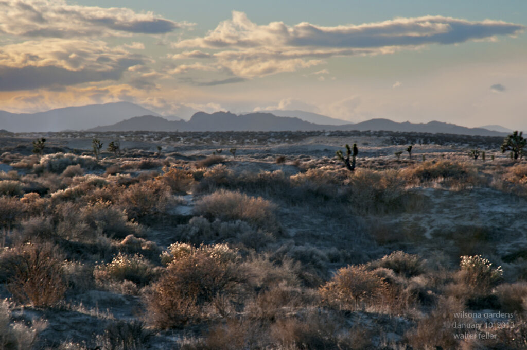
Wilsona Gardens is a small unincorporated community in northeastern Los Angeles County within the Antelope Valley on the western edge of the Mojave Desert. Best-available public gazetteer-style coordinates cluster tightly around 34.6678° N, 117.8256° W, with elevation reported around 2,560–2,570 ft (≈780–783 m), but these values should be treated as an approximate centroid rather than a surveyed boundary point.
The regional climate is strongly arid to semi-arid “high desert,” with cool winters, hot summers, and precipitation concentrated in the cool season. Using 1991–2020 climate normals for nearby Lancaster (William J. Fox Airfield) as a defensible proxy for Wilsona Gardens, mean monthly temperatures range from ~45°F in January to ~82°F in July; annual precipitation normals total ~6.81 inches (173 mm), with ~83% of the annual total falling from November–March.
Vegetation in and around Wilsona Gardens sits at the ecotone between Joshua tree woodland and creosote bush scrub, with additional patch types tied to soil/landform variation: sandy to loamy alluvial fans and washes (supporting creosote and episodic annual wildflowers), granitic pediments/hills (shrub-dominated with sparse cover), and small disturbed parcels/roads that disproportionately favor invasive annual grasses. Nearby Saddleback Butte State Park was established specifically to preserve a Joshua tree woodland in this landscape context, underscoring the local ecological importance and sensitivity of that community.
Key ecological drivers are (i) limited and highly variable water supply (winter storms plus occasional convective summer precipitation), (ii) substrate/soil controls on rooting depth and water holding capacity, (iii) disturbance regimes—especially the modern invasive-grass/fine-fuel pathway that enables uncharacteristic fire in desert shrublands/woodlands, and (iv) expanding land use pressures (parcel development, roads, off-highway vehicle activity, and utility/renewable-energy corridors at a regional scale).
Conservation-relevant species in the broader western Mojave context include the federally threatened Mojave population of the desert tortoise and the state-threatened Mohave ground squirrel; both are sensitive to habitat fragmentation, road mortality, and disturbance. State policy attention is also high for western Joshua tree via the Western Joshua Tree Conservation Act (WJTCA, enacted July 2023), which governs take and permitting.
Geographic setting and administrative boundaries
Assumed place target. This report follows your instruction to treat “Wilsona Gardens” as the community in the Lancaster/High Vista portion of ZIP 93535, rather than similarly named entities elsewhere.
Best-available coordinates and elevation (centroid-style). Multiple independent gazetteer-like sources converge on essentially the same point location:
- Coordinate estimate: 34.6678° N, −117.8256° W (decimal degrees)
- Elevation estimate: ~2,560–2,570 ft (≈780–783 m)
Because these sources behave as “place point” representations (not surveyed boundary vertices), they should be interpreted as an approximate community center suitable for landscape-scale ecological context, not a legal boundary for entitlement, permitting, or parcel decisions.
County and unincorporated status. Los Angeles County contains extensive unincorporated territory governed by the County Board of Supervisors (functionally acting as municipal government for unincorporated areas). A compiled list of unincorporated areas places Wilsona Gardens in Supervisorial District 5 in at least one published local-government reference document.
Relationship to nearby named places and map frameworks. Wilsona Gardens is mapped in the vicinity of Hi Vista and is referenced as appearing on the “Hi Vista” USGS topo quadrangle in at least one place-profile source. These cartographic associations reinforce the appropriateness of analyzing Wilsona Gardens as part of the western Mojave high-desert mosaic rather than the urban Lancaster basin proper.
5 km buffer polygon (for ecological analysis when administrative boundaries are uncertain). Because an authoritative polygon boundary for “Wilsona Gardens” was not retrieved from a primary boundary dataset within the constraints of the sources accessed here, the remainder of this report treats a 5 km radius buffer around the coordinate above as the analysis area of interest (AOI). This is an ecological—not administrative—boundary selection.
- Center (WGS84): (−117.82562, 34.66777)
- Buffer radius: 5,000 m
- Approximate geodesic polygon (WKT; 17-vertex approximation):
POLYGON ((-117.825620 34.712736, -117.805129 34.709460, -117.787627 34.700110, -117.775115 34.686059, -117.769071 34.669837, -117.770117 34.653243, -117.778120 34.638039, -117.792188 34.626827, -117.810667 34.620090, -117.831390 34.618041, -117.852035 34.620584, -117.870518 34.627320, -117.884586 34.638532, -117.892589 34.653736, -117.893635 34.670330, -117.887591 34.686552, -117.875079 34.700603, -117.825620 34.712736))
(Construction method: geodesic forward calculation on a spherical Earth approximation with evenly spaced bearings; intended for communication and reproducibility, not cadastral work.)
Regional physical environment
Physiographic context. Wilsona Gardens lies on the western margin of the Mojave Desert where broad alluvial plains are punctuated by granite buttes and pediments; a nearby reference point is Saddleback Butte, described as a granite mountaintop rising ~1,000 ft above surrounding alluvial plains and reaching 3,651 ft elevation. This terrain creates strong local gradients in exposure, soil depth, and runoff concentration, which drive patchy vegetation patterns despite the region’s overall aridity.
Climate normals (1991–2020) and proxy selection. Station-based 30-year climate normals are the official U.S. reference for “typical” climate conditions and are produced by NOAA National Centers for Environmental Information. For Wilsona Gardens, a practical and transparent approach is to use the nearest long-record station normals that represent the same high-desert air mass and elevation band; LA County compilations report 1991–2020 normals for Lancaster (William J. Fox Airfield) and show close agreement with other regional references.
Temperature regime (1991–2020 normals). Monthly mean temperatures for Lancaster (Fox Field) are ~45°F (Jan), 48°F (Feb), 54°F (Mar), 59°F (Apr), 68°F (May), 76°F (Jun), 82°F (Jul), 81°F (Aug), 74°F (Sep), 63°F (Oct), 51°F (Nov), and 44°F (Dec), with annual mean ~62°F. Average monthly maximums peak near ~98°F in July–August, while average monthly minimums fall to ~30°F in December–January, consistent with strong radiational cooling in dry air and open terrain.
Precipitation seasonality (1991–2020 normals). Normal annual precipitation for the Lancaster (Fox Field) station is 6.81 inches (July–June “rainfall season” framing), with monthly normals strongly weighted to winter: Dec–Feb alone sum to ~4.33 inches (≈64% of annual), and Nov–Mar sum to ~5.66 inches (≈83%). Summer precipitation is typically minimal (e.g., Aug normal ~0.01 in). This seasonality structures the timing and intensity of primary productivity pulses (germination, herbaceous growth, flowering) and constrains perennial recruitment opportunities.
Landforms and soils
Dominant landforms in the 5 km AOI. The key landform template in this sector of the western Mojave is a set of alluvial plains and fans shed from granitic uplands and buttes, plus local washes that convey episodic runoff. Saddleback Butte is explicitly described as a granite feature towering above broad alluvial plains, implying extensive fan and bajada development around nearby uplands. A representative drainage element of this landscape is the region’s washes (ephemeral channels); “Big Rock Wash” is mapped nearby as a GNIS-class feature, illustrating the local importance of episodic flowpaths and shallow alluvial deposition in an otherwise dry matrix.
Why soil series matter ecologically. In arid ecosystems, soil depth to restrictive layers (bedrock, petrocalcic horizons), texture (sand vs loam vs clay), and carbonate content strongly govern (i) infiltration versus runoff, (ii) soil-moisture residence time after storms, (iii) rooting depth for shrubs/trees, and (iv) germination windows for annual wildflowers. NRCS Official Soil Series Descriptions (OSDs) provide standardized, primary descriptions of these properties and the landscape positions where each series occurs.
Likely soil/landform assemblage near Wilsona Gardens (series-level). A fully authoritative soil-map-unit attribution typically requires an AOI query in NRCS Web Soil Survey; the sources accessed here do not include an AOI-specific map output for the Wilsona Gardens centroid. Nevertheless, several OSD soil series are explicitly defined for Mojave Desert settings matching the local landforms and elevations, and they plausibly bracket the range of soil conditions expected within a 5 km AOI:
- Hi Vista series: moderately deep to rock; formed in granitic residuum on hills and rock pediments; mean annual precipitation ~5 inches; vegetation described as native desert shrubs.
- Rosamond series: deep, well-drained, fine-loamy soils on lower margins of alluvial fans between sloping fans and playas; mean annual precipitation ~5 inches.
- Hesperia series: very deep, well-drained soils on alluvial fans, valley plains, and stream terraces; formed in granitic alluvium; native vegetation includes creosote bush in the high desert.
- Lucerne series: arid alluvial fans/terraces in the Mojave Desert; vegetation includes Utah juniper, scattered Joshua tree, annual grasses/forbs, and perennial grasses, indicating a slightly higher-elevation or cooler/moister microclimate subset within the desert fan system.
- Popson series: broad alluvial fans/flood plains in the arid Mojave; mean annual precipitation ~4–5 inches; associated with other fan soils including Hesperia and Rosamond, and explicitly described at elevations ~2,300–2,550 ft—very close to the Wilsona Gardens elevation estimates.
Soils and landforms comparison table
| Soil series (NRCS OSD) | Typical landform position | Key physical traits (ecologically relevant) | Likely vegetation signal in OSD | Relevance to Wilsona Gardens AOI |
|---|---|---|---|---|
| Hi Vista | Hills and granitic rock pediments | Moderately deep to bedrock; residuum from granitic rock; slopes 2–50% | Native desert shrubs | Represents shallow-soil/upland edges and pediment patches likely present near local buttes |
| Rosamond | Lower margins of alluvial fans near playas | Deep, fine-loamy, calcareous; low slopes (0–2%) | Desert range (typical pedon context) | Represents fan-to-basin transition soils that can support creosote scrub and annual forbs on flats |
| Hesperia | Alluvial fans, valley plains, stream terraces | Very deep; coarse-loamy; moderately rapid permeability; semiarid to arid setting | Creosote bush and sparse annuals in high desert settings | Strong candidate for the dominant “developable” fan surfaces around a community centroid |
| Lucerne | Alluvial fans, fan terraces, terraces | Arid; moderately rapid permeability; elevations 2,900–4,800 ft (series range) | Utah juniper, scattered Joshua tree, annuals, perennial grasses | Brackets cooler/moister micro-sites and higher nearby fan/terrace positions; useful for understanding woodland/grassland patches |
| Popson | Broad alluvial fans and flood plains | Arid; mean annual precip 4–5 in; elevations 2,300–2,550 ft (series range) | Fan soils, associated with Hesperia/Rosamond and Mojave settings | Elevation match suggests Popson-like fan soils may occur near the AOI core |
Vegetation and plant communities
Regional vegetation frame. The nearby Saddleback Butte State Park description explicitly frames the local ecosystem as “high-desert Joshua tree woodland” with a “Joshua Tree/Creosote habitat,” and notes that springtime wildflower displays vary strongly by year—an ecological signature of precipitation-driven annual pulses on desert soils. NRCS OSDs for adjacent Mojave soil series independently point to creosote dominance on many fan soils and to Joshua tree presence on certain fan/terrace or woodland-inclined soils (e.g., Lucerne).
Interpreting “percent cover” at two scales. Because a site-specific vegetation survey for Wilsona Gardens (plots/transects) is not included in the accessed primary sources, the report distinguishes between:
(1) Landscape composition (percent of AOI area in broad community types), estimated analytically from landform/soil drivers and verified qualitatively by the documented presence of Joshua tree woodland and creosote habitats in the immediate regional matrix; and
(2) Within-community vegetative cover (e.g., shrub canopy cover), which is not directly estimated here beyond relative structure descriptors due to lack of plot-based measurements in primary sources.
Dominant plant communities expected in the 5 km AOI (with explicit uncertainty). The following landscape composition is presented as a best-estimate range consistent with (i) the explicit Joshua tree woodland/creosote habitat descriptions for the nearest preserved area, (ii) soil-series vegetation hints in NRCS OSDs, and (iii) the strong alluvial-fan template of the western Mojave edge:
- Creosote bush scrub (Larrea tridentata-dominated): ~45–70% of AOI area (highest on broad, low-slope fan surfaces with deep alluvium such as Hesperia/Popson-like settings).
- Joshua tree woodland / Joshua tree–creosote ecotone: ~15–35% (concentrated on slightly higher, cooler terrace/fan positions and near granitic uplands; reinforced by the park established to preserve Joshua tree woodland and by OSDs acknowledging Joshua presence in Mojave fan/terrace soils).
- Mojave desert grassland elements (native perennial bunchgrasses and forbs in shrub interspaces, plus increased annual cover in wet years): ~5–15% as discrete patches or functional components within shrubs/woodland, particularly where soil texture and disturbance history permit grass persistence.
- Annual wildflower fields / ephemeral herbaceous flats: ~2–10% as event-driven, precipitation-dependent expression on favorable soils (notably fan flats and disturbed or sandy microsites), with strong interannual variability.
- Disturbed/developed parcels, roads, and altered ground: ~3–15%, depending on how intensively the 5 km AOI intersects parcel grids and graded surfaces; these areas are ecologically important because they can amplify invasive annual grass establishment and fuel continuity.
Plant community comparison table
| Community type | Diagnostic setting in AOI | Dominant/indicator plants (representative, not exhaustive) | Estimated AOI area share | Primary ecological controls and uncertainties |
|---|---|---|---|---|
| Joshua tree woodland / Joshua tree–creosote ecotone | Higher or cooler fan/terrace positions; near granitic uplands and protected woodland remnants | Joshua tree with creosote in ecotone; woodland emphasis locally documented | 15–35% (range) | Controlled by elevation/microclimate, soil depth/texture, and fire history; quantification is uncertain without mapped vegetation polygons or field plots |
| Creosote bush scrub | Broad alluvial fans/valley plains; deep granitic alluvium soils | Creosote bush indicated as native vegetation on high desert fan soils | 45–70% (range) | Water limitation and soil moisture storage dominate; disturbance can shift understory toward invasives |
| Mojave desert grassland functional component | Interspaces on suitable fan/terrace soils; some higher terrace positions | Perennial grasses and forbs noted in Mojave terrace soils; can form important interspace fuels if invaded by annual bromes | 5–15% (range) | Sensitive to grazing/disturbance and invasive annual grasses; hard to map as discrete “patches” without field data |
| Annual wildflower fields / ephemeral herbaceous expression | Favorable flats and sandy microsites in wet years; spring-bloom response | Wildflower display explicitly noted as variable; driven by winter precipitation pulses | 2–10% (event-driven) | High interannual variability; expression depends on timing and magnitude of winter precipitation and temperature windows |
| Disturbed/developed ground | Parcel grids, graded pads, road shoulders, OHV-impacted surfaces | Often dominated by nonnative annual grasses (e.g., bromes) and ruderal forbs | 3–15% (range) | Disproportionate ecological leverage via invasive grass establishment and fuel continuity; actual extent is boundary/AOI dependent |
Fauna and ecological indicators
Evidence base and approach. Site-specific species inventories for Wilsona Gardens were not present in the accessed primary sources, so this section prioritizes (i) wildlife explicitly reported for the nearest formally managed reference area (Saddleback Butte State Park), and (ii) conservation-status species whose documented ranges include the western Mojave and Los Angeles County portions of that region.
Representative fauna with conservation and indicator value.
- Desert tortoise (Mojave population): Listed as threatened under the U.S. Endangered Species Act (final rule dated April 2, 1990), with threats centered on habitat degradation, fragmentation, disease, and human-caused mortality (including roads and off-highway vehicle impacts). Federal and USGS sources describe the tortoise as an indicator or umbrella species for the ecosystems it occupies, making its habitat needs a useful proxy for overall desert ecosystem integrity.
- Kit fox: Reported as part of the wildlife assemblage at Saddleback Butte State Park; functionally, kit fox presence signals relatively intact desert food webs and prey bases, but local occupancy is sensitive to road density and development pressures.
- Mountain bluebird: Reported at Saddleback Butte State Park; as an open-country insectivore, it reflects seasonal insect availability and habitat openness typical of desert woodland/scrub edges.
- Mohave ground squirrel: Listed as threatened under the California Endangered Species Act and described by state sources as endemic to the western Mojave Desert; the species is explicitly associated with desert scrub communities and Joshua tree woodlands, and CDFW emphasizes renewable energy development pressures as a risk factor. Federal review history documents substantial attention to development-related threats even when federal listing was found not warranted at that time.
Invertebrates (functional role rather than site list). In this ecosystem, the spring annual wildflower pulse implies episodic but high ecological importance for native pollinators and other invertebrates, because short-lived flowering events are synchronized with winter precipitation availability and temperature windows. The strong precipitation seasonality and variable spring wildflower displays described for the local reference area provide the core support for this inference, even though a Wilsona Gardens-specific insect inventory is not sourced here.
Ecological drivers, threats, and conservation context
Water limitation and pulse dynamics. The defining driver is water: annual precipitation is low and concentrated in winter months, producing discrete germination and productivity pulses rather than continuous growth. In the Lancaster-area normals used here, >75% of annual precipitation falls Dec–Mar and ~94% falls Oct–Apr, which tightly constrains recruitment opportunities for long-lived perennials and governs when annual wildflower “events” can occur.
Fire regime transformation via invasive annual grasses. Desert shrublands and Joshua tree woodlands are not structured for frequent fire, yet multiple authoritative sources document how invasive annual grasses increase fine-fuel continuity and drive a grass–fire feedback:
- USGS describes cheatgrass-driven expansion and the positive feedback loop where earlier curing fuels fires and promotes post-fire invasive spread.
- BLM similarly emphasizes that invasive annual grasses create continuous fine fuels, enabling uncharacteristic fire behavior at large scales and leaving native communities more vulnerable to reinvasion.
- USFS fire-effects syntheses report that in the Mojave Desert, red brome codominance (often with Schismus spp.) can allow extensive and rapid fire spread; the western Mojave is explicitly included in the experimental-fire data summarized.
For Wilsona Gardens, the ecological implication is that disturbed surfaces (roadsides, graded pads, firebreak edges) can act as invasion “seedbeds,” converting originally discontinuous desert fuels into a connected matrix capable of carrying fire through shrub and woodland patches.
Land use pressure and fragmentation. Regional conservation analyses for focal species identify a consistent suite of pressure pathways—urban/rural development, renewable energy buildout, road networks, and off-highway vehicle activity—each of which elevates direct mortality risk and fragments habitat. These exact stressors are cited in desert tortoise conservation analyses and in both state and federal discussions of Mohave ground squirrel risk context.
Species- and habitat-specific conservation frameworks. Three governance signals are especially relevant for Wilsona Gardens’ ecological management context:
- Western Joshua Tree Conservation Act (WJTCA): Enacted July 2023, governs take and permitting of western Joshua trees in California and allows permit pathways and potential local delegation under defined conditions.
- Desert tortoise (Mojave population) ESA status: Federally threatened listing (final rule April 2, 1990) with critical habitat and recovery planning history, making habitat disturbance and fragmentation a high-stakes consideration in the broader region.
- Mohave ground squirrel CESA status: State-threatened status and a dedicated conservation strategy framework, with explicit attention to renewable energy development pressures in the western Mojave.
Light pollution and dark-sky policy tools (evidence-limited for AOI membership). Los Angeles County planning open-data services include a “Rural Outdoor Lighting District (Dark Skies)” layer, evidencing that the County uses zoning/planning instruments to manage outdoor lighting in at least some unincorporated areas. Whether Wilsona Gardens falls inside that district boundary was not determined from the sources accessed here, so this is treated as an available management lever rather than a confirmed local condition.
Threats comparison table
| Threat | Mechanism | Evidence base | Expected severity in Wilsona Gardens AOI | Ecological consequences |
|---|---|---|---|---|
| Invasive annual grasses (e.g., bromes) | Increase fine-fuel continuity; outcompete natives; post-fire dominance | USGS cheatgrass fire feedback; BLM invasive fuels; USFS red brome fire spread data including western Mojave | High where disturbance/roads provide establishment niches | Higher probability of uncharacteristic fire; reduced shrub/woodland recovery potential; altered nutrient/water competition |
| Fire (uncharacteristic frequency/intensity) | Fueled by invasives; may kill fire-intolerant woody perennials | Same sources; local Joshua tree woodland value emphasized by protected area mandate | Increasing risk, especially after wet years that grow annual biomass | Conversion of shrub/woodland mosaics toward annual grasslands; loss of Joshua tree recruitment niches |
| Habitat fragmentation (parcels/roads) | Breaks contiguous habitat; increases mortality; facilitates invasives | Desert tortoise threats include habitat loss/degradation and road/OHV impacts; Mohave ground squirrel risk context includes development | Moderate to high depending on parcel density and nearby route networks | Reduced movement corridors; increased predator subsidies; invasive corridors via road shoulders |
| OHV disturbance (regional pathway) | Direct mortality; soil crust disturbance; spread of invasive seeds | Listed among tortoise threat drivers; regional management focus in conservation programs | Potentially high if unmanaged routes concentrate near habitats | Soil destabilization, invasive spread, wildlife disturbance, tortoise mortality risk |
| Climate warming and aridification trends | Shifts suitability and recruitment windows; amplifies drought stress | Joshua tree protection is explicitly framed as climate-relevant state policy | Long-term, high consequence; interacts with fire and development | Reduced recruitment, increased mortality during drought; altered phenology of annual pulses |
Stewardship and management recommendations
Management goal framing (site-scale, AOI-scale). The most defensible objective for Wilsona Gardens is to maintain (or restore where degraded) the structural mosaic of Joshua tree–creosote ecotone, creosote scrub, and wash/fan microhabitats while preventing the disturbance-to-invasive-to-fire pathway from converting that mosaic into an annual-grass fuel bed. This goal is consistent with (i) the protected-area rationale for securing Joshua tree woodland nearby, (ii) the invasive annual grass/fire feedback described by federal land-management and science agencies, and (iii) the conservation requirements implied by sensitive species frameworks in the western Mojave.
Invasive grass prevention as the top near-term intervention.
Prioritize prevention, early detection, and rapid response for invasive annual grasses along disturbance vectors (roadsides, graded pads, utility easements). The rationale is that invasive annual grasses can cure early and create continuous fine fuels that carry fire across landscapes otherwise too discontinuous to burn extensively. Practical, site-scale tactics include: limiting new soil disturbance, requiring weed-free fill/materials, staging equipment on already disturbed ground, and suppressing invasive seed set in targeted strips before peak curing.
Fire risk reduction tailored to desert ecology.
Because desert shrublands/woodlands can be highly vulnerable to fire once invasive fuels connect patches, prioritize fuel continuity interruption rather than broad brush removal. Use narrow, strategically placed breaks on already disturbed alignments (roads, parcel edges) and manage fine fuels (annual grasses) rather than removing native shrubs that stabilize soils and provide habitat. This is consistent with the Mojave-specific observation that annual grass codominance can enable rapid fire spread in desert systems.
Joshua tree governance compliance and conservation design.
Any action involving western Joshua trees should be planned under WJTCA permitting logic (including incidental take pathways and mitigation/fee options where applicable). A conservative stewardship posture is to treat Joshua trees on-site as protected biological assets and to design development footprints and access routes to avoid impacts, consistent with the statute’s take prohibitions unless authorized.
Habitat-friendly parcel and roadway practices.
Where development is occurring or planned, prioritize clustered footprints, minimized new road cuts, and dark-sky compatible lighting where feasible, using the County’s demonstrated availability of outdoor lighting district tools as a policy model even if AOI inclusion is uncertain. Fragmentation pathways are repeatedly identified as core threats to sensitive desert fauna, particularly for the desert tortoise and for regionally endemic species like Mohave ground squirrel.
Wildlife-sensitive operations and education.
In areas likely to support high-value species habitat (especially broadly suitable desert scrub and Joshua woodland), reduce night driving on unpaved roads, limit free-roaming pets, and prioritize signage/education around sensitive species and invasive-seed hygiene. These measures align with the human-mortality and habitat-degradation pathways documented for desert tortoise and emphasized in western Mojave conservation initiatives.
Seasonal ecological pulse model (Mermaid)
The following conceptual pulse timeline links the observed climate seasonality (winter-dominant precipitation, hot dry summers) to predictable ecological responses in Mojave scrub/woodland systems.
flowchart TB
A[Oct–Apr: Storm season dominates annual precipitation] –>
B[Soil moisture recharge on fans, washes, shallow soils] B –>
C[Nov–Feb: Germination window opens for annuals in wet years] C –>
D[Feb–Apr: Peak flowering pulse (wildflowers vary strongly by year)] D –>
E[Mar–May: Seed set and seedbank replenishment] E –>
F[May–Jun: Rapid drying; annual senescence] F –>
G[Jun–Sep: Hot/dry summer; drought stress; low primary productivity] G –> H[Late summer: occasional convective storms (usually minor totals)] H –> I[Patchy late-season germination possible; generally limited] I –>
A F –>
J[If invasive annual grasses present: continuous fine fuels] J –>
K[Higher probability of uncharacteristic wildfire spread] K –>
L[Post-fire: invasive grass dominance risk increases] L –>
J