-.-
The Ancestral Mojave River
The ancestral Mojave River was a major desert drainage system in what is now the Mojave Desert of southern California. Its watershed covers approximately 3,670 square miles (9,500 square kilometers), making it the largest integrated fluvial system in the region. Unlike the modern Mojave River, which is intermittent, the ancestral system supported a chain of perennial lakes and a more continuous flow during wetter climatic periods.
Geographic Structure
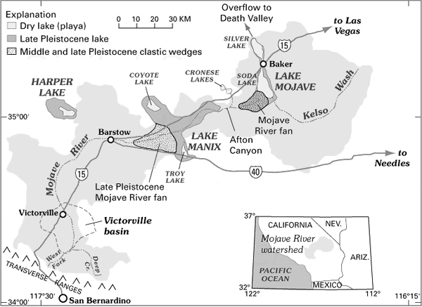
The system originated in the San Bernardino Mountains, where precipitation and snowmelt fed an upper watershed composed of multiple tributaries. Principal headwater sources included Deep Creek and the West Fork, along with smaller tributaries such as Miller Creek, Sawpit Canyon, and Cleghorn Creek. These streams converged in the upper basin near Summit Valley.At the confluence, the combined flow entered the Victorville Basin, passing through the Upper Narrows and continuing northwest toward Helendale. From there, the river expanded into a series of downstream basins and lake systems, including Harper Lake and the extensive Lake Manix system, which also encompassed Troy Lake and Coyote Lake.
Beyond these basins, the river cut through Afton Canyon, one of the most significant bedrock constrictions along its course, before spreading across the Mojave River Fan. The system then extended into the Cronese Basin, divided into East and West Cronese lakes, and continued toward the terminal basins of Soda Lake and Silver Lake near present-day Baker.
At its greatest extent, overflow from these basins may have reached Lake Mojave and, during exceptional hydrologic conditions, continued northward toward Death Valley.
Hydrologic Character
The ancestral Mojave River differed fundamentally from its modern counterpart. Sustained by cooler, wetter climatic conditions during the Pleistocene, it maintained perennial or near-perennial flow. The river functioned as a linked basin system, in which water periodically filled, overflowed, and connected a sequence of lakes across the desert floor. This produced a dynamic hydrologic network sensitive to climatic oscillations, particularly glacial-interglacial cycles.Geologic Development
The evolution of the ancestral Mojave River is closely tied to tectonic activity in southern California.Between approximately 11 and 10 million years ago, the region sloped westward toward the Pacific Ocean, and drainage followed that slope. Between 8 and 7.6 million years ago, the formation of the ancestral Transverse Ranges along the San Gabriel fault began altering regional topography.
By about 3.5 million years ago, uplift of the San Gabriel Mountains blocked westward drainage, creating marshlands and initiating internal basin development. During this period, ancestral Deep Creek emerged from the rising San Bernardino Mountains.
Between 2.5 and 2 million years ago, continued uplift along the San Andreas fault further elevated the San Bernardino Range, reversing the regional drainage direction and establishing an east- and north-flowing system.
From 1.5 to 1 million years ago, additional faulting to the north and east refined basin structure and drainage pathways.
By approximately 500,000 years ago, stable perennial lakes such as Harper Lake and Lake Manix had formed. Between 70,000 and 80,000 years ago, the Mojave River developed a well-defined, incised channel, marking the emergence of a recognizable fluvial course.
Interpretation and Significance
The ancestral Mojave River illustrates the combined influence of tectonics and climate on desert hydrology. Its evolution reflects major structural changes associated with the San Andreas fault system, as well as climatic fluctuations that controlled water availability and lake formation.This system is often described as "upside-down and backwards" because, in contrast to typical river systems, much of its flow is subsurface today, and its historical drainage direction was reversed by tectonic uplift. The remnants of its former lakes, preserved as dry playas, provide important evidence for reconstructing paleoenvironments in the Mojave Desert.
The watershed of the Mojave River = approx. 3670 sq miles (9500 sq km)
Contents
-
San Bernardino Mountains
Upper Watershed
-
East Fork
West Fork
Confluence
-
A flowing together of two or more streams, or a point at which streams combine
Victorville Basin
Upper Narrows
Helendale
Harper Lake
Lake Manix
Afton Canyon
Mojave River Fan
Cronese Basin
Lake Mojave
Salt Spring & the end of the Mojave
Overflow to Death Valley
Map Reference:
Enzel, Wells, & Lancaster - Paleoenvironments and Paleohydrology of the Mojave and Southern Great Basin Deserts
USGS Mojave River Maps
Mojave River Drainage Ecology
Dry Lakes
This model was developed from a presentation titled 'The Ancestral Mojave River' By Professor Norman Meek to show what the Mojave River and its network of lakes may have looked like before the arrival of man--As a simple aid to visualize the river and its lake system from a crude geological standpoint, and not a depiction of the paleoenvironment including the flora and fauna of those times.Programs to modify these images and produce effects such as lakes with water and removal of any manmade objects from the image were used as necessary. Unaltered photos have been used when possible.
Chronology of the Ancestral Mojave River
-
11-10 Ma. (million years ago)
The region sloped toward the Pacific Ocean
8-7.6 Ma.
Birth of ancestral Transverse Ranges (San Gabriel fault)
3.5 Ma.
San Gabriel Mountains rise blocking the slope to the ocean and forming marshlands. Ancestral Deep Creek coming out of the San Bernardino Range begins to appear.
2.5-2 Ma.
Continued rise of the San Bernardino Range along the San Andreas fault reverse the regional drainage direction.
1.5-1 Ma.
The development of faults further to the north and east.
.5 Ma.
Appearance of perennial lakes Harper and Manix
70-80 ka. (thousand years ago)
Ancestral Mojave River develops as an incised channel with a course.
Also see: