Ridgecrest, Ca
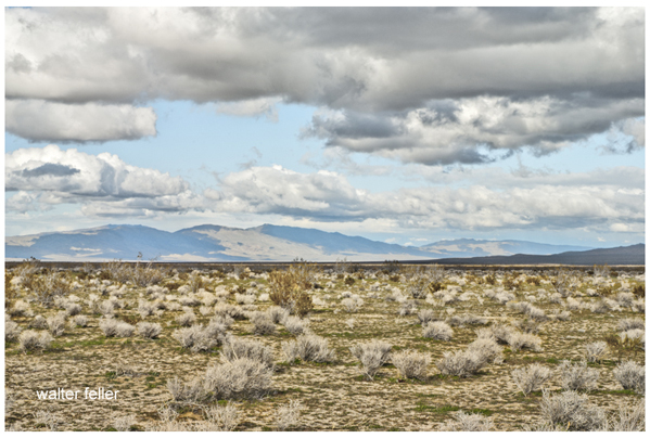
El Paso Mountains
El Paso Mountains, Fremont Valley, Garlock Fault
Area Description:
The roads and trails of the El Paso Mountains will lead you into a region known for its dazzling multi-hued canyons, historic mining areas and primitive desert landscapes.
Highways
Ecosubsections
Searles Valley - Owlshead Mountains
This subsection includes the Slate Range, El Paso Mountains, Quail Mountains, Owlshead Mountains, southern ends of ...High Desert Plains & Hills
This subsection consists of the western Mojave Desert, which is mostly alluvial plain and pediment, with relatively ...Geomorphology
Mojave Desert Province
The Mojave is a broad interior region of isolated mountain ranges separated by expanses of desert plains. ...Basin and Range Province
The Basin and Range is the westernmost part of the Great Basin. The province is characterized by interior drainage with lakes and playas, and ...Garlock Fault
The Garlock Fault is the defining fault between the Mojave Desert and ...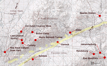
Burro Schmidt Tunnel
William "Burro" Schmidt spent 38 years digging through Copper Mountain in the El Paso range. ...Burro Schmidt Cabin
His love for Aunt Jemima Pancakes is evidenced by the numerous boxes nailed to ...Goler Gulch
John Goller was one of the Lost '49ers who had seen gold in one of the canyons on his way ...Garlock
At first Garlock was known as El Paso City or Cow Wells interchangeably. The little town provided ...Red Rock Canyon
Red Rock Canyon State Park features scenic desert cliffs, buttes and spectacular ...Last Chance Canyon
Manly and Rogers on their heroic walk to save a party of lost 49er's made their way through this rugged ...Cudahy Ghost Camp
The 700 foot high pumicite outcropping in El Paso Mountains was between ...Holly Mine
Cleanser mine located in the El Paso range.Bickel Camp
Walt Bickel's gold camp ...El Paso Mountains Wilderness
Numerous reddish-colored buttes and dark, uplifted volcanic mesas dissected by narrow canyons distinguish this ...El Paso Mountains Mining District
The first recorded mining activity in the El Paso Mountains predates the Sageland discoveries by a few years, but the majority of ...El Paso Mountains
Location. The El Paso Mountains are in northeastern Kern County, some 10 miles northwest and north of Randsburg. A series of dry placer "diggings" lies between Redrock Canyon on the southwest and the Summit "diggings" to the northeast. The district includes the areas known as the Goler, Garlock and Searles districts.
History. Gold was discovered in Goler Canyon in 1893, and dry washing camps soon sprang up at Last Chance, Red Rock, Jawbone Canyon and Summit Diggings. Mining activity declined by 1900, but a number of operations were reactivated during the 1930s, and since World War II, there has been minor prospecting. In these dry placer districts, the easily recoverable gold was mined at one locality in a few months to a year or two, and the miners moved on to other areas.
Ore Deposits. Auriferous sands and gravels occur in benches above the present canyons and on bedrock in the washes and canyons themselves. Much of the gold is believed by Hulin (1934) to have been derived from the erosion and reworking of the basal conglomerate of the Ricardo Formation (lower Pliocene), which is e.xtensive in this region. The gold particles are round and show evidence of considerable abrasion. The gold is mostly fine, although nuggets of up to several ounces have been recovered. Some narrow gold-quartz veins occur in granite and schist.
BULLETIN 193
California Division of Mines and Geology
Sacramento, California, 1970