Indian Wells Valley & greater Ridgecrest area
Indian Wells Valley Groundwater Basin is located east of the southern Sierra Nevada Range. Average annual precipitation in the valley is about 4 to 6 inches. Surface elevation in the central Indian Wells Valley ranges from 2,150 to 2,400 feet above sea level. The basin is a closed, internally drained basin bounded by outcrop of igneous and metamorphic basement rock complexes. The Sierra Nevada Range bounds the basin on the west, the Coso Range on the north, the Argus Range on the east, and the El Paso Mountains on the south. China Lake, a perennial lake, is situated in the central northeastern valley.source - South Lahontan Hydrologic Region California’s Groundwater Indian Wells Valley Groundwater Basin Bulletin 118
Also see:
Ridgecrest
Elevation: 2,290 ft. 2000 Census: 27,772 ...Walker Pass
In 1834 the pass was used as a route through the Sierra by Joseph R. Walker, an experienced mountain man, scout and a ...Robbers Roost
Outlaws were known to use the formation as a lookout for stagecoaches that were moving ...Litte Petroglyph Canyon
The Coso Rock Art District, a National Historic Landmark deep in the U.S. Navy's testing station at China Lake, contains one of America's ...Death Valley's Lost 49er's
... turned south and climbed a small pass into Searles Lake Valley before making their way into Indian Wells Valley near the present day city of Ridgecrest. ...
High Desert Plains and Hills: Mojave Desert Ecological Subsections
It includes Indian Wells Valley north of the Garlock Fault; otherwise it is between the Garlock Fault on the north and northwest, the San Andreas Fault on ...
Owens Valley: Mojave Desert Ecological Subsections
Owens Lake overflowed through Rose Valley to Indian Wells Valley during the Pleistocene, but not recently. Owens Lake is no longer a lake, although it has ...
Fossil Falls - Mojave Desert
In these times the Owens River flowed south out of Owens Lake into the Indian Wells Valley. Volcanic eruptions from the Coso Range changed the river's ...
Ashford Mill & Shoreline Butte
It was probably connected to the Owens River via the Panamint, Searles and Indian Wells Valley in the Illinoisan but probably not in the Wisconsin Ice ages ...
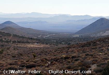
Indian Wells Valley as observed from Walker Pass