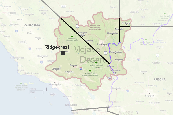
Ridgecrest
Elevation: 2,290 ft.
The Indian Wells Valley area that is now Ridgecrest was at the time of contact part of the territory used by the Kawaiisu Indians. The Kawaiisu homeland, however, was located to the west in the Tehachapi and Piute Mountain regions. Travel into the area was mainly for the seasonal collection of plants and animals not available in the mountains. The Kawaiisu excelled at basket making and used them for harvesting, food preparation and storage.
The first non-Native people to enter the general area were a group of American beaver trappers led by Jedediah Smith in 1826. In 1834, explorer Joseph Walker led an expedition through the area, and in 1849 the Death Valley Party traveled through the region on their way to California. Between the 1860s and 1890s, the surrounding region experienced several mining booms which resulted in increased travel and transportation through the Indian Wells Valley. In the 1880s, Chinese railroad laborers briefly settled in Indian Valley following their employment by the Central Pacific Railroad in the Owens Valley, hence the source of the name China Lake. It wasn't until the early twentieth century, however, that there was a permanent non-native presence in the valley. The construction of the Los Angeles Aqueduct between 1908 and 1913, as well as the subsequent arrival of the Southern Pacific Railroad, encouraged the creation of several farming communities within Indian Wells Valley.
In the early 1910s, Robert and James Crum settled in the area, running a dairy. By late 1912, the small community that developed around the dairy was known as Crumville. Agricultural interests in the valley failed to achieve great success, and until the 1940s the area was predominantly occupied by a few farming families and mining interests. Early settlers included Grant Bowman, who in 1913 came to the area and developed his 160 acre Las Flores Ranch, Joe Fox and his wife who came to Ridgecrest in 1934, eventually donating property for various churches, schools and clubs, as well as the former USO building, and Bill Bentham and his family who arrived in Ridgecrest in 1939 and acted as the first postmaster in 1941. It was in 1941 that Ridgecrest received its official name by a community vote. The community originally wanted to be named �Sierra View,� but it was overturned by the postal authorities because there were too many �Sierras� in California. The community voted on a new name. Ada Thompson suggested the name Ridgecrest, which won by a single vote over the name �Gilmore.�
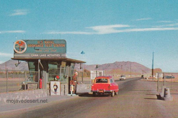
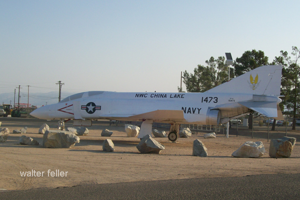
In 1943 the Naval Ordinance Testing Station (NOTS) was established at the Inyokern Airport, which was then called Harvey Field. Following the end of World War II, Harvey Field was deactivated and NOTS aviation operations were transferred to the new Armitage Field at China Lake. Thousands of construction workers, military men and their families settled in the area between the mid to late 1940s, causing a housing boom in the area. In 1943, Ridgecrest had grown to 15 homes and 96 residents. By the 1950s, the population of Ridgecrest exceeded 5000. This population boom led to the development of numerous businesses and facilities, including the Ridgecrest Community Hospital. In 1963 the City of Ridgecrest incorporated. Through the following decades, the City was highly impacted by the changes in NOTS, later China Lake Naval Weapons Center (NWC) and now the Naval Air Weapons Station (NAWS) China Lake.
Today, the City still shares an integral symbiotic role with China Lake, providing housing, and community services for the installation.
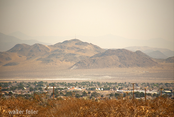
Ridgecrest is located in the southern portion of the Indian Wells Valley and in the northeast corner of Kern County, surrounded by four mountain ranges; the Sierra Nevada on the west, the Cosos on the north, the Argus Range on the east, and the El Paso Mountains on the south. It is approximately an hour and quarter from the Lancaster/Palmdale area and approximately two hours from both Bakersfield and San Bernardino. A favorable characteristic of the City is its proximity to two major highways, the 395 and 14. Air travel in and out of the city is provided through the Inyokern Airport. These attributes make Ridgecrest, a central location for shopping and business for the Eastern Kern County area.
Ridgecrest evolved into a growing and dynamic city during the 1950�s and 1960�s as a support community, vital to the mission of the Navy, by providing housing and services for Federal employees and contractors. Ridgecrest incorporated in 1963 and now provides shopping and services for over 40,000 people throughout the Indian Wells Valley.
China Lake Naval Weapons Center (NWC) and now the China Lake Naval Air Weapons Station (NAWS) is home to the Naval Air Warfare Center Weapons Division, which continues to be the major source of employment for Ridgecrest residents. The economic stability of Ridgecrest as service community for the NAWS has been essential to its successful emergence as a community in its own right. .
As the only incorporated community in the Indian Wells Valley, Ridgecrest boasts a thriving economy and a robust population of just over 27,000 people. Ridgecrest acts as the shopping and business center for northeastern
City of Ridgecrest General Plan
Ridgecrest Weather
Sunny Skies
The Indian Wells Valley has an average of 260 cloudfree days a year, making it an excellent location for aircraft operations and enjoying the sunshine.
Kern County.
Romantic Heritage of the Upper Mojave (1961)
Randsburg
A living ghost town
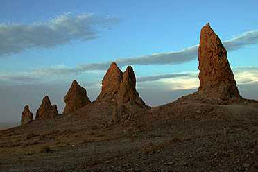
Trona Pinnacles
This eerie, fantastic landscape is one of the most unique geological features in ...
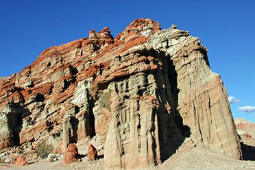
Red Rock Canyon
Red Rock Canyon State Park features scenic desert cliffs, buttes and ...
Burro Schmidt Tunnel
William "Burro" Schmidt spent 38 years digging through Copper Mountain in the ...
