The Needles Road
The first leg of the Needles road, from San Bernardino to the Cajon Summit, was built by the county and opened to traffic in September 1916. The State Highway Department took it over for maintenance two years later, and they then presided over the construction of the second section, Cajon Summit to Victorville, completed in 1922.
The third leg of the road then came under scrutiny,
Victorville to Hicks, 10 miles north of
Helendale. This was the segment that included what was later referred to as the Sagebrush Route.
The work by the state up to this point had been done under the supervision of the Los Angeles office of the State Highway Department, but in October 1923 a new office, District 8, was opened in
San Bernardino, and the District Engineer was E. Q. Sullivan.
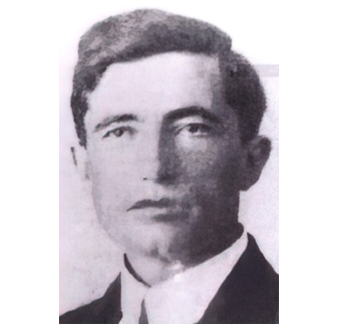
Years later, upon retirement, Sullivan wrote some reminiscences about the road to Needles. He states that he was given instructions to concentrate his resources on connections to Arizona and Nevada.
"The principal road entering California," he said, "was the Needles road.... This was the heaviest traveled road into California. It is my recollection that over 300 vehicles a day passed over this road, headed for the promised land of Hollywood and Los Angeles. Almost no traffic proceeded in the opposite direction."
In 1924 he personally reviewed the road alignment with a trip to Needles. The County Surveyor told him it was a three-day trip: one day to Barstow, the next to Ludlow, and the third to Needles. He was determined to do it in two--after all, Barney Oldfield made it from Los Angeles to Phoenix in just six hours and 40 minutes!
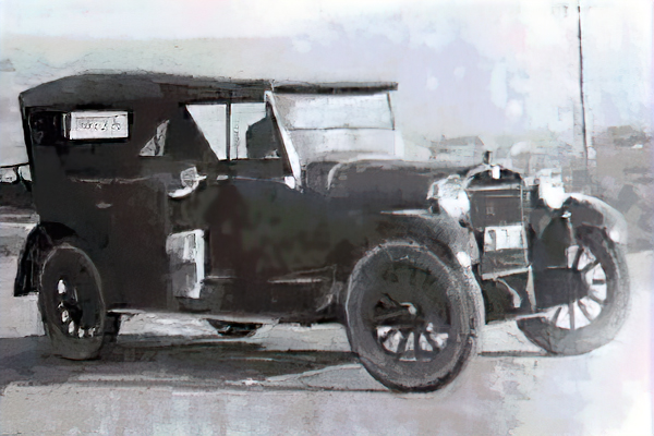
The state had seen fit to provide Sullivan with a brand new Reo, a sporty little number with a cloth top that had celluloid peep holes through the sides and back. He said it was the pride of his heart.
The first segment of Sullivan's trip, San Bernardino to Barstow, went off without any difficulty. He stated that the road surface from San Bernardino to Victorville was the best.
The segment to
Cajon Summit
was a 16-foot-wide oiled macadam road, but it wound through Cajon Pass with 50-foot radius curves, much too tight for modern vehicles, and it had a very high crown with no shoulders. The speed limit at that time was 30 miles per hour, and Sullivan wryly observed, "it was possible to stay on the road at that speed."
The state also had built a 16-foot-wide, high-crowned, oiled macadam road with no shoulders from the Summit to Victorville on a good alignment. From Victorville to Barstow, he stated, the road was "two ruts in the sand and gravel."
He continued his trip the next morning by arising at 3 a.m. and starting off before dawn, determined to avoid the Ludlow layover and make it all the way to Needles in one day. This segment was trouble.
There were long stretches of sandy road, and the car had thin, hard-rubber tires (these were the days before "balloon" tires} which sank into the sand, and at times the transmission and differential would drag along the ground. It was second gear, and even a lot of low gear work, for much of the way.
The road was so narrow, only about a lane and a half, that opposing cars found it difficult to pass each other. When you met anyone, if you were a gentleman, you were supposed to turn out, leaving two of your wheels in one of the ruts by the side of the road and the opposing traffic would reciprocate. It was a problem for cars going in the same direction to pass for the same reason, so cars would bunch up behind the slowest vehicle.
Sullivan recalled that in one caravan he met a string of 10 or 15 cars, and all the cars turned out. Just as he got opposite one car, it jumped back onto the road and on its running board was tied all manner of things, including a tall, round old-fashioned coal oil heating stove. This stove scraped all along the nice new Reo, rolling around and around between the two cars, and spilled coal oil over everything.

Sullivan's Reo
Photo from E. Q. Sullivan's Scrapbook, S. B. Public Library
Sullivan made it into Needles at 11 o'clock that night, quite the worse for wear, as was the car. The Reo of that time had long thin brake rods, and these had all crystallized and broken. The wiring had all come loose and wires were dragging from underneath. The car's lights were all out and it was pitch black.
Sullivan concluded that the County Surveyor had been right....San Bernardino to Needles was a three-day trip. Segments of this road definitely needed new construction.
Road construction from Victorville to Hicks began in 1925, although desert folks were disappointed when they found out in July of that year that due to funding problems the road would only be graded instead of paved.
The construction did provide for future paving with a good subgrade and with rock ballast from quarries in Oro Grande; in other words, a macadam road. The alignment was also designed and constructed with a relatively high-speed traffic artery in mind. The County Supervisor was charged with obtaining the necessary right-of-way, which was for the ultimate design width of 80 feet.
By June of 1926 the third leg of the highway was complete. As it turned out, the road did receive an "oiling" (a cut-rate method of paving) a couple of months after its completion, and 12 years after it was promised in the 1914 bond election.
The use of oil on roads as a pavement surface (not just a dust palliative) went back at least 25 years on the desert, but it had not always met with success. Sullivan rectified the problem. He had found a few sections of road where the oiling had held up superbly, and he studied the mixture to find out why.
There were several factors--soil type for example; it didn't do well in sandy or swampy areas--but the key seemed to be to insure that the right amount and grade of oil was used and that care be given to insure the oil application entirely covered each particle of sand and gravel. With his improvements, oiling became a viable cost-saving method of paving on the desert.
One other factor may have helped get the road paved sooner. San Bernardino had a friend in high places....literally. The governor of the state, Friend Richardson, was a San Bernardino boy. He grew up and went to school there.
Whether or not it was he who found the necessary funds, money was provided so that the road was completed. Our stretch of highway was now ready for the new roadside businesses of the Prohibition and Depression Eras.
< Previous -
Next >
Two Ruts in the Sand
The Needles Road
Chief Bootlegger & Builder
Sagebrush Annie
Roadhouse
Sage Brush Route Tour
.jpg)
Featuring Route 66
.jpg)
It doesn't represent America, it is America!

E.Q. Sullivan - 1914