Ludlow, California
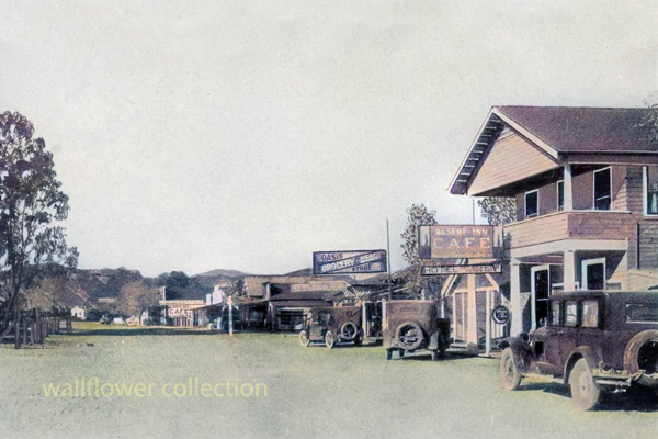
Main St. Ludlow, California 1920 (colorized)
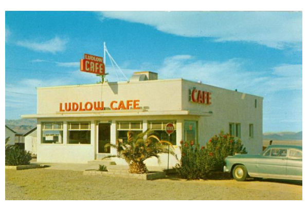
Ludlow Cafe - 1930s
Exploring Ludlow's History
Introduction:
Ludlow, California, a small unincorporated town along Route 66, has a fascinating history stretching back to the late 19th century. Looking into Ludlow's captivating past sheds light on its significant role in California's development and the nation.Early Settlement:
Ludlow's story began in the 1870s when it served as a crucial railway stop along the Atlantic and Pacific Railroad. The town was named Ludlow in honor of William Ludlow, a prominent railroad engineer. Ludlow's establishment facilitated transportation and trade in the region.Mining Boom:
Ludlow experienced a significant boom during the early 1900s, primarily due to the discovery of rich mineral deposits in nearby mines. Gold, silver, and copper mining became the backbone of Ludlow's economy, attracting miners and prospectors from far and wide. The town flourished with the opening of several mines, leading to a surge in population and the establishment of essential amenities such as schools, saloons, and general stores.The Birth of Route 66:
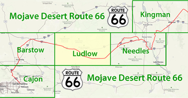
In 1926, Route 66 connected Chicago, Illinois, to Santa Monica, California. Ludlow, strategically located along this iconic highway, became a popular pit stop for travelers, providing essential services and accommodations. The construction of Route 66 brought increased prosperity to Ludlow, as it became a hub for tourists and truckers alike.The Rise and Fall:
Ludlow continued to thrive throughout the mid-20th century, with gas stations, cafes, and motels catering to the needs of travelers along Route 66. However, the town's fortunes took a downturn with the opening of Interstate 40 in the 1970s, which bypassed Ludlow, diverting traffic away from the once-thriving town. As a result, Ludlow gradually declined, with many businesses closing their doors.Preservation and Revitalization:
Despite its decline, Ludlow still bears witness to its storied past. Today, it reminds us of Route 66's golden age, with several historic buildings still standing. Efforts are underway to preserve and restore these structures, allowing visitors to glimpse Ludlow's vibrant past. The town has also become popular with photographers and history enthusiasts, who appreciate its authentic charm and nostalgic appeal.Conclusion:
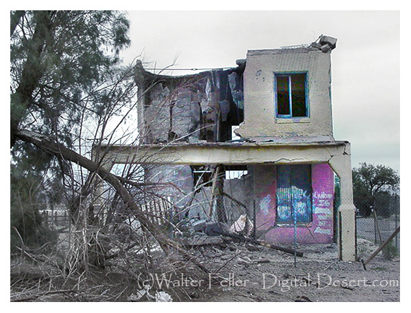
Ludlow, California, has a rich history as a railway stop, mining boomtown, and a prominent pit stop along Route 66. While the town has experienced its fair share of challenges, its historical significance and unique character make it a place worth exploring for anyone interested in California's past. Ludlow stands as an enduring legacy of the Old West and the indomitable spirit of the communities that shaped the American landscape.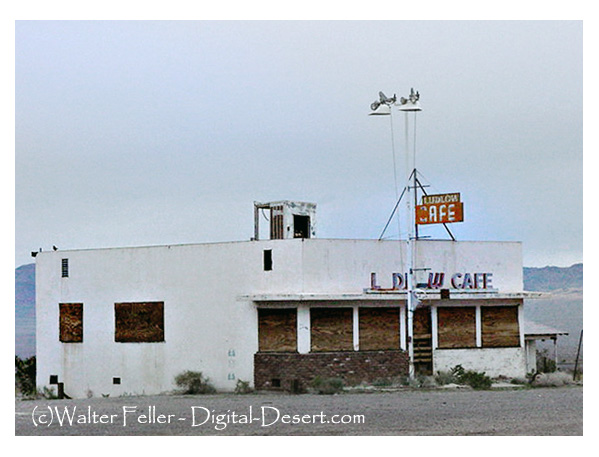 Ludlow Cafe - 2001
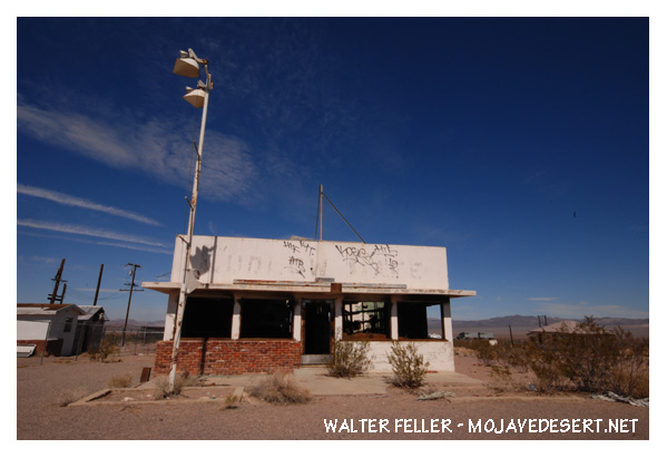
Ludlow Cafe - 2013
The town started as a water stop for the Atlantic and Pacific Railroad in 1883. Ore was found in the nearby hills, leading to a boom. By the 1940s, mining had ceased and the town was left with only the tourist traffic from Route 66. When Interstate 40 was built, there was little business and the residents departed, leaving empty buildings that still stand beside old Route 66.
Ludlow, California, is a small town, with a population of roughly 10 residents, in the Mojave Desert about halfway between Needles and Barstow abutting Interstate 40, continuing it's long tradition of providing services to desert travelers.
A magnitude 5.1 earthquake struck the Mojave Desert at Ludlow December 6th, 2008.
Ref - BLM
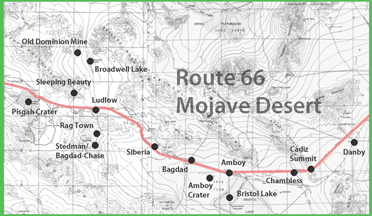
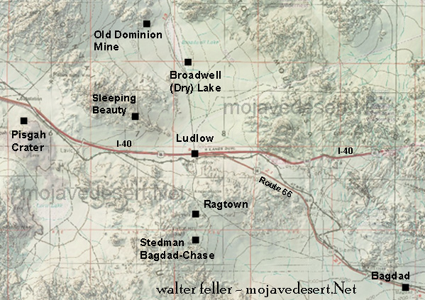
Sleeping Beauty
Broadwell Dry Lake
Tonopah & Tidewater RR
Old Dominion Mine
Stedman/Bagdad-Chase
Ragtown
Area Ecology
Ludlow and Southern Railroad
Ludlow, California, is a small, unincorporated community located in the Mojave Desert. Its history is closely tied to the mining and railroad industries, particularly the Tonopah & Tidewater Railroad (T&T).Ludlow, California
Ludlow was founded in the late 19th century, initially serving as a water stop for the Atlantic and Pacific Railroad, which later became part of the Atchison, Topeka, and Santa Fe Railway. The town experienced significant growth during the mining boom in the early 1900s, providing services to nearby mining operations, including the notable Bagdad-Chase mine.Tonopah & Tidewater Railroad
The Tonopah & Tidewater Railroad was incorporated in 1904 and began operations in 1905. It was financed by Francis Marion Smith, known as the "Borax King," to transport borax from mines in the Death Valley region to the rail connections in Ludlow. The T&T Railroad played a crucial role in developing the mining industry in the Mojave Desert and connecting remote mining towns to major rail networks.Key Facts about the T&T Railroad:
Route:
The T&T Railroad extended from Ludlow, California, north through the Mojave Desert to Beatty, Nevada. It covered a distance of approximately 200 miles.Construction:
The railroad was constructed rapidly, with the line reaching Beatty by 1907.Operations:
The T&T Railroad transported borax, gold, silver, and other minerals, as well as providing passenger services.Decline:
The decline of mining activities in the region, competition from other transportation methods, and the Great Depression led to a reduction in the railroad's profitability. The T&T Railroad ceased operations in 1940.Historical Significance
Ludlow and the T&T Railroad are significant for their roles in the development of the Mojave Desert and the mining industry in the early 20th century. Ludlow served as a critical junction for goods and passengers traveling to and from the mining districts. The T&T Railroad facilitated the economic growth of the region by enabling efficient transportation of minerals and resources.Legacy
Today, remnants of the T&T Railroad can still be found along its original route, and Ludlow serves as a reminder of the bustling activity that once characterized this part of the Mojave Desert. The history of Ludlow and the T&T Railroad is a testament to the challenges and triumphs of mining and railroad enterprises in the harsh desert environment.Ludlow & Southern Railroad

Pendergast Hotel
First Trans-Mojave Railroad
Related pages: Clipper Mountain Wilderness
ACCESS: This wilderness is approximately 28 miles east of Ludlow, ... Access the southern boundary from Route 66, east from the Ludlow to Danby Road. ...
Amboy Crater
The tiny town of Amboy, the home of Roy's Cafe, a few miles to the east, has few, if any ammenities. The closest town to the west is Ludlow. ...
Trilobite Wilderness
Access this wilderness by traveling 28 miles east of Ludlow on Interstate 40, and take the Kelbaker Road exit. Travel south I mile, where the road ...
Bristol Mountains Wilderness
Take the Ludlow exit from I-40 and follow the dirt road north for about 2 miles to ...
Interstate 40
Roads and Trails in the California Mojave Desert
San Bernardino County
Ludlow Cemetery
Baghdad-Chase Mine
About 1898 John Suter, a roadmaster for the ...About 1898 John Suter, a roadmaster for the Santa Fe, headed into the hills south of Ludlow looking for water. Instead of water, he discovered gold, ...
Timeline of History of the Mojave Desert
1905-06 Tonopah & Tidewater railroad built from Ludlow to Tonopah via, Death Valley; abandoned during WW II 1906 Salt Lake CityLos Angeles railroad built ...
Serrano - Territorial Boundaries
... thence Northeasterly in an irregular line to a point approximately 3 miles Northeast of the town of Ludlow; thence Southeasterly in an irregular line to ...
Bagdad Area
... roughly bordered on the north by Interstate 40, the east by the Parker Branch of the Santa Fe Railroad and stretching as far west as Ludlow. ...