Two Ruts in the Sand
There has always been a road along the Mojave River, as long as people have lived in the desert, but the coming of the automobile highway is another matter.There was a burst of enthusiasm for road building by various "road associations" in San Bernardino County and elsewhere in 1913 and 1914. The road between San Bernardino and Needles was designated as part of the National Old Trails Highway, and signs were installed along the route. To call it a road may be a bit of a stretch, as the photograph below demonstrates.
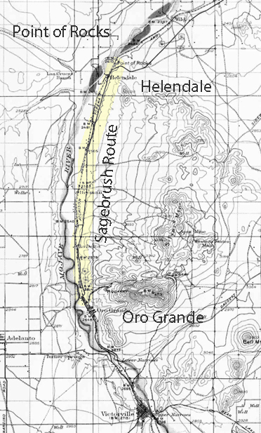
1913 - North of Helen
This photograph, taken from a 1913 tour book, shows the condition of our highway just before the signs were placed. As a later author described it, "Beyond the cultivated circle of the Helendale district, the tawny desert spreads away." In 1913 the desert was virtually roadless, at least as far as improved motor roads were concerned.
To relieve this problem here and in other areas, a bond was proposed for road paving throughout the county. Commissioners were appointed together with their investigative committees to study the routes.
The commission personally inspected the desert road, averaging 14 miles per hour to Needles, which they felt was fairly good time. Cost estimates were calculated, and the newspapers and politicians touted the plan until finally the bond was put before the voters in early 1914.
The bond initially failed, but was successfully reintroduced. It is not certain why the voters had a change of heart, but there was a famous intervening event which brought some good publicity for cars and good roads.
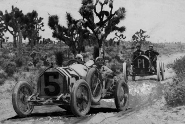
Cactus Derby - 1914
This event was the desert race in which Barney Oldfield was the star attraction. Oldfield was a great race driver, some say he was the greatest ever, and one thing is sure, he attracted attention on the desert.
A race promoter predicted that "Victorville will be the best place on the route to see the best driving and speed, and we are making ample provisions to entertain the big crowds which will come on Sunday and Monday to see the racers go by." He thought the fastest leg of the race would be "...between Los Angeles and Needles, owing to the boulevard between Los Angeles and San Bernardino and the fine road over the divide to Barstow."
When Barney flew through in his No. 5 Stutz, people could speak of nothing else. Enthusiasts talked about it for years, even decades....about the day they saw the famous Barney Oldfield in the great desert race of 1914.
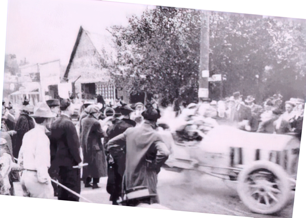
Oldfield racing through Barstow
Courtesy of Peter Wild
This race may have created a desire for cars and for roads to drive them on, thus the passage of the second bond. At that time there were few autos, and none on the desert.
The first car in this region was purchased in 1915, which is noted in this 1919 story about area growth: "The automobile figures are interesting. It was estimated by two of the garage men that there are over one hundred autos in Victorville and vicinity. Three years ago there were exactly four, and it is only one year farther back to the time when Geo. Z. Smith owned the one and only automobile in this district."
These figures corroborate the observations of author David G. Thompson in a government report on water supply in the desert. He gathered his data beginning in 1917 and ending in 1920, and he said that during this time the use of burros and horses and wagons nearly ceased. The age of the machine had arrived. He estimated that, in certain seasons toward the end of the period, as many as 100 cars per day used the road.
He also pointed out that danger did not cease with the advent of motorized vehicles. It became a lot easier to get a long way from watering places, and mechanical failure could spell trouble. He mentioned a time when he personally had to walk 25 miles to obtain help because of a broken axle. Also, there were more people around who were unfamiliar with the area.
On the other hand, the route was rarely out of sight of the railroad. The iron horse was so thirsty that water tanks had to be provided every ten miles or so, and this, in fact, is the main reason for the location of California Route 66.
< Previous - Next >
Two Ruts in the Sand
The Needles Road
Chief Bootlegger & Builder
Sagebrush Annie
Roadhouse
Sage Brush Route Tour
Featuring Route 66
.jpg)
It doesn't represent America, it is America!