Mojave River
The first name given to the river itself by nonIndians was the Garces name, R. de los Martires, or Martyres, which had been the name given by Father Kino to the Colorado River. Bancroft misprinted it as R. de los Martinez. Jedediah Smith called it the Inconstant River. John C. Fremont named it the Mohahave River on his map of the 1844 expedition ; he noted an older name Rio de las Animas.
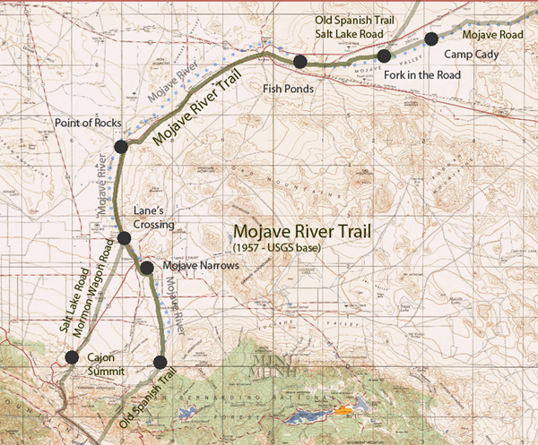
The trails that followed this river had different designations depending on their destinations. At different periods of time, different destinations were important to different people, and some names were used for the roads which had perhaps somewhat local significance. The two main forks from early days of travel were the north fork, leading to Santa Fe and later changing to the Salt Lake City destination; and the south fork, leading to the Mohave Indian villages near the Needles, near which Fort Mohave was later established somewhat north of the Indian settlements. The south fork was improved by expenditure of U. S. dollars for wells known as the Government holes. Through a gradual metamorphosis, the name Government Road or Old Government Road derived from the wells to extend over the entire length of the trail to Fort Mohave (Casebier 1974) . The Spanish/Mexican explorers knew this portion of the road to be the ancient trading route of the Moquis (Hopis) and the Hayatas (Mohaves). By the 1830' the two roads would be locally recognized as the roads to Death Valley and Providence (Lehman) , two names of no importance or significance in the early days of travel along the trails.
During the days of Mexican travel over the trail, the trai1 was simply the route to Alta California. By reference, the trail in the 1840 ' s was designated the Spanish Trail (Fremont), in the 1350 ' s the Great Spanish Trail (Roubidoux) , and the Old Spanish Trail in the 20th Century (Hafen). Generally this designation has been applied to the north fork, but until 1844, both forks were apparently used by the New Mexican commercial caravans and other travellers to California from New Mexico, and thus the route should be given that name for both forks, which would come together again on the Virgin River in eastern Nevada (Warren) Major stops along the Mojave trail were not named until the American period, post 1848. Below is a list of the major stopping places gleaned from published sources and maps most of which were products of the post 1848 traffic. Those Spanish place names that can be identified have been included.
Martin's and the Toll Gate closer to the summit are outside the Desert Conservation Area.
41. Burton's (Casebier 1974):
On desert side of summit, 16.08 miles from summit. May be Cedars stop of Rousseau diary (1964). Not clear where Burton's was. May have been at Victorville, established as Godfrey's Ranch, then owned by Huntington, Hartman and finally, Turner (Mecham, Oct. 1966; Coues, 1900; Wood, 1969). "Little Meadows" another name for Victorville.
42. Upper Crossing:
Approximately at the town of Oro Grande. Station located on the south side of the river between 1865-72 (Keeling, 1976, p. 20).
43. Lane's:
Seven miles below Upper Crossing on Mojave River (Keeling, 1976, p. 20). Possible to leave river here and strike directly for
44. Point of Rocks:
Nickerson's or Nicholson's Ranch. About 3/4 mile below today's Helendale.
45. The Cottonwoods:
About two miles upriver from present Hodge.
46. The Grape Vines:
Jacobi's or Jacoby's, Jacob's Ranch. Later known as Waterman, then Barstow (Coues 1960, Rousseau 1964).
47. Government Station:
Bancroft 1868 map; Farley's Map, 1861.
48. The Fish Ponds:
Marine Depot at Nebo.
49. Forks of the Road:
B. Allcorn's "large inventory" site of 1864 (Keeling, p. 19). After 1874, site of Hawley's Mill, Hawley's Crossing, Hawley's Lake.
Mormon Grocery or Old Grocery. In 1864 was John Havens claim, then known as "Old Grocery" (Keeling p. 19) . May have been Allcorn's place at Forks of the Road, or at the Fish Ponds. Choteau's "Parage de los Navalion" /Hafen, (sic), should be Navajos/, 35 miles from Bitter Springs, could be either Forks of the Road or Fish Ponds. Choteau's mileages were not very accurate, according to Pratt (Hafen, p. 342, n. 5). However, if Choteau's route actually referred to a route via Soda Springs (cf . Warren), this camping spot would be Forks of the Road. El Paso del Sol of Choteau, 18 miles from the Navajo camp ground, could then be either Point of Rocks (Hafen 's route) or Grape Vines (Warren).
Choteau's Los Almos /Alamo_s/ altos, at 25 miles from previous camp, and Amahabo Creek, 45 miles still farther, are probably along the Mohave River itself and do not correlate with the route as it was shortened in the 1860's.
At Forks of the Road, the trail branched into the south and north forks.
South Fork: Spanish Trail; Road to Fort Mojave; Government Road:
50. Camp Cady:
Daniel Cline ranch nearby in 1864.
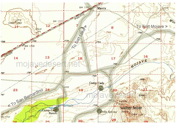
In 1868 the post was moved a half mile to the west.
51. Cave Canyon:
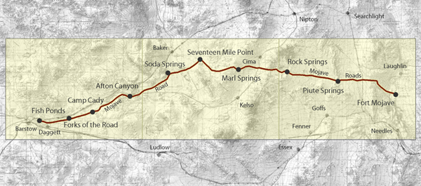
Afton Canyon, Blake's Camp (Casebier, 1972).
52. Soda Springs:
Hancock's Redoubt; Zzyzx of 20th century.
53. Marl Springs
54. Cedar Springs
55. Government Holes
56. Rock Spring
57. Pah-Ute Creek
58. Fort Mohave
Lane's Crossing
Cultural Resources of the California Desert,
1776 -1880 -- Historic Trails and Wagon Roads
Elizabeth von Till Warren & Ralph J. Roske
1981 cultural Russell L. Kaldenberg, Series Editor