Native American History in the Mojave Preserve
Native Americans and Anglo Contact
About 11,000 years ago, the region's ecological zones were one thousand feet lower in elevation than today due to the cooler
and wetter weather patterns of the waning Ice Age.
Streams flowed and lakes existed
where
dry playas
are today. The relative
abundance of plant communities supported
wildlife
and
indigenous peoples
who depended upon the natural resources. While clear
archaeological evidence of human presence in this early time are sparse, over 1,300 later prehistoric and historic period
archaeological resources have been recorded for the large Preserve area, including 65 rock image sites. Museums and professional
researchers have made significant collections of artifacts since 1925.
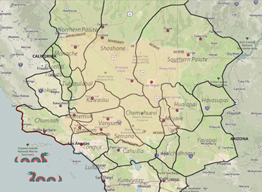
In general, these tribal peoples occupied the lands as small, mobile social units of related families who traveled in regular
patterns and established summer or winter camps in customary places where water and food resources were available. Archaeologists
named
a series of five manifestations of Native American occupation,
which were believed to describe changes in climate, chipped
stone technology, and subsistence practices of these early peoples. These periods covered time intervals from about 5000 BC to
AD 700-900. At that point, the Mojave desert area, unlike other portions of California's desert region, was influenced by native
peoples now called 'Ancestral Pueblo' who established farming villages along the
Muddy,
Virgin,
and
upper Colorado
rivers. Their
culture reached into today's Preserve lands at turquoise sources and via trade trails as far as the Pacific coasts. Later, however,
Ancestral Pueblo peoples abandoned their territory and were replaced by
Shoshonean
and
Paiute
peoples after about AD 1000. In
addition, native peoples of the
lower Colorado River
basin speaking Yuman languages expanded their river zone territory and utilized
some desert lands as well.
Modern Native American "tribes" were products of interactions with the
American military
and legal system as much as modern
reflections of pre-contact Native American land use patterns, and the land allocated to these groups frequently did not reflect
the actual extent of their pre-Anglo homelands. No tribes directly control any lands in the Preserve, but historical, archaeological,
and ethnographic information indicates that ancestors of the modern
Chemehuevi
and
Mohave
Tribes traveled, camped, hunted, and
resided at various places now in the Preserve. Oral traditions and historical information compiled into maps for the 1950-1960s Federal
Indian Lands Claims cases showed Chemehuevi land knowledge and uses. Some Mohave Tribal members have family histories of being on
lands now within the eastern areas of the Preserve. Certainly, the very detailed and lengthy "song cycles" of the Chemehuevi identify
many places within the Preserve with names and events of supernaturals who performed various activities there. The "song cycles" were
a type of oral map of the territory which had great value to travelers moving through the area or following seasonal foraging patterns.
However, both tribal groups sustained hostilities between themselves, which was noted by Spanish
Friar Francisco Garcés
in 1776.
Euro-American contact with peoples now called Chemehuevi or Mohave increased in the nineteenth century. [1]
The Desert Chemehuevi were Native Americans who actually lived most of the year in the area of the Preserve. Limited food and water
resources sustained a low Desert Chemehuevi population density. When food was abundant, it would be dried and cached for later use. The
area of the Preserve probably never supported more than about 150 people at any one time. [2]
While the Chemehuevi were the primary inhabitants of the area now encompassed by the Preserve, the desert and the park itself are named
for a different group of Native Americans - the Mohave. [3] The Mohave were agriculturalists who planted in the flooded plain of
the Colorado River. This agricultural lifestyle generated food surpluses, which enabled them to support a sizable population in the
river basin area, numbering in the thousands. The Mohave frequently traded with other Native American groups to the west and east, and
had a particular fondness for seashells traded by Indians on the California coast. The Mohave had a network of trails across the desert
from waterhole to
waterhole. The
Mohave bragged to early European visitors that a powerful Mohave runner could make the trip to the Pacific
coast, more than 150 miles long, in three days. The Mohave guided some of the first non-Indian travelers over this network of
trails, including friar Garcés in 1776 and American trapper
Jedediah Smith
in 1826. Their network of trails, now known as the Mojave
Road, became one of the main routes used by the government and other travelers to cross the desert before the advent of the
railroad.
The Mohave were friendly to Garcés and Smith at first, but when Smith returned to recross the river in 1827, the Mohaves attacked as his
party was crossing. Historians later determined that other trappers, arriving between Smith's two visits, killed several Mohaves and
antagonized the rest, prompting the tribe to exact revenge on the next Euro-Americans they saw. Half of Smith's party was killed, and
the explorer led the survivors back across the desert trails to relative safety in California. This incident created the reputation of
the Mohaves as a fierce band that should be avoided. [4] Further encounters with trappers in the late 1820s and early 1830s led to more
bloodshed by Indian and Anglo alike. Historians hypothesize that the
Old Spanish Trail,
which runs to the north of the Preserve, was
created in the 1830s specifically to bypass the Mohave. [5]
In 1848, the United States signed the Treaty of Guadalupe Hidalgo to end the Mexican War and received almost all of the territory that
is now the American Southwest, including all of California and all of the area of the Mojave National Preserve. Interest in building
a transcontinental railroad was high, but the choice of route was difficult due to sectional controversies. In 1853-54, the United States
sent several survey teams into the field to report on the feasibility of the various routes. One of these was the so-called
35th Parallel Route,
which cut through the eastern Mojave. Two survey parties took the field: one, under Lt. Robert S. Williamson, explored from the western
side and proceeded as far as
Soda Lake;
the other, under
Lt. A.W. Whipple,
proceeded from Arkansas to Los Angeles, crossing the Preserve
along the route of the
Mojave Road. [6]
Later attempts proved more successful at opening the cross-desert route now known as the Mojave Road. Between 1855 and 1857, the General
Land Office surveyed township lines throughout the area. This effort was largely wasted when the location monuments could not be
rediscovered by others, but the small number of people on the surveying teams became very familiar with the desert and later served as
guides for other expeditions. In 1857,
Edward F. Beale
surveyed a wagon road across the Arizona desert, and crossed the Mojave along
the route of the future Mojave Road. Combined with his eastbound crossing in 1858, Beale's success proved the viability of the wagon road.
1 Lorraine M. Sherer and Frances Stillman, Bitterness Road: The Mojave, 1604-1860 (Needles, CA: Mohave Tribe / Ballena Press, 1994). I am indebted to Roger Kelly, Senior Archeologist, NPS Oakland, for much of the information and wording in the preceding paragraphs. Comments by Roger Kelly on first draft, June 25, 2002. For information about Chemehuevi songs, consult Carobeth Laird, The Chemehuevi (Banning, CA: Malki Museum Press, 1976), 9-19.
2 Chester King and Dennis G. Casebier, with Matthew C. Hall and Carol Rector, Background to Historic and Prehistoric Resources of the East Mojave Desert Region (Riverside, CA: Bureau of Land Management, California Desert District, 1981), 20.
3 Generally, the tribe and places named after the tribe in Arizona are spelled "Mohave," the fort in Arizona, the desert, and other places in California are spelled "Mojave." See Dennis Casebier, The Mojave Road, Tales of the Mojave Road #5 (Norco, CA: Tales of the Mojave Road Publishing Co, 1975), 182n1.
4 This incident was likely precipitated by violence toward the Mojave by an earlier trapping party, under the command of Ewing Young. Later trappers, such as Peter Skene Ogden, also massacred Mohaves without warning, contributing to the tension. Casebier, Mojave Road, 24-28.
5 Casebier, Mojave Road, 30-31.
6 Casebier, Mojave Road, 57-66.
Source - NPS:
From Neglected Space To Protected Place:
An Administrative History of Mojave National Preserve
by Eric Charles Nystrom
March 2003
https://www.nps.gov/parkhistory/online_books/moja/adhi2.htm
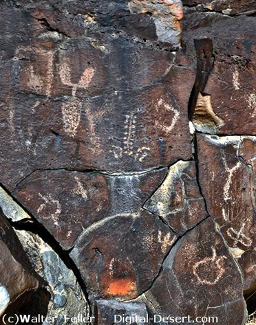
Petroglyphs