The Ancestral Mojave River
The watershed of the Mojave River = approx. 3670 sq miles (9500 sq km)
Contents
-
San Bernardino Mountains
Upper Watershed
-
East Fork
West Fork
Confluence
-
A flowing together of two or more streams, or a point at which streams combine
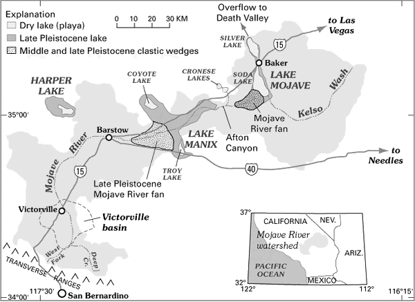
Victorville Basin
Upper Narrows
Helendale
Harper Lake
Lake Manix
Afton Canyon
Mojave River Fan
Cronese Basin
Lake Mojave
Salt Spring & the end of the Mojave
Overflow to Death Valley
Map Reference:
Enzel, Wells, & Lancaster - Paleoenvironments and Paleohydrology of the Mojave and Southern Great Basin Deserts
USGS Mojave River Maps
Mojave River Drainage Ecology
Dry Lakes
This model was developed from a presentation titled 'The Ancestral Mojave River' By Professor Norman Meek to show what the Mojave River and its network of lakes may have looked like before the arrival of man--As a simple aid to visualize the river and its lake system from a crude geological standpoint, and not a depiction of the paleoenvironment including the flora and fauna of those times.Programs to modify these images and produce effects such as lakes with water and removal of any manmade objects from the image were used as necessary. Unaltered photos have been used when possible.
Chronology of the Ancestral Mojave River
-
11-10 Ma. (million years ago)
The region sloped toward the Pacific Ocean
8-7.6 Ma.
Birth of ancestral Transverse Ranges (San Gabriel fault)
3.5 Ma.
San Gabriel Mountains rise blocking the slope to the ocean and forming marshlands. Ancestral Deep Creek coming out of the San Bernardino Range begins to appear.
2.5-2 Ma.
Continued rise of the San Bernardino Range along the San Andreas fault reverse the regional drainage direction.
1.5-1 Ma.
The development of faults further to the north and east.
.5 Ma.
Appearance of perennial lakes Harper and Manix
70-80 ka. (thousand years ago)
Ancestral Mojave River develops as an incised channel with a course.
Also see: