The Ancestral Mojave River
Lake MojaveLake Mojave existed in the region of Soda and Silver Lake basins.< Previous <> Next > |
clickable map 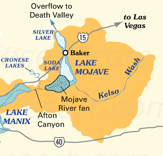
|
Abstracts
Late Pleistocene-Early Holocene Geomorphic History of Lake Mojave, CaliforniaH. THOMAS ORE and CLAUDE N WARRENGeology Department, Idaho State University, Pocatello, Idaho 83201 Department of Anthropology, University of Nevada, Las Vegas, Nevada 89109 An elongate basin at the termination of the Mojave River contained pluvial Lake Mojave, now represented by Silver and Soda Lake playas near Baker, California. During overflow, water level was controlled by an outlet channel at the north end of Silver Lake. Geomorphic features, including wave-cut cliffs and beaches, and stratigraphic information from lacustrine deposits around the playa margin, indicate alternating periods of high and low water. Twenty-four radiocarbon dates on shell material and calcareous tufa from six locations allow correlation with other researchers conclusions from nearby areas to provide the following chronology. A major lacustral interval ended about 14,500 yrs ago, with water overflowing the outlet at the 941- to 943-ft level. The second lacustral, from about 13,750 to 12,000 yrs ago, caused extensive development of shoreline features at the same level. During the third high water period, from 11,000 to just before 9,000 yrs ago, cutting of the outlet to the 936-ft level occurred. A final lake from 8,500 to 7,500 yrs ago did not overflow the outlet. Flood Frequency of the Mojave River and the Formation of Late Holocene Playa LakesYehouda EnzelDepartment of Geosciences, The University of Arizona, Tucson, Arizona 85721, USA Perennial lakes lasting several decades occupied Silver Lake playa, the terminus of the Mojave River, as recently as 390 � 90 and 3620 � 70 BP. Flood routings from the Mojave River headwaters to its terminal playa, and water balance calculations for the resulting lakes, indicate that floods comparable in magnitude to the largest floods in the modern record must occur almost annually to generate and maintain perennial lakes. In contrast, the modern floods of this magnitude have recurrence intervals greater than 18 years. Such an increase in flood frequency is required even if lake evaporation is reduced by as much as 50%. Modern extreme floods of the Mojave River are related to meridional atmospheric circulation and a southeastward shift in the winter low pressure center over the North Pacific Ocean, causing vigorous storms over the headwaters in the San Bernardino Mountains of southern California. This winter pattern probably occurred more frequently to induce the large number of storms and floods needed to form the middle and late Holocene lakes in Silver Lake playa. Also see: Lake Mojave PeriodDeath Valley prehistoric culture - Lake Mojave Period, 10000-5000 BC.Playas - Mojave Preserve - California Mojave DesertThis expanded lake system is known as ancient Lake Mojave. The surface of Silver Lake playa is more than 10 feet lower than the low end of Soda Lake playa ...Soda LakeAt least twice, a long-lived lake (Lake Mojave I and II) existed in the region of Soda and Silver Lake playas, from about 18000 to 16000 years ago and from ...The Mojave River and Associated Lakes - Mojave Desert Geology... and Cronese basins), and Lake Mojave (including dry Soda Lake and dry Silver Lake basins)(see the map on the Changing Climates & Ancient Lakes page). ...Changing Climates and Ancient Lakes Mojave DesertAt the peak of the last Ice Age, the Lake Manix overflowed into Lake Mojave (which included both Soda Lake and Silver Lake basins). The Mojave River also ...Mojave Desert Ecological SubsectionsHumans have been utilizing the area for some 10000 years; the early Lake Mojave Paleoindian hunting assemblage is well documented at sites along the shores ...Sand Dunes & DustIn addition, the extent of ancient Lake Mojave during highstands in lake levels in the Quaternary may have isolated Kelso Dunes from their sediment source ...History of Death ValleyClaims have been made for archeological assemblages dating to times earlier than the Lake Mojave period, but all are debatable and have little . ...Soda LakeArea Satellite Image |