--
|
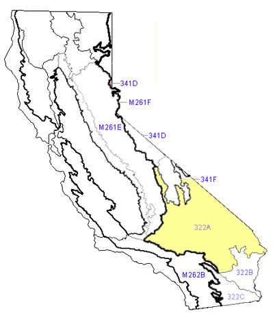
Ecological Sections: Mojave Desert
Section 322A
Mojave Desert
Mojave Desert - Section 322A Overview
This region of the Mojave Desert spans from the southern Sierra Nevada and northern Transverse Ranges into Nevada and Arizona. Much of the region falls under two chief land areas known as MLRA 30 and MLRA 29.
Geographical Characteristics
The area is a mixture of mountains, plateaus, sand dunes, dry lakebeds (playas) and basins. The region is part of the Basin and Range province, which gives the desert its unique geography.
Rocks and Soil
The substrate at this site includes:
Rocks dating back millions of years (Cenozoic and Precambrian ages)
Sediments washed down from mountains
Saline areas occurring in some basins.
Soils are mostly dry types called Aridisols and Entisols, which are common in deserts. In cooler mountain areas, soils hold more moisture.
Plants
The arid environment hosts various flora, such as:
Creosote bush and Joshua trees.
Halophytic flora, e.g. saltbush and iodine bush
Junipers and pinyon pines at higher elevations Along streams and wet areas, youll find willows and cottonwoods. Some invasive plants, like tamarisk and annual grasses, have taken over in some spots.
Animals
This desert is full of life, even if it looks empty at first glance:
Mammalian species include bighorn sheep, coyotes, foxes, kangaroo rats, and jackrabbits.
Aves: Accipitridae, Strigiformes, Falconidae, Geococcygia, Odontophoridae
Reptiles: desert tortoises, rattlesnakes, and chuckwallas (big lizards)
Climate
The Mojave is hot and dry:
It receives only 3-8 inches of rain per year, mostly in short, heavy storms.
The average temperature ranges from 45°F to 77°F.
The growing season (when plants can grow) is 175-325 days long.
Water
Much of the water flows through canyons in mountainous rocky areas, finally disappearing into dry basins. Some areas drain eastward to the Colorado River, which has numerous reservoirs impounding water.
Natural phenomena
Fires: These are less common in arid regions but occur more frequently in damper locations with much vegetation.
Floods: Rapidly occurring flash floods frequently emerge following significant rainfall events. How People Use the Land
Cultural Ecology
Humans have greatly changed the Mojave over the years
Mining and ranching in the late 1800s and early 1900s brought new plants and animals that upset the balance of nature.
Contemporary endeavors such as military experimentation,off-road leisure activities, and urban expansion have made a significant impact.
History This region has been inhabited by individuals for more than 10,000 years.
Paleoindians camped by ancient Lake Mojave. Later groups moved their settlements to gather seasonal resources, like plants and small animals.
Farming, influenced by cultures from the Colorado River, reached the area around A.D. 1000.
Borax and other mineral mining formed a lot of the landscape in the 1800s and early 1900s.
The economy today deals mainly with government jobs, mining, ranching, and tourism.
|
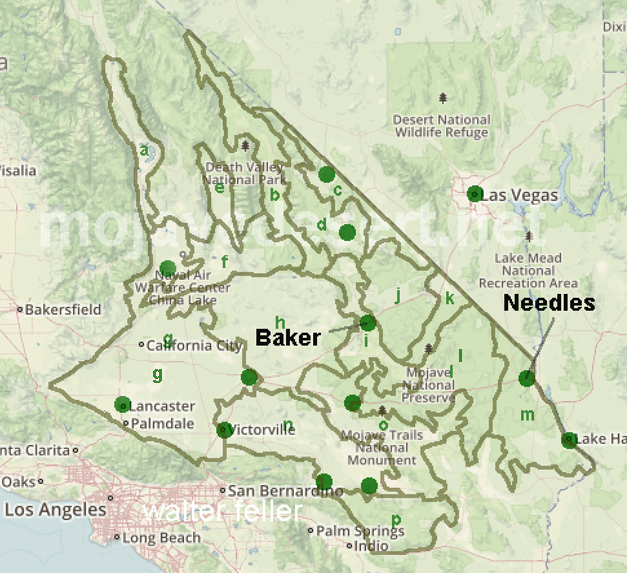
322A Subsections - The Mojave Desert section is divided into
16 subsections, 322Aa - 322Ap
a - Owens Valley
b - Death Valley
c - Amargosa Desert - Pahrump Valley
d - Funeral Mountains - Greenwater Valley
e - Panamint Valley
f - Searles Valley - Owlshead Mountains
g - High Desert Plains and Hills
h - Mojave Valley - Granite Mountains
i - Silurian Valley - Devil's Playground
j - Kingston Range - Valley Wells
k - Ivanpah Valley
l - Providence Mountains - Lanfair Valley
m - Piute Valley - Sacramento Mountains
n - Lucerne - Johnson Valleys and Hills
o - Bullion Mountains - Bristol Lake
p - Pinto Basin and Mountains
|