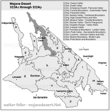
Subsection 322Ab
Death Valley
Death Valley's alluvial plain stretches from Sand Spring down to the divide between Death Valley and Silurian Valley. It's an extreme environment, with scorching heat, minimal rainfall, and vast open spaces shaped by wind and water over thousands of years. Geology and LandscapeThis part of Death Valley is mostly built from materials that have washed down from surrounding mountains over time. The land is made up of alluvial fans (cone-shaped deposits of sediment), old lakebed deposits, and windblown sand. In some places, you'll find dunes, especially on the eastern sides of the playas. There are also small patches of older, Pliocene-age sedimentary rock.
The landscape is mostly flat to gently sloping, but as you move toward the higher fans, the terrain becomes steeper. If you look closely, you can still see beach ridges and old shorelines from when the valley was filled with ancient lakes. The lowest point, Badwater Basin, sits at 282 feet below sea level, while some surrounding areas rise to about 4,000 feet. Erosion from flash floods and the constant movement of wind-blown sand are the primary forces shaping this land.
Soils
The soils here are well-drained and mostly dry, made up of different types of sandy, rocky, or clay-rich ground. The central part of Death Valley has extremely hot soil temperatures, which makes it tough for plants to grow. Many of the dry lake beds are so salty that nothing but the most salt-loving plants can survive.
Plant Life
Despite the harsh conditions, plants have adapted to life here. On the alluvial fans, you'll find creosote bush and desert holly dominating the landscape, with allscale (a type of saltbush) becoming more common toward the southern end of the valley. In washes, brittlebush and white bursage thrive, taking advantage of occasional rainfall.
In lower areas where ancient lakes left behind salty soils, iodine bush and saltgrass manage to survive. Around salt marsh edges, mesquite and arrowweed take root, often marking spots where groundwater is slightly more available. But out on the dry lakebeds themselves, where the salt levels are sky-high, you won't find much more than crusted earth.
Climate and Water
Death Valley is one of the driest places on Earth, with only about 3 to 5 inches of rain per year. The average temperature ranges from a mild 60F in winter to a blistering 77F or higher in summer, and some areas stay frost-free for most of the year.
Water is a rare sight. When it does rain, the runoff from alluvial fans is fast and furious, while basin areas collect water more slowly. There's no outlet for surface water here--everything that flows in either evaporates or soaks into the ground. The Amargosa River, the main waterway leading into Death Valley, is usually dry but has a few springs that provide some much-needed moisture.
In short, this is one of the toughest environments on Earth, shaped by relentless heat, wind, and time. Yet, despite its extremes, Death Valley's alluvial plain tells a fascinating story of ancient lakes, shifting sands, and life finding a way in the harshest of conditions.
< previous - Mojave Desert - next >


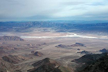
Looking east across Death Valley from Aguereberry Point in the Panamint Mountain Range