--
Subsection 322Ae
Panamint Valley
This subsection is the alluvial plain of Panamint Valley, between the Argus and Panamint Ranges. It has a hot and arid climate. MLRA 30g.
Lithology and Stratigraphy. This subsection contains mostly Quaternary alluvial fan, basin-fill, and lacustrine deposits. There is dune sand around the edges of the lake beds, or playas, and on alluvial fans at the northern end of the valley.
Geomorphology. This subsection is on predominantly nearly level lake plain and basin floor and gently to moderately sloping alluvial fans. The valley is oriented toward the north-northwest. Elevation range is about 1000 to 5000 feet. Fluvial erosion and deposition, and eolian deflation and deposition are the main geomorphic processes.
Soils. The soils are mostly Typic subgroups of Torriorthents, Torripsamments, Calciorthids, and Haplargids on alluvial fans; Typic Torrifluvents and Typic Torriorthents in basin-fill; and Typic Salorthids on lacustrine deposits. Much of the lake plain is playa that lacks vascular plant cover. There are Typic Torripsamments on dune sand, but much of it is barren, lacking plant cover. The soils are well drained, except for poorly drained playas. The soil temperature regimes are thermic. Soil moisture regimes are aridic.
Vegetation. The predominant natural plant communities are Creosote bush series low on fans and Shadscale series high on fans. Mixed saltbush series is common on basin floor and Iodine bush series and Saltgrass series are present on wet basin-fill and lacustrine deposits. Greasewood series occurs in riparian areas and around saltmarsh. Much of the dry lake plain is devoid of vascular plants.
- Characteristic series by lifeform include:
Grasslands: Alkali sacaton series, Desert sand - verbena series, Indian ricegrass series, Pickleweed series, Saltgrass series.
Shrublands: Brittlebrush series, Creosote bush series, Creosote bush - white bursage series, Desert-holly series, Fourwing saltbrush series, Greasewood series, Iodine bush series, Mixed saltbush series, Scadscale series, White bursage series.
Forests and woodlands: Mesquite series.
Surface Water. Runoff is rapid from alluvial fans and slow from basin-fill. Drainage is internal, there is no outlet for surface water. A large area south of Panamint Valley drains into the valley. Streams are dry most of each year. There is temporary ponding on playas, or dry lake beds.
< previous - Mojave Desert - next >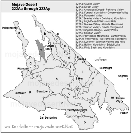
clickable map - select a section to view
Points of Interest
Attractions and points of interset in the Panamint Valley. Including ghost towns, gold mines, highways, ...Death Valley National Park
Panamint Springs areaGeology:
- Father Crowley point
- Darwin Canyon
