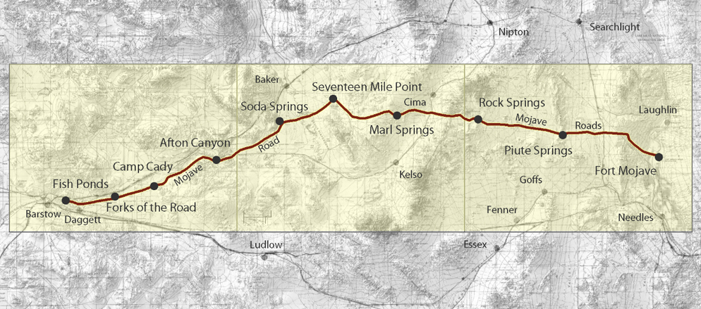
Mojave Road
The Mojave Road is a historic 140-mile trail crossing the Mojave Desert, deeply tied to centuries of travel, trade, and exploration.
Origins
Long before it became known as a road, the Mojave and Anasazi used the route as a footpath for trade. Turquoise and other goods moved westward to coastal tribes like the Chumash. The Mojave, living along the Colorado River near todays Needles, acted as key traders, guiding and enduring the harsh desert to maintain these exchanges.
Spanish and Fur Trapper Era
By the late 18th century, Spanish explorers and missionaries used the trail, with figures such as Father Garces passing through. In the 1820s, American fur trappers followed, including Jedediah Smith, who hired Mojave guides to navigate the desert. Tensions eventually arose between tribes and outsiders, leading to fewer travelers and a decline in fur trade along the route.
Military Road
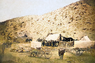
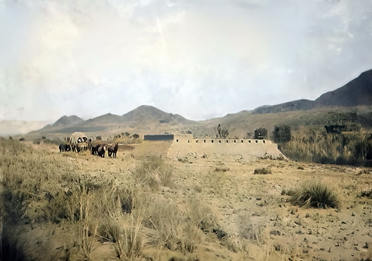
After the Civil War, the Mojave Road became strategically important as a link to Prescott, then capital of Arizona Territory. Native resistance and attacks on travelers prompted the U.S. Army to build forts along the road, including Fort Mojave, Marl Springs outpost, and Camp Cady. These strongholds offered protection for mail carriers, settlers, and wagon trains pushing west.
Decline
As technology advanced, the roads importance faded. Steamships hauled goods up the Colorado River, bypassing the desert route. When the Atchison, Topeka & Santa Fe Railroad reached the region in 1883, the Mojave Road was left behind as little more than a dusty track.
Legacy
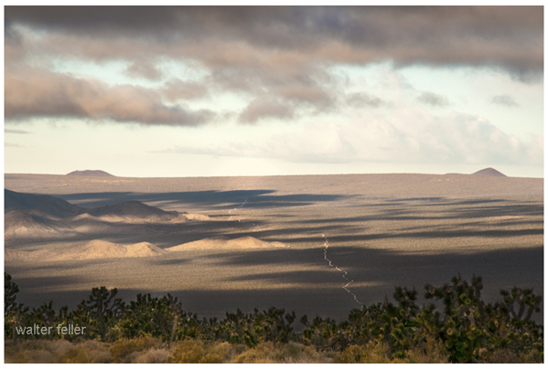
Today, the Mojave Road is an open-air history book. From Soda Lake to Afton Canyon, travelers encounter landscapes and landmarks once vital to survival: Marl Springs, Seventeen Mile Point, Soda Springs, and Camp Cady. Though abandoned as a main route, the road embodies the determination of Native traders, Spanish priests, American pioneers, and soldiers who endured the Mojave.
Modern Use
Now part of the Mojave National Preserve, the Mojave Road is popular with off-roaders, hikers, and history buffs. It offers not only a rugged desert adventure but also a living connection to the stories and struggles that shaped the American West.
Pre-contact Mojave, Anasazi, and other Native groups use the route for trade, carrying turquoise and goods between inland and coastal tribes.
1776 Father Francisco Garces travels the route, recording his journey and interactions with the Mojave people.
1826 Jedediah Smith crosses the Mojave Desert using Mojave guides, becoming the first known Anglo to do so.
1830s1840s Sporadic conflicts between Mojave and travelers. Decline of fur trade reduces non-Native use of the route.
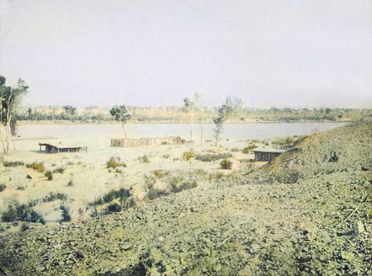
1859 Fort Mojave established on the east bank of the Colorado River to protect travelers entering the desert. It becomes a key supply point and garrison.
1860 Camp Rock Spring briefly established to guard water sources along the route but abandoned due to isolation and difficulty in resupply.
1863 The Mojave Road is officially designated a military wagon road. The Army begins patrols to secure mail and travel routes.
1866 Marl Springs outpost established to guard a critical desert waterhole. This small garrison protects one of the few reliable sources of water on the central Mojave stretch.
1866 Camp Cady established on the Mojave River, east of present-day Barstow. The post provides protection for travelers, wagon trains, and mail carriers along the western section of the road.
1867 Soldiers stationed at Marl Springs fend off Native attacks, underscoring the importance of the location as a desert stronghold.
1868 Fort Mojave becomes the main supply and command center for military operations across the Mojave Road.
1860s1870s The Mojave Road operates under military escort. Supply lines run between Fort Mojave, Marl Springs, Soda Springs, and Camp Cady. These posts anchor Army control of the desert.
1883 Completion of the Atchison, Topeka & Santa Fe Railroad across the Mojave bypasses the old road. Military posts are gradually abandoned, and the Mojave Road falls into disuse.
20th century The road remains a faint track, used by ranchers and rediscovered by historians and desert adventurers.
Today Preserved in Mojave National Preserve, the Mojave Road is a historic trail traveled by off-roaders and history enthusiasts. Key military landmarks still remembered include Fort Mojave, Camp Rock Spring, Marl Springs, Soda Springs, and Camp Cady.
History of Eastern Mojave & the Mojave Road
Historic Mojave Road - 1863
Across America - Prescott to Los Angeles
Indian Trail
Jedediah Smith
Fr. Garces
Fort Mohave
Marl Springs
Camp Cady
Afton Canyon
Camp Cady
History of Camp Cady
Covert Operations
Fork in the Roads