The Brown Ranch
Predecessor of the Rancho VerdeBy Richard D. Thompson
--"RUMOR HAS RUN STRONG THROUGH THE DECADES ABOUT THE FIRST OCCUPANT OF THE FAMED RANCH...."
The origin of the Brown Ranch (later known as the Cole, Verde, Grier, and the Kemper Campbell Ranch) is of considerable interest and importance to the Victor Valley area.
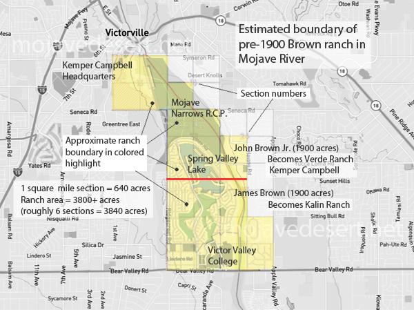
Approximate boundaries of Brown Ranch
At one time the ranch exceeded 3,000 acres, extending from what is now the intersection of Apple Valley Road and Bear Valley Road at its southeast corner, all the way north and west to the vicinity of the Upper Narrows of the Mojave River, where a remnant of the ranch still exists. The property included the area now occupied by Victor Valley College, Spring Valley Lake, Mojave Narrows Regional Park, the commercial properties on Bear Valley Road, and other subdivisions and miscellaneous adjacent parcels.
It has been rumored that John Brown Sr. established the ranch in 1867, that he did so by homesteading the property, and that it was he who named it the Rancho Verde (or Verde Ranch). Some even hold that Brown built his toll road to the ranch from Cajon Pass.
If these ideas were not started by Josephine Rumble in her history of the Old Government Road, she certainly fixed them in the firmament. Historians and commentators on the desert have used her work as a major reference for decades; however, although a good source for its time, it has become outdated and contains some errors.
My wife Kathy and I disputed these notions in our book Pioneer of the Mojave: The Life and Times of Aaron G. Lane. We listed numerous legal documents to support our position, including a deed, property transfer, cattle registry, possessory claim and mortgage. Of course, we only briefly touched on the subject, since our book was about Aaron Lane, and not the Brown Ranch.
Author Erma Peirson directly addressed the issue in her book The Mojave River and its Valley. She is wary of the hearsay, but cannot quite put her finger on the solution:
Rumor has run strong through the decades about the first occupant of the famed ranch which has been called the Brown Ranch and the Verde before it received the current name. Homestead records have not come up with any answer, and it has clung to the Brown usage rather consistently.
John Brown, Sr., who was very busy helping the West to grow, receives some of the honor for the name, although there is no proof that he lived on the Narrows ranch lands....There has been a strong feeling that John Brown, Jr., may well have been the one who lived there and for whom the ranch was named.
She then quotes a little known report by W. F. McClure and others, entitled, Report on the Utilization of Mojave River for Irrigation in Victor Valley, California, which states the "first occupation" was by James Brown:
Rancho Verde includes 3,800 acres in the Mojave River bottom just above the Upper Narrows. The first occupation was about 1867 by James Brown, a cattleman who pre-empted land and by 1874 had 1,500 acres fenced and a ditch from the river. Cole and Harris, who acquired the property about 1894, added more land by purchase, constructed another ditch, drilled wells, and started a dairy.
Except that the dates are a bit off, the McClure statement is substantially correct.
I will now show through public records and newspaper accounts that James and Joseph Brown settled the ranch in 1870 and lost the heavily mortgaged property in 1898. That although both John Browns, father and son, had financial interests in the ranch at one time or another, there is no evidence yet uncovered that either ever operated, maintained or lived on the property. Further, no one (Brown or otherwise) homesteaded any of the Brown Ranch. It was all purchased or claimed, and the name Rancho Verde was never applied to it until owner John A. Cole incorporated the Rancho Verde Company in 1901.
WHO OWNED AND OPERATED THE BROWN RANCH?
The initial piece of property was bought by John Brown Jr. and Joseph Thorn at $1.25 per acre (the current price for public land), for a total of $600 for three-quarters of Section 26, T. 5 N., R. 4 W. They bought it in 1869 but did not receive the patent until 1871, at which time Thorn, who was probably just a financial partner, ceded his interest to Brown in a land swap.John Jr. likely bought the property for his brothers, since he was an adult and they were minors. John was born in 1847, so he would have been 21 years of age in 1869, 22 after his birthday (October 23). His brother Joseph was a year younger, James three years, and Newton eleven years.
The view that John just assisted his brothers is buttressed by the fact that Joseph filed a claim to 160 acres of adjacent land the following year on his own, as soon as he legally could. John sold the Section 26 property plus 480 acres of Section 36, making 960 acres in all, to Joseph and James in 1875.
The supposed founding date of 1867 for the ranch has a definite drawback: namely that there is testimony that nobody was living there then. George Miller said as much when he described chasing Indians that year with a group of trappers and scouts that was humorously dubbed the "Army of the Pacific."
In Annual Publications, Historical Society of Southern California, he told of tracking the Indians out to the desert and said, "We then moved down to the Mojave River to get closer to our work, in some heavy timber--the place is now known as the Verde Rancho; it was not owned by anybody at that time." He meant not "occupied" as can be seen by a close reading of the rest of the text.
Since they camped at the ranch site, in fact headquartered there, he would certainly have mentioned any improvements. And there was no one to feed him or his fellow Indian fighters. After a battle near present Lucerne Valley, the group had to return all the way to James Fears' Upper Toll House in Cajon Pass for food. "We hadn't had a square meal for thirty-two days," he complained.
The date the ranch was established can be determined with reasonable accuracy (within a year) thanks to the omniscient County Assessor. One might think that given the vast expanse of the County, the Assessor might miss a ranch now and then, but he seemed to know everything.
Prior to 1870 there were no entries for the Brown Ranch or any ranch that might conceivably have been located in Section 26 in the Assessment Records, but in 1870 there is an entry that states "Brown and Thorn, 480 acres of land" followed by the legal description. This entry was hatched out in pencil and was incomplete. There was no valuation, and only the land was listed, so it may just be a recognition that the land was purchased, and then scratched out because the transaction had not been consummated with the government as yet.
There is a clear entry for the following year showing the ranch as a working concern. One of the four assessment books for that year has a heading on the cover that reads, "assessment roll for fiscal year ending April 1871." That most likely signifies that an entry could have been made any time in the previous year, meaning that the Browns could have moved to the ranch sometime between May of 1870 and April of 1871. The Brown assessment appears on page 8 of an unnamed book. The heading reads, "Brown Joseph & Bro" and is reprinted here.
Joseph Brown turned 21 in 1870, and on September 5th of that year he began adding land to the original purchase. He filed a claim in Section 23 just north of the 480 acres his brother had purchased the year before. In that claim he said, "Notice is hereby given that I, Joseph Brown, have taken up, settled up on, occupy and claim for agricultural and grazing purposes" 160 acres of land, for which he gave the legal description. He also swore that he was a citizen of the United States over 21 years old.
Three months later John Sr. transferred the JB cattle brand to both Joseph and James, indicating that the two brothers were then in the cattle business. So we have Joseph's own statement that he had "settled upon" the land by September 1870, and this corresponds with the data provided in the Assessor's records.
This makes sense, considering the other developmental activity in the immediate vicinity that year. Earlier, Lafayette Mecham had cut a road directly through the desert from Fish Pond (Daggett) to Big Meadow (Victorville), and this route -- known today as Stoddard Wells Road -- became popular because it was shorter and firmer than the Mojave River Road, which had some sandy stretches. The Stoddard Wells route was extended to the south to make a connection with the Cajon Pass toll road. The combined roads became the major thoroughfare, and Lane's Crossing on the Mojave River Road became the secondary route, as this map shows
1870's Wheeler survey map
PORTION OF LT. GEORGE M. WHEELER'S ATLAS NO. 73, SURVEYED ON THREE SEPARATE OCCASIONS DURING THE YEARS 1871-1878.
Quick to realize the economic importance of the new crossing, John J. Atkinson built a cabin in about 1870, downstream of the Upper Narrows. Partners A. F. (Frank) McKenney and Jesse W. Taylor followed with a supply station further downstream, approximately in the vicinity of where the present-day Southdown Cement Company's Mojave Northern Railroad crosses the river. Their possessory claim filing was the same month and year as Joseph Brown's, in September 1870.
It is understandable that the Browns came to their ranch after an access road was provided and adjacent lands were being settled. McKenney and Taylor's station (well known later in the 1870s as Huntington's) would be a welcome convenience as well as an economic factor in increasing land values.
An 1872 news account discusses James Brown's hunting exploits in the ranch area, an indication that he was either living or spending time there:
MOUNTAIN SHEEP -- We were presented on Friday, a fine ham of mountain sheep by Mr. James Brown, for which we say, "thank you," Jim. He succeeded in capturing this timid "varmint" at the great narrows on the Mojave River. A few days since he came very near throwing a lasso on one, in his endeavor to get from in front of a buck.
WAS THE RANCH HOMESTEADED?
Neither John Brown Sr. nor any of his four sons, John Brown Jr., Joseph, James or Newton, homesteaded any property in San Bernardino County.In checking rootsweb.com and Bureau of Land Management records for all of the property supposedly owned by the Browns, it was discovered that much of the ranch was patented to the Southern Pacific Railroad in the 20th Century, including all of Section 15 and three-quarters of Section 23. This means that a good deal of the ranch was made up of possessory claims, grazing rights or something other than a full and complete title.
Also, there were other parcels which purportedly belonged to the ranch but were patented to various individuals, all in the 20th Century. In fact, the only property patented to the Browns, other than the original purchase by John Jr. and Joseph Thorn (480 acres), was 160 acres which the youngest brother Newton purchased in the 1880s.
How the Section 36 property was obtained is unknown, but it would have been administered by the state, and could not have been homesteaded. Sections 16 and 36 in each township were granted to California by the Congressional Act of March 3, 1853, the proceeds from which were to be used for public education.
This gives some significance to the statement in the McClure report that James "had 1,500 acres fenced." It was fenced but apparently not owned. The railroad patents were issued long after the Browns had lost the ranch, but the legal entanglements must have been a mess for their successors, which is another whole story in itself.
WHEN DID IT BECOME THE RANCHO VERDE?
The end of the Brown ownership of the ranch is covered in some rather sad newspaper accounts. The Browns had used the property as a piggy bank for many years, mortgaging it for various ventures. It is not the purpose of this history to go into all the details, but James and Joseph and Newton's interests kept going up and down.In the 1890s there was a severe financial recession, and many businesses throughout the nation began to fail. James tried to sell the property to a developer, as detailed in a May 8, 1896, story subtitled, "The Brown Ranch at Victor Provisionally Transferred," which appeared in the San Bernardino Times-Index:
The deeds have been placed on file by which James Brown grants to the Columbian Colonization company between 3000 and 4000 acres of land, situated in the basin about the Victor narrows, and which, according to the plans of the colonization company, is to be the site of a reservoir....This was probably a desperate attempt to either raise money or salvage something from his estate. Joseph's fortunes were inextricably tied up in the First National Bank of San Bernardino, and in 1894 the bank was forced to close its doors. Two years later, a receiver began to foreclose on the bank's mortgages in order to recoup depositors' funds. These proceedings eventually reached the Brown Ranch partners and both brothers were financially ruined.
On March 4, 1898, the Weekly Times-Index announced, "Jim Brown Ranch Sold." The article was subtitled "Result of a Foreclosure of Mortgage Forced by a Bank Failure," and opened with these words:
The failure of the First National Bank in 1894 has resulted in forcing many to the wall. Jim Brown, brother of the President of the defunct institution, is one of the recent indirect victims. He was one of the most prosperous men in the county.
The story goes on to detail how the property was auctioned off on the court house steps.
 Times-Index foreclosure article
ARTICLE REFERS TO JIM BROWN'S RANCH,
NOT JOHN SR'S, AND THE NAME IS THE
BROWN RANCH, NOT THE RANCHO VERDE
Times-Index foreclosure article
ARTICLE REFERS TO JIM BROWN'S RANCH,
NOT JOHN SR'S, AND THE NAME IS THE
BROWN RANCH, NOT THE RANCHO VERDE
During this period the ranch is always referred to as the Brown Ranch, never as the Rancho Verde. The property, after being acquired by the mortgage holders, was then bought by John A. Cole, H. E. Harris and Milo M. Potter. On October 19, 1901, these three plus some others filed Articles of Incorporation for the Rancho Verde Company (which are located in the San Bernardino County Archives).
The main purposes of the corporation were:
To purchase, improve, hold and sell real estate, water rights and priveleges (sic), building reservoirs and ditches, laying pipes and distributing water; to buy, sell, and own horses and cattle, to operate ranches, breed horses and cattle, buy and sell grain, hay, and all kinds of farm products and do any and all things necessary to properly conduct and operate a general farming and stock ranch business.
Prior to the incorporation of the Rancho Verde, no references to it by that name have been found.
Cole's selection of the name Rancho Verde seems to be fitting. Verde, of course, means green, and even in the hottest days of summer there is always plenty of greenery down along the river to contrast with the surrounding desert. The name and atmosphere of the place was perfect for a guest ranch, which it became for many decades.
The ranch changed hands a couple of times before Kemper and Litta Belle Campbell, with partner A. W. Sorenson, bought the property in 1924. They continued to use the Rancho Verde name, but when the Campbell's son, also named Kemper, was killed in a plane accident while training during World War II, Litta Belle changed the name to "Kemper Campbell Ranch" in his honor.
It is well known by that name today, but oldtimers, even some family members, still call it the Rancho Verde as well. Actually they call it the "North Verde," because the southern portion went to Sorenson when the original property was split in two. The south property later became the Kalin Ranch.
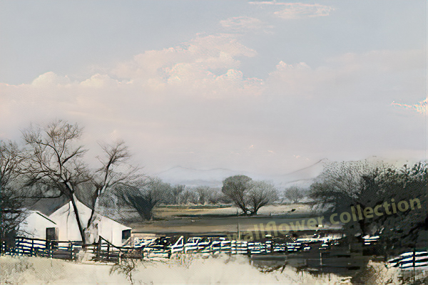
Picture of North Verde Ranch
PHOTO OF NORTH VERDE RANCH, VICTORVILLE, CALIFORNIA, TAKEN FROM 1940'S POSTCARD
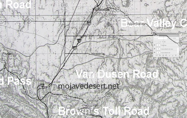
One last bit of explanation is necessary: why the name John Brown appears where it does on Wheeler's Atlas No 73. The map, shown once again below, was prepared by surveys done during 1871-1878, and is the map to study for students of formation of the road network in the Mojave Desert.
At the bottom left, the map shows the road coming up from San Bernardino to the Cajon Pass Summit, continuing north to Lane's. Also shown is the new road going down, southwest from Fish Pond (top right on the map), to Huntington's and on down to Cajon Pass.
1870's Wheeler survey map
SITE LOCATION SHOWN AS "JOHN BROWN" (SOUTHEAST FROM LANE'S) CAN BE SCALED FROM THE MAP, AND IS APPROXIMATELY ONE MILE SOUTH OF TODAY'S BEAR VALLEY ROAD WHERE IT CROSSES THE MOJAVE RIVER, WHICH MEANS THAT IT IS ONE MILE SOUTH OF THE MOST SOUTHERLY BOUNDARY OF THE BROWN RANCH.
The first road to branch off to the east beyond the Cajon Summit is the Van Dusen Road. It can be seen rounding a hill, circling back up into the mountains by Rock Springs, Rattlesnake Springs, and going on into Bear Valley.
The second road to branch off to the east goes to the vicinity of Rabbit Springs and turns south up into the Cushenbury grade, and into the east end of Bear Valley. In the Apple Valley area this road is located approximately along the alignment of present-day Del Oro Road, or a mile south of Bear Valley Road.
On this road the map shows the name "John Brown" written at the crossing of the Mojave River, and the site is about one mile south of the most southerly boundary of the Brown Ranch. In the years 1874-75, Brown and his partner Kate Foulkes had a contract to carry the mail from San Bernardino to Big Bear. The mail was carried in a wagon together with freight and passengers. The crossing of the Mojave would have been a perfect place to change horses, and it is quite likely that this was a stop for just such a purpose when the second Wheeler survey was taken.
John Brown Sr. is an historic character of significant prominence: a Rocky Mountain fur trapper, an Argonaut, and one of San Bernardino's Founding Fathers. He was engaged in a high-profile project nearby, the John Brown toll road, and he seemed to be larger than life. He worked with the Indians in trying to establish a ferry across the Colorado River, he delivered the mail to Big Bear, he was Justice of the Peace, Judge of the Plains, and one of three commissioners who oversaw the creation of San Bernardino County. It is not surprising some believe he had founded one of the most famous ranches on the Mojave Desert, but in this instance, credit must go to his sons.
---