Forks of the Road
Previous - Next
Forks of the Road (often recorded as Fork of the Road) was one of those consequential Mojave River oases where water surfaced and routes naturally converged. In a country ruled by distance and thirst, this was a practical place to water stock, camp, and make decisions before committing to the next stretch of desert.
Old Spanish Trail / Mormon Road (Los AngelesSalt Lake Road)
In the 1830s1840s the Old Spanish Trail linked Santa Fe and Los Angeles through a chain of hard-won watering places. Later, after 1847, Mormon and other emigrant wagon parties developed what became widely known as the Mormon Road (also called the Los AngelesSalt Lake Road), following much of the same corridor where it made sense for wheels and livestock. From this vicinity on the Mojave River, that route could leave the river and angle away across the desert toward the interior, continuing the long overland connection to Utah.Mojave Road (Mohave Trail / Old Government Road)
The Mojave Road grew out of an older Indigenous travel corridor that tied the Colorado River to the Mojave River and, by following the river upstream, on toward Cajon Pass and the settled valleys beyond. By the mid-19th century it had become a recognized overland road for soldiers, mail, miners, and freightused because it stitched together scarce water sources across a very large, very dry country.The Forks of the Road
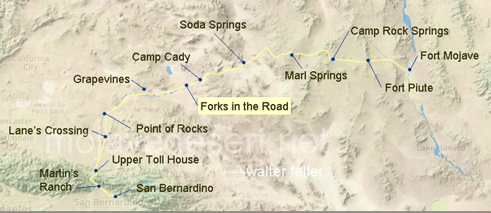
This junction mattered because it offered choices. Parties could stay with the Mojave River upstream toward Cajon Pass and San Bernardino, or they could leave the river and strike out across the open desert on the fork that carried travelers onward toward other basins and distant destinations. Either way, this was the last sensible place to pause, check animals, top off water, and decide how to spend the days miles.Modern-Day Connection
The historic locale sits east of Barstow along the Mojave River. The larger BarstowYermo reach is still a crossroads in the old sense of the word: major routes continue to funnel through this part of the desert, and junctions still shape the way people move across the Mojave.The importance of this spot shows up again and again in travel accounts and route descriptionsbecause in the Mojave, reliable water and clear decisions were never small matters.