Panamint Springs Area
Places to see and things to do in the Panamint Springs area of Death Valley National Park
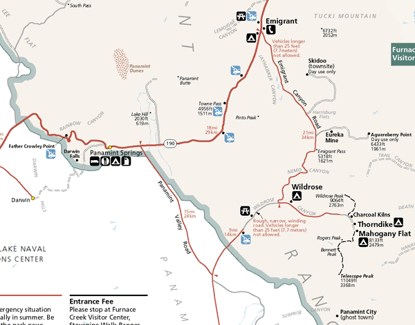
Clickable Panamint Springs Area Map
Click here to zoom out to the Death Valley Map
Source and references: NPS and others
|
Digital-Desert :
Mojave Desert
|
| Intro:: Nature:: Geography & Maps:: Parks & Preserves:: Points of Interest:: Ghosts & Gold:: Communities:: Roads & Trails:: People & History:: |
|
|
Death Valley:
Panamint Springs AreaPlaces to see and things to do in the Panamint Springs area of Death Valley National Park Clickable Panamint Springs Area Map
Click here to zoom out to the Death Valley Map Source and references: NPS and others |
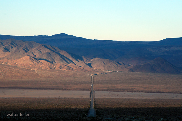
Darwin FallsA miracle in the desert, this spring-fed waterfall flows year-round in a narrow gorge. Its lush streamside thickets of wilows ring with the song of migrating birds in springtime. Located just west of Panamint Springs via a 2.5 mile unpaved road. Although there is no formal trail, the mostly level, one-mile walk to the falls involves some rock scrambling and several stream crossings.Father Crowley VistaA landscape of dark lava flows and volcanic cinders abruptly gives way to the gash of Rainbow Canyon below this viewpoint. Walk the dirt track east of the parking lot for a grand overlook of northern Panamint Valley. Vista located west of Panamint Springs on Hwy 190.Lee Flat Joshua TreesThe finest stands of tree-sized yuccas in the park grow in this mountain-rimmed valley. Take the paved but rough Saline Valley Road to a junction in Lee Flat. The gravel roads in either direction will provide good views of Joshua trees.Wildrose Charcoal KilnsThese ten beehive-shaped structures are among the best preserved in the west. Built in 1876 to provide fuel to process silver/lead ore, they still smell of smoke today. The last 2 miles of gravel road to the kilns are passable to most vehicles. Located in upper Wildrose Canyon in the Panamint Mountains.Aguereberry Point1000 feet higher than Dante’s View, this viewpoint gives a perspective over Death Valley from the west. Along the gravel road is the remains of Pete Aguereberry’s camp and his Eureka Mine. The last climb to the point may require a high-clearance vehicle. Located in the Panamint Mountains off Emigrant Canyon Road.Panamint ValleyPanamint Springs, CAHighway 190 |
| Intro:: Nature:: Geography & Maps:: Parks & Preserves:: Points of Interest:: Ghosts & Gold:: Communities:: Roads & Trails:: People & History:: |
|
Digital-Desert :
Mojave Desert
|
|
Country Life Realty Wrightwood, Ca. |
Mountain Hardware Wrightwood, Ca. |
Canyon Cartography |
G.A. Mercantile |
Grizzly Cafe Family Dining |
|
Abraxas Engineering privacy |
For educational use only; not a travel or safety guide. Copyright (c) Walter Feller, 1995-2026. All rights reserved. |