Highway 18
Beginning in the western Antelope Valley, east through the Victor Valley to Lucerne Valley, then south to Big Bear Lake, then becoming the Rim of the World Highway, west past Running Springs and Lake Arrowhead, then south to San Bernardino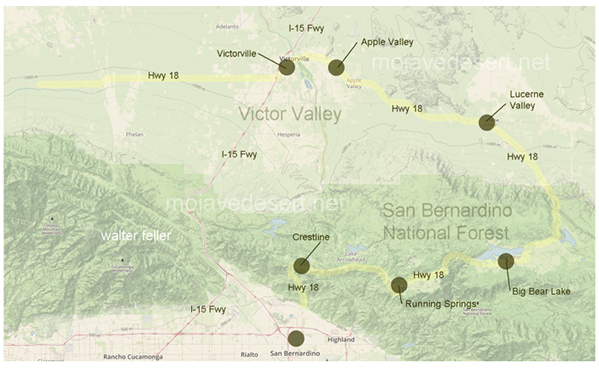
State Route 18 is one of the major highways in Southern California, affording some of the most scenic drives through diversified landscapes: from the western Antelope Valley, it runs eastward through the Victor Valley, passing through communities such as Palmdale and Victorville. This section of highway serves to connect desert towns and enables commerce on the local level.
From Lucerne Valley, the highway then heads south toward Big Bear Lake and upward into the San Bernardino Mountains. It is here that the road becomes noted for its scenic wonders and commonly known as the "Rim of the World Highway." The highway curves around mountain ridges so that wide views of the valleys below and the far-off desert land come into view.
Going west from Running Springs and near Lake Arrowhead, SR 18 is covered by dense forests and provides access to various areas suitable for hiking, camping, and winter sports. The elevation and rolling landscape of this road make it popular among visitors who want to enjoy nature and outdoor fun.
Lastly, it heads south to San Bernardino and intersects with other highways that have other primary roads. This section provides crucial access between mountain towns and city areas in the Inland Empire.
Key Points of SR 18:
Western Antelope Valley to Victor Valley: This route connects the desert towns and serves as a business highway.
Lucerne Valley to Big Bear Lake: Head up into the mountains for some of the most beautiful views and resort areas. Rim of the World Highway: famous for nice views and round mountain roads. Running Springs and Lake Arrowhead: Goes through wooded areas with some opportunities for outdoor recreation. Descent to San Bernardino: Offers a transition from mountainous high-altitude regions to metropolitan cities.
Travel Tips:
Highway Conditions: Because of its varying elevations, weather plays a huge factor in road conditions. Winter months commonly see snow and ice.
Safety: Be alert for sharp curves and steep grades, especially on the Rim of the World Highway.
Recreational Access: There are lots of interesting places in the route for nature lovers, including trailheads, picnic spots, and lookout points. Whether you drive to work, enjoy the natural splendor of Southern California, or seek fun in the mountains, Highway 18 offers a great drive through some of the area's most different and beautiful places.
Victor Valley
Victorville
Apple Valley
Lucerne Valley
San Bernardino National Forest
Big Bear Lake
San Bernardino
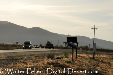
Highway 18 at Deadman's Point
Happy Trails Highway 18
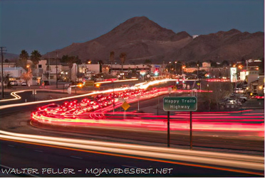
Happy Trails Highway, also known as California State Route 18, runs through Apple Valley, California, and is famously linked to Roy Rogers and Dale Evans, the Western film stars. The highway was renamed "Happy Trails Highway" in honor of their signature song "Happy Trails." Apple Valley became the home of Roy Rogers and his wife, Dale Evans, and they were deeply connected to the community, promoting it as a great place to live.
The highway itself stretches through the scenic desert landscape of the Victor Valley, connecting cities like Victorville and Apple Valley to Big Bear and other mountain communities. It's a well-traveled route for both residents and tourists exploring the Mojave Desert, including popular landmarks like the Apple Valley Inn and Roy Rogers' house. The name adds a nostalgic touch, evoking the Western spirit and heritage of the area.