Automobile Blue Book, 1921
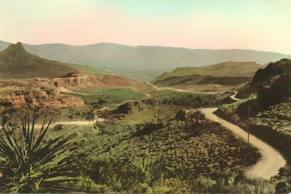
National Old Trails Road from Kingman, Az. to Oatman, Az.
For motorists in the 1910s and early 1920s, the Automobile Blue Book was essential for traveling the unmarked primitive roads of the period. As the title page of the 1921 and other editions put it:
The Blue Books cover the entire United States and Southern Canada in twelve volumes. They tell you where to go and how to get there, giving complete maps of every motor road, running directions at every fork and turn, with mileages, all points of local or historical interest, state motor laws, hotel and garage accommodations, ferry and steamship schedules and rate. A veritable motorist’s encyclopedia.
Instead of the road maps that would soon become the standard for road atlases, the Automobile Blue Book relied on descriptions that a motorist, or more likely a passenger, could read to stay on the intended road. Directions might involve turns at a stated building, a painted barn, a notable tree, a trolley, or a railroad crossing.
By the early 1920s, the publisher employed official pathfinders in Blue Book cars to update the listings. As John T. Bauer noted in an article about the guides:
Today, the method of navigating by detailed mileages and turn-by-turn directions may appear cumbersome and unnecessary to some drivers, especially those who excel at map reading, but those techniques were ideally suited for the conditions of automobile travel during the first two decades of the twentieth century. Roads at the time were constructed with only local uses in mind and often lacked descriptive signage. Prior to the automobile, roads that stretched across the country, or even a state, in an unbroken fashion were unnecessary. Traveling that far was reserved for railroads. Therefore, anyone wishing to travel cross-country by automobile was forced to make hundreds of turns onto hundreds of different roads. Such details could not have been depicted at an appropriate scale on a sheet map because of the generalization that would have been required. Publishers and automobile enthusiasts turned to route guides such as the Official Automobile Blue Book and their turn-by-turn directions as a more effective solution. [Bauer, John T., “The Official Automobile Blue Book, 1901-1929: Precursor to the American Road Map,” Cartographic Perspectives, Winter 2009, pages 4-27]In talking and writing about the National Old Trails Road, Judge Lowe gave the roadway as positive a description as he could. Segments were hard surfaced in many States, funds were available for hard surfacing, or the pavement was good except for a stretch here or there. The 1921 edition of the Automobile Blue Book, Volume T (“Main Trunkline Highways of the United States”) covered the National Old Trails Road/Santa Fe Trail broken into segments, each assigned a route number, found throughout the book. In addition to helpful directional guides, each entry commented on the road itself as observed by those without a vested interest in the success of the named trail.
Route Segments 625-629
Flagstaff, Az. to Los Angeles, Ca.Route 625 – Flagstaff to Kingman, Ariz. – 177.4 miles
Via Williams, Ashfork and Seligman.
Graded gravel and dirt to Seligman, poor road to a point 6 miles east of Peach Springs, good road to Hackberry, followed by graded gravel to Kingman.
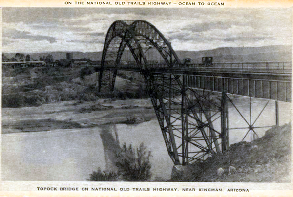
Route 626 – Kingman, Ariz., to Needles, Cal. – 71.0 miles
Via Yucca and Topock.
Good graded, gravelly dirt to Yucca, fair to poor road to Topock, good road to Needles. Good time can be made between Kingman and Yucca and again from Topock to Needles, but the intermediate distance slows travel, owing to many cross washes. The route traverses a desert country, crossing the Colorado river on a steel bridge at Topock. Make local inquiry regarding road via Oatman which may be preferable to text here given.
Route 627 – Needles to Barstow, Cal. – 166.2 miles
Via Goffs, Amboy, Ludlow and Daggett.
The road is either of gravelly sand or of an oil surface. Between Amboy and Ludlow the old road is still preferable to the new road which follows the south side of the RR. Both, however, are in very poor condition. Average road conditions on this route are good and very fast time can be made except between Amboy and Ludlow. This route crosses the Mojave desert and owing to the intense heat during the summer months, tourists frequently make this run at night.
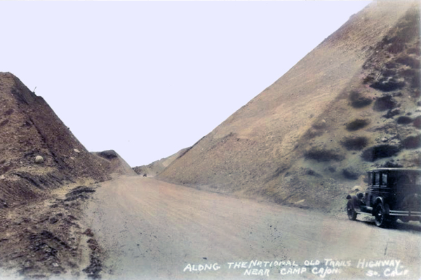
Route 628 – Barstow to San Bernardino, Cal. – 81.7 miles
Via Victorville.
Gravel and sand road to summit of Cajon pass, balance macadam and concrete. After crossing the western edge of the Mojave desert and reaching the summit of Cajon pass, the tourist is suddenly confronted with a magnificent panorama of incomparable grandeur. Descending on easy winding grades over splendid roadway with high mountains towering on all sides, the tourist almost abruptly finds himself within the semi-tropical vegetation of southern California.
Route 629 – San Bernardino to Los Angeles, Cal. – 63.3 miles
Via Foothill Blvd. and Pasadena.
Paved roads all the way.
Historic Trails
Scenic Byway
Cross-Country Route
American Heritage Road
Pioneer Trails
Highways
Transcontinental Travel
Roadside History
Auto Touring
Historic Landmarks
Western Trails
Historic Roadways
Route 40
Transcontinental Highway