--
Alabama Hills
Alabama Hills Recreation Area is a geologic phenomena located in nearly 30,000 acres of public land west of Lone Pine, CA.
History
The Alabama Hills gather their name from a Confederate warship responsible for wreaking havoc to northern shipping during the Civil War. Prospectors sympathetic to the Confederate cause named their mining claims after the Alabama and eventually the name stuck to these unique hills.
The fame of the C.S.S Alabama was both brilliant and short lived. Yankee warships finally cornered the Alabama off the coast of Normandy. There, in a running gun battle with the Northern steamsailer, U.S.S. Kearsarge, she was sunk in the summer of 1864. This event provided northern sympathetic miners to indulge in the art of "one-upmanship," by naming a whole mining district, mountain pass, a peak and a town, "Kearsarge".
Geologic History
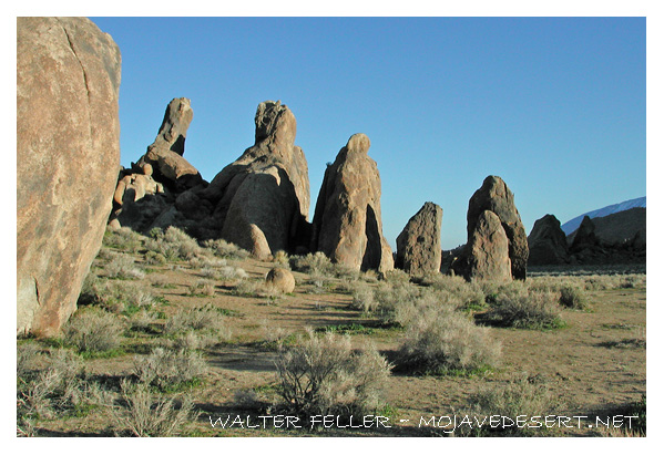
The rounded, weathered contours of the Alabama's, form a sharp contrast between the crisply sculptured ridges of the Sierra. This leads the viewer to believe the Alabama's are almost antique in nature. Actually, both geologic features were shaped by the same cataclysmic uplifting 100 million years ago. Millennia of wind, snow and eons of wind blown sand have blasted across their contours. These were the tools that sculpted the outstanding formations of weathered granite in the Alabama's.
Take a Hike
Photographers come from all over the country to photograph this amazing view, and the Alabama Hills Arch is a bonus. Whether you are here for the Sierra views, identifying native plant life or photography, this area offers a variety of activities. The Alabama Hills Arch Nature Trail Walk was created in partnership with the Eastern Sierra Interpretive Association and the Alabama Hills Stewardship Group. Directions to the trailhead:
-
Take Hwy 395 to Lone Pine.
Turn west (at the stop light) onto Whitney Portal Road, drive 2.5 miles to Movie Road, turn right.
After 1.5 miles you will come to a "Y" in the road.
Go right and pull into the dirt parking area immediately on your left.
You will see the trail sign on the left side of this parking area; this is where you begin your arch walk.
The walk takes approximately 15 min. round trip and the terrain is hilly.
Film History
The outstanding features and environment of the Alabama Hills have attracted movie makers, commercial companies and tourists from all over the world. Since the early 1920's, movie stars such as Tom Mix, Hopalong Cassidy, Gene Autry and the Lone Ranger, have been shooting it out with outlaws. Classics such as Gunga Din, Springfield Rifle, and How the West was Won, were filmed at sites now known as "Movie Flats" and at Movie Flat Road. During 1993 portions were filmed with Mel Gibson for Maverick , released in 1994. A massive set was built in the Alabama's formations and filming continued for three weeks. Portions of scenes for the movie The Shadow were filmed during 1993, starring Alec Baldwin. Some movies filmed more recently have been GI Jane, Star Trek Generations and Disney's Dinosaur. The Alabama's serve as the backdrop to many commercial and still advertisements each year in a huge variety. Clothing ads, models, camping gear, electronics, vehicle and Federal Express ads to name a few. It was a first in 2005 to have the Alabama's used as the background for a video game. The community of Lone Pine hosts an annual three day event called the "Lone Pine Film Festival" every Columbus Day weekend in October. They feature guest speakers from previous films, actors, guided bus tours and over 120 photo plaques mounted at the original movie site locations for the public to enjoy.
Take Care
While enjoying the scenic and recreational values of the Alabama Hills, hikers, rock climbers and sightseers should use the utmost caution at all times. The few remaining mine shafts and tunnels in the general area should be avoided because of the extreme hazards they represent. False bottoms might give away or tunnels collapse because of deteriorated shoring timbers. The Alabama Hills are beautiful, but there are hazards that could injure the unwary or unprepared visitor.
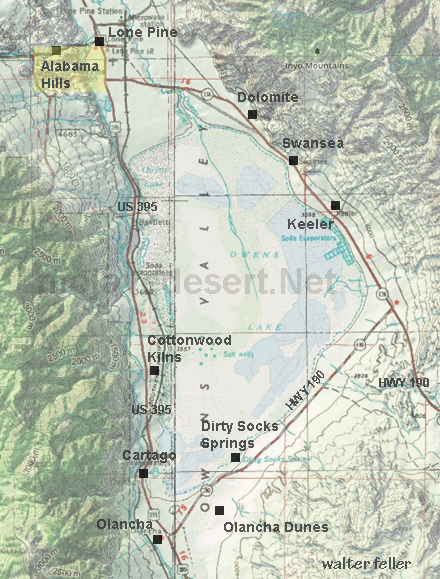
Owens Valley
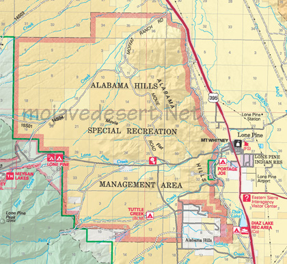
Photo Gallery
Also see:
Alabama Hills
Eastern Sierra & Death Valley SUV Route Guide ...
Mojave Desert Ecoregion:
... the alluvial plain in the southern part of Owens Valley, from ...
Sierra Nevada Ecoregion:
... a hot to very cold and arid to humid climate. ..
Geomorphic Provinces:
Another graben, Owens Valley, lies between the bold eastern fault scarp of the Sierra Nevada and Inyo Mountains. ..
.. a tilted fault block nearly 400 miles long. Its east face is a high, rugged multiple scarp, contrasting with the gentle western slope (about 2 ) that disappears under sediments of the ...