Section M261E - Sierra Nevada
(click here for interactive map)
![]() This section is the temperate to very cold parts of the Sierra Nevada, which
is a north-northwest aligned mountain range that is much steeper on the
east than on the west side. It is in MLRA 22.
This section is the temperate to very cold parts of the Sierra Nevada, which
is a north-northwest aligned mountain range that is much steeper on the
east than on the west side. It is in MLRA 22.
Geomorphology. Block mountain range tilted west; accordant crests. Sierra Nevada Range geomorphic province.
Lithology. Mesozoic granitic and ultramafic rocks, Paleozoic and Mesozoic strongly metamorphosed sedimentary and volcanic rocks, and Cenozoic volcanic rocks.
Soil Taxa. Alfisols, Andisols, Aridisols, Entisols, Inceptisols, Mollisols and Ultisols in combination with mesic, frigid or cryic soil temperature regimes and xeric, udic, aridic or aquic soil moisture regimes.
Vegetation. Predominant potential natural communities include the Mixed conifer series, Ponderosa pine series, Jeffrey pine series, White fir series, Red fir series, Lodgepole pine series, Huckleberry oak series, Western Juniper series, Aspen series, Big sagebrush series, Mixed subalpine forest series, Mountain hemlock series, Whitebark pine series and Giant sequoia series.
The following series are found throughout the section and are not restricted to or extensive in any subsection. Series dominated by exotic plants are not listed under subsections unless they are extensive and stable.
-
Series dominated by exotic plants: Broom series, California
annual grassland series, Cheatgrass series, Introduced perennial grassland
series, Kentucky bluegrass series and Tamarisk series.
Series that can occur in all subsections, but are not extensive: Bulrush series, Bulrush - cattail series, Bur-reed series, Common reed series, Cattail series, Creeping ryegrass series, Ditch-grass series, Duckweed series, Holodiscus series, Mosquito fern series, One-sided bluegrass series, Pondweeds with floating leaves series, Pondweeds with submerged leaves series, Quillwort series, Saltgrass series, Sedge series, Spikerush series, Tufted hairgrass series and Yellow pond-lily series.
Series restricted to riparian settings: Black cottonwood series, Mixed willow series, Montane wetland shrub habitat, Mountain alder series, Narrowleaf willow series, Pacific willow series, and Red willow series (see montane riparian).
Elevation. 1,000 to 14,495 feet. Local relief ranges from 500 to 2000 feet.
Precipitation. 10 to 90 inches during fall, winter and spring. Occurs mostly as snow above 6000 feet. Rain on snow is common. Summers are commonly dry with low humidity.
Temperature. 25° to 60°F.
Growing Season. 10 to 200 days.
Surface Water Characteristics. Many rapid flowing rivers and streams. Rivers flow west from the crest in deeply incised canyons with bedrock controlled channels to the Great Valley section and Pacific Ocean. Rivers flow east from the crest in mostly bedrock controlled channels terminating in basins in the Mojave Desert, Mono or Northwestern Basin and Range sections. There are numerous lakes and wet meadows associated with glaciated areas above 5,000 feet.
Disturbance Regimes.
- Fire: At lower and mid-elevations, historic occurrence has changed
from frequent, low intensity ground fires to infrequent, high intensity
stand replacing fires. At higher elevations, historic occurrence
has changed from infrequent, low and moderate intensity ground fires to
infrequent, low, moderate and high intensity surface or stand replacing
fires.
Seismic Activity: Seismically active areas along eastern boundary with strong shaking and ground rupture.
Climate: Wide fluctuations in precipitation and temperature for periods of years result in significant or catastrophic changes in biological communities. Snow avalanches are common at higher elevations.
Cultural Ecology. Humans have been utilizing the Sierra
Nevada for about 10,000 years, and have been an integral part of its ecology
for 3,000 to 5,000 years, particularly with documented use of fire to facilitate
gathering and to generate species preferred for foodstuffs, basketry materials,
and other needs. Extensive procurement and processing of lithic,
acorn, pine nut, basketry fiber, and other resources resulted in innumerable
areas of lithic quarry, bedrock mortar, pinyon, Jeffrey pine, sugar pine,
oak grove, and other resource alteration. Contemporary attitudes
and beliefs are dichotomized between emphasis on amenity/newcomer and commodity/long-time
resident values. Human environment is characterized by a rural lifestyle
of open space and outdoor leisure activity. Recreation is the primary
economic emphasis, trailed by government employment, lumbering, mining,
and grazing. The Sierra is experiencing rapid retiree and commuter
resident growth, and large transient recreation populations that provide
constant resource pressures.
Native Cultural Notes:
Kawaiisu Indians
Tubatulabal Indians
Yokuts Indians
Western Mono Indians
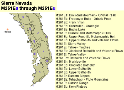
Subsections
The Sierra Nevada Section is divided into
21 subsections.
A Diamond Mountain - Crystal Peak
... the steeper parts of the Diamond Mountains and a high plateau adjacent to the Diamond Mountains.
B Fredonyer Butte - Grizzly Peak
... extends from the northern edge of the Sierra Nevada, which is along the Susan River, south to Grizzly Peak.
C Frenchman
... mostly Tertiary volcanic terrain north of Sierra Valley.
D Greenville - Graeagle
... extends from the northwestern edge of the Sierra Nevada, adjacent to Lake Almanor, along the Plumas Trough to Mohawk Valley.
E Bucks Lake
... the higher part of a granitic pluton and surrounding rocks in the vicinity of Bucks Lake.
F Granitic and Metamorphic Hills
... low to intermediate elevations of the western slope of the Sierra Nevada where it is crossed by the Feather and Yuba Rivers.
G Upper foothills Metamorphic Belt
... the intermediate elevations of the western slope of the Sierra Nevada where it is crossed by the Yuba, American, Cosumnes, ...
H Upper Batholith and Volcanic Flows
... moderately high elevations of the western slope of the Sierra Nevada. It is just west of a fault zone from Mohawk Valley, which is in the Plumas Trough, to Lake Tahoe; ...
I Sierra Valley
... comprises Sierra Valley, which is in the block-faulted part of the Sierra Nevada, at the head of the Middle Fork of the Feather River.
J Tahoe - Truckee
... near the southern end of the block-faulted northeastern part of the Sierra Nevada. It is between Sierra Valley and Lake Tahoe.
K Glaciated Batholith and Volcanic Flows
... along the crest of the Sierra Nevada from the Crystal Range southwest of Lake Tahoe to Kennedy Peak just south of Sonora Pass.
L Tahoe Valley
... a valley at the southern end of Lake Tahoe.
M Batholith and Volcanic Flows
... comprises the mid-elevations of the western slope of the Sierra Nevada between the American River and Merced River.
N Markleeville
... the mountainous terrain just east of the crest of the Sierra Nevada, from the south end of the Carson Range southeastward to the West Walker River near Antelope Peak.
O Glaciated Batholith
... the crest of the Sierra Nevada from Granite Dome just south of Sonora Pass southeast to Mt. Whitney.
P Lower Batholith
... comprises the mid-elevations of the western slope of the Sierra Nevada from El Portal on the Merced River southwest to the Greenhorn Mountains.
Q Upper Batholith
... the higher elevations of the western slope of the Sierra Nevada from the Grand Canyon of the Tuolumne River south-southwest to Slate Mountain, which is on the drainage divide west of the Kern River.
R Eastern Slopes
... the very steep eastern slope of the Sierra Nevada from Eagle Peak west of Bridgeport south to the Tehachapi Pass area. It includes South Fork Valley of the Kern River system, most of the Scodie (or Kiavah) Mountains, and Kelso Valley.
S Tehachapi - Piute Mountains
... the southern end of the Sierra Nevada. It includes most of the Tehachapi and Piute Mountains.
T Carson Range
This subsection is a mountain range east and northeast of lake Tahoe.
U Kern Plateau
... a high plateau west of the main crest of the Sierra Nevada. It is between the Kern Canyon Fault and the eastern slope of the Sierra Nevada from near Golden Trout Creek south to South Fork Valley.