Central - Soda Lake - Marl Springs

West -|- East
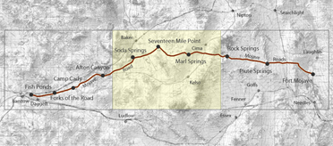
This central section of the Mojave Road ran between the Soda Lake basin and Marl Springs. It crossed country that could look open and easy from a distance, but was difficult for wagons, livestock, and travelers. The route passed over a dry lakebed, around low rocky hills, across gravelly fans and washes, and from one scarce water source to the next.
Soda Lake is a playa, the remnant of an ancient lake basin. In dry weather its surface can be hard and level, but rain can turn it into deep mud or standing water. The lake itself was not a dependable drinking source. Its water was alkaline, and travelers depended instead on nearby Soda Springs and other known water stops. The spring was warm, and in later years Soda Station served travelers using the old road. Hetzel was one of its operators.
The road east of Soda Lake did not always follow one exact track. Seasonal water, mud on the lakebed, wagon condition, and the needs of livestock could alter a party's course. Seventeen Mile Point was one of the named landmarks along this stretch, a place where the distance between water stops became very real. The surrounding country is typical Mojave Desert terrain: creosote flats, saltbush near the playa, scattered yucca, desert grasses, rocky washes, and low hills broken by erosion.
Marl Springs was the next major source of water to the east. Like the other springs on the road, it had long been known to Native travelers before the route became a wagon road. Mohave trade routes crossed the desert by linking water sources, and the later Mojave Road followed much of that older pattern.
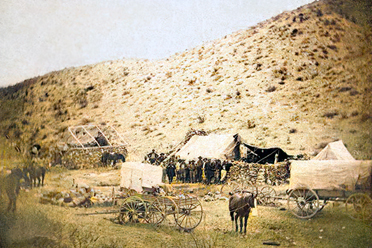
During the 1860s, the Army used this section to move mail, supplies, and escorts between Camp Cady and Fort Mojave. Marl Springs became an important military station in 1867, part of a chain of small posts intended to keep the road open and reduce the distance between relay stops. Orders from that period directed escorts to water and change horses at Soda Lake and Marl Springs.
This part of the road shows why the Mojave Road was never simply a line across a map. It was a practical route shaped by water, weather, distance, and the condition of the desert. Soda Lake, Seventeen Mile Point, and Marl Springs remain landmarks in that old pattern of desert travel.