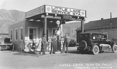
Little Lake is privately owned with no access to the public. Do not trespass.
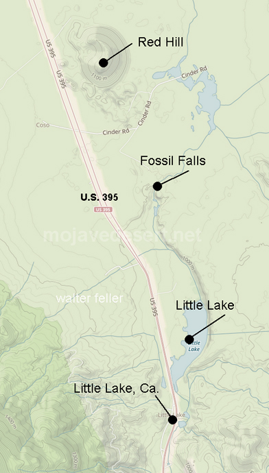
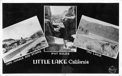
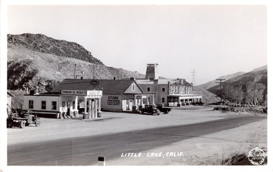
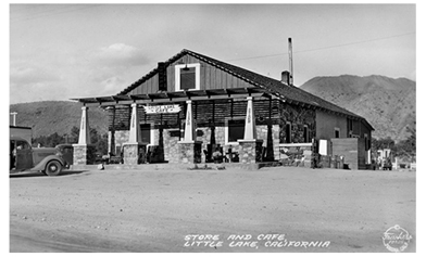
Little Lake
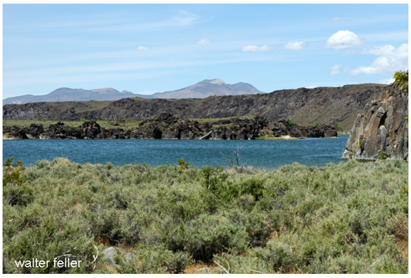
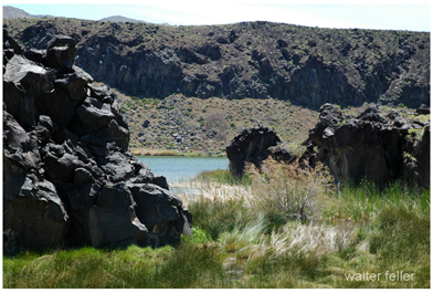
Litte Lake's shimmering waters have the same effect upon tired travelers journeying through arid Mojave desert land as had the swamps of a century ago upon plodding prospectors. Where wind-ruffled wavelets lap against basalt cliffs formed millenia ago when molten lava oozed down their dark flanks, gold-seeking Mexican miners once paused to refresh themselves at swamps they named Lagunita. This was the first water to be found within 20 miles after leaving the valley of the Indian Wells.
Following the discovery of precious metals, white miners, settlers and store-keepers risked Indian depredation to build up businesses that netted one merchant as much as 550,000 annually. It was during this period, in the mid-sixties, that the melodic name of Lagunita was changed to prosaic Little Lake, California.
From 1865 to 1883, Cerro Gordo's famous silver-lead mines kept southern roads bus) with freightwagons and Little Lake flourished as an important stage stop. With the waning of Cerro Gordo, however, road traffic began to slow. In 1910 the Southern Pacific Railroad came through Little Lake, giving Owens Valley its long coveted rail connection to the south. It was necessary to lay the rails upon trestles in order to "navigate" the tule swamps. At long last Little Lake the stage stop, became Little Lake the whistle stop.
In the early '20s, Bill Bramlette, a well-known auto racer of the era, saw Little Lake while participating in a load race from Los Angeles to Bishop. Envisioning possibilities in these swamps, he purchased various homesteads around the area, aggregating some 1200 acres. Then he settled down to raising cattle. He dammed up the south end of the swamps to irrigate his pasture lands and, to keep down the tule growth, he imported muskrats. The resultant mile-long lake, he stocked with fish. Very shortly afterwards delighted fishermen arrived from Southern California cities.
For years Bill Bramlette's son, Tom, and his family ran Little Lake as a fishing and boating resort. Tom put in two campgrounds at the north end of the lake, a snack bar and a trout rearing pond and rented boats. Fish are bluegill, bass, catfish, crappie and trout.
Today Little Lake is owned by the Jack Morehart Land Company of Los Angeles, but it has been subleased to Bob Whiting of the Mt. Whitney Game Club. Bob opened Little Lake to public fishing on May 16, 1964. Prices are reasonable. Boat rentals are S3.50 per day and fishing fees are $2.50 or, for children under 12, $1.50 per day. No license is required and there's no limit. One lucky fisherman recently came away with a catch of 40!
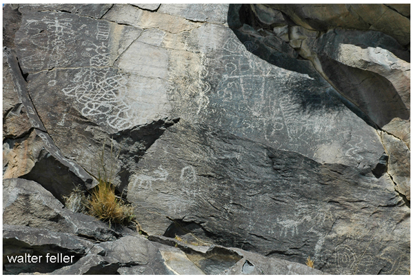
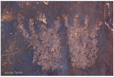
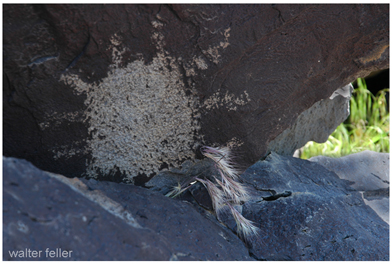
Petroglyphs near Little Lake
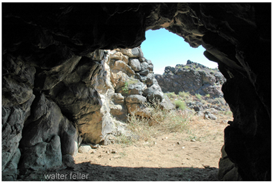
The campgrounds are in operation all of the time and on weekends and holidays a snack bar is open. These facilities are at the lake, but Little Lake hamlet lies a mile or so south where there is a large hotel with dining room, coffee shop and post office. In 1947 Little Lake became the scene of much archeological excitement when Duane and Margaret Mack of China Lake discovered a cave with a human skeleton which was later identified by Dr. M. R. Harrington of the Southwest Museum as that of a Pinto Man some 3000 years old!
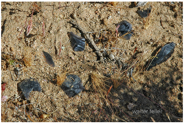
Debitage - Waste material produced in the making of prehistoric stone implements.
The Bramlettes had known for years that their property was once the site of an extensive Indian camp, but they attributed the artifacts to "modern" Indians. In 1948 the Southwest Museum began serious excavations of the Little Lake Pinto basin. Uncovered were house sites of a large prehistoric village with underlying layers holding stone implements, shell beads, hunting points and household tools.
The area's other points of interest are the Upper and Lower Fossil Falls. Lower Fossil Falls in on Little Lake property, but Upper Fossil Falls is on public domain. These fantastic lava flows were scoured and ground into potholes of every size and depth by the Owens Lake overflow thousands of years ago. To reach Upper Fossil Falls, drive two miles up the highway to a bright, orange-splashed boulder on the right side of the road. A half-mile drive brings you to the first road on your right, now turn south and go to the end. You will have a 3 mile hike over to the lip of the deep chasm, but watch your stepyou come to the edge suddenly. An easier way is to follow the red cinder road at the base of the Cinder Hill east until you come to a large dry lake on your right. Turn and follow the west side which angles southward. Follow the tracks that turn west again, for this leads you to the mesa which overlooks Little Lake canyon. You can't miss it, for the whole area glitters with obsidian chips brought down by the Indians from "glass" mountain, to the east. This ancient campsite holds a wondrous display of house circles and secluded rock shelters. It has caves and, if you are lucky, you may even find desert diamondsclear quartz and feldspar that have leached out from the basaltic rock. Cut and polished, these "diamonds" sparkle like dewdrops and make beautiful jewelry.
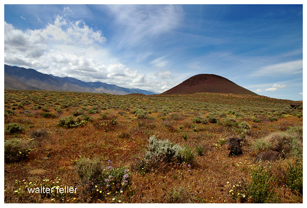
Red cinder hill
Strangely enough, although the busy highway is only a short distance westward, there is an illusion here of being in another age. The country is wild, rugged and arid, yet during spring and early summer it turns into a vivid patchwork of shining white pygmy poppy, blue desert lupine and glowing paintbrush. Here in this unspoiled region, within a safe distance from civilization for the timid, city-jaded travelers may hunt desert diamonds, wander in a prehistoric art gallery, fish, boat, or simply marvel at the frozen, swirling mass of California's geologic past.
from: LITTLE LAKE'S BIG FUN
by Dorothy Robertson
Desert Magazine - June 1965
Fossil Falls
U.S. 395
Southern Pacific Jawbone
Burton Frasher photos
Courtesy Susan Stanton