Introduction
Physiography
Weather Data
Geologic History
Changing Climates
Weathering & Erosion
Carbonate Rocks
Granitic Rocks
Volcanic Rocks
Faults
Pediments
Stream Channels
Stream Terraces
The Mojave River
Playas
Sand Dunes
Human Impacts
References
-.-
Stream Terraces and Older Surfaces
Stream terraces form when streams carve downward into their
floodplains, leaving discontinuous remnants of older floodplain surfaces
as step-like benches along the sides of the valley. Stream terraces are
common throughout the Western United States. In the context of this
discussion on the Mojave region, older surfaces represent flattened
areas (plateaus, mesa, uplands areas, hillside benches) that are stable or
isolated, neither experiencing significant rates of sediment buildup
(aggradation) or down cutting by erosion. These older surfaces may have no
clear or obvious connection to a more modern drainage system in a
particular area. Terraces and older surfaces preserve or display unique
characteristic soil profiles or weathering characteristics because of
their long-standing isolation from stream erosion.
Many factors influence why streams episodically carve into their
floodplains, forming stream terraces. Because stream terraces are
typically widely distributed along steams throughout a region, changing
climatic conditions are likely a most important contributing factor to
their formation. Streams broadened their floodplains when sediment
supplies are high and down cutting by stream erosion is abated. In cool,
wet periods, plants typically cover the landscape, and hence sediment
supply is low; enhanced moisture increases stream flows, and streams
draining mountainous regions will cut downward. During dry periods, plants
don't provide enough cover to prevent intense erosion during infrequent
storms. As a result, high sediment yields may result in the backfilling of
stream channels. This natural feedback system is much more complex than
this because many other processes occur simultaneously. Under cooler,
wetter conditions during an ice age, soil development and weathering
processes proceed faster due to more frequent wetting and drying, more
freeze-thaw cycles, and increased biological activity (particularly root
penetration). Soils formed during extended wet periods can be released as
sediments once the groundcover is removed during drought conditions,
especially by wildfire followed by a rainstorm.
Climate is also a factor in the development of caliche
(calcium-carbonate-rich crusts or soils that form in desert conditions).
In North America, caliche is found in arid or semiarid regions of the
western states. In many places in the Mojave region these
calcium-carbonate-rich crusts form a resistant caprock along stream
terraces.
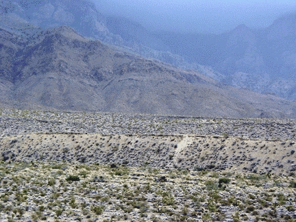
Caliche-cemented gravels (pale zone topped by a ledge) form the
resistant cap rock of older Pleistocene terrace surfaces along the
sides of the modern wash. In the distance, the surface of an older
quaternary alluvial fan is preserved intact (partly due to a
resistant caliche bed preserved at the surface). The high core of
the Providence Mountains in the distance consists mostly of
Paleozoic limestone and dolomite rock formations; these rocks
provide calcium carbonate to the alluvium and enhance caliche
development.
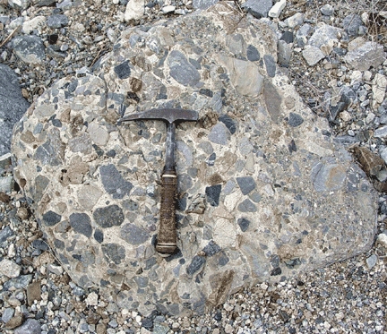
A boulder of the caliche-cemented gravel has been eroded and
re-deposited.. It displays rock fragments similar to the modern
stream gravels surrounding it.
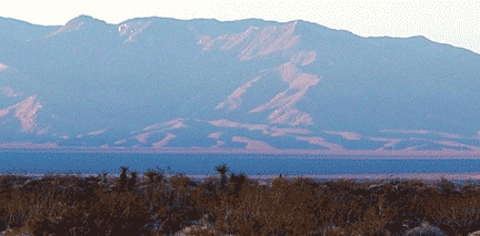
Morning sunlight highlights the incised remnants of an older
(Pleistocene or Pliocene) alluvial fan along the mountain front of
the Granite Mountains. The smoother modern (Holocene) alluvial fan
surface stands out in the foreground (in mountain shadows). The
incised and eroded condition of this fan suggests different
possibilities.
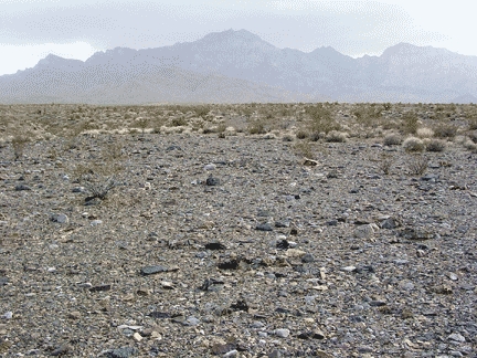
A desert pavement (a surface gravel deposit of tightly packed
pebbles, layered just one pebble thick and generally devoid of
vegetation) is abundant on Pleistocene-age surfaces, particularly in
the mid-fan regions. Pavements such as this occur in areas where the
stream flow is restricted to relatively stable channels nearby. Note
how little relief exists on this alluvial fan surface on the eastern
flank of the Providence Mountains.
A close-up view of a desert pavement shows that gaps between
rock fragments are small or rarely visible (hiding the accumulated
dust underneath). Wind and episodic rains keep the surface free of
dust, and plants have a difficult time becoming established due to
lack of soil. The surface temperature difference between night and
day during the summer may range over 100 degrees Fahrenheit. This
daily temperature difference may play a role in the formation of
these pediment surfaces. Most of the rock fragments shown here are
dolomite and limestone.
Next > The Mojave River and Associated Lakes