|
Digital-Desert :
Mojave Desert
|
| Intro:: Nature:: Map:: Parks:: Points of Interest:: Ghosts & Gold:: Communities:: Roads & Trails:: People & History:: BLOG:: Weather:: :?:: glossary |
|
|
Wilderness - MAP Bigelow Cholla >> Map #34 Bigelow Cholla Garden Wilderness MapSIZE: 10,380 acresLOCATION: San Bernardino County; 18 miles west of Needles, California
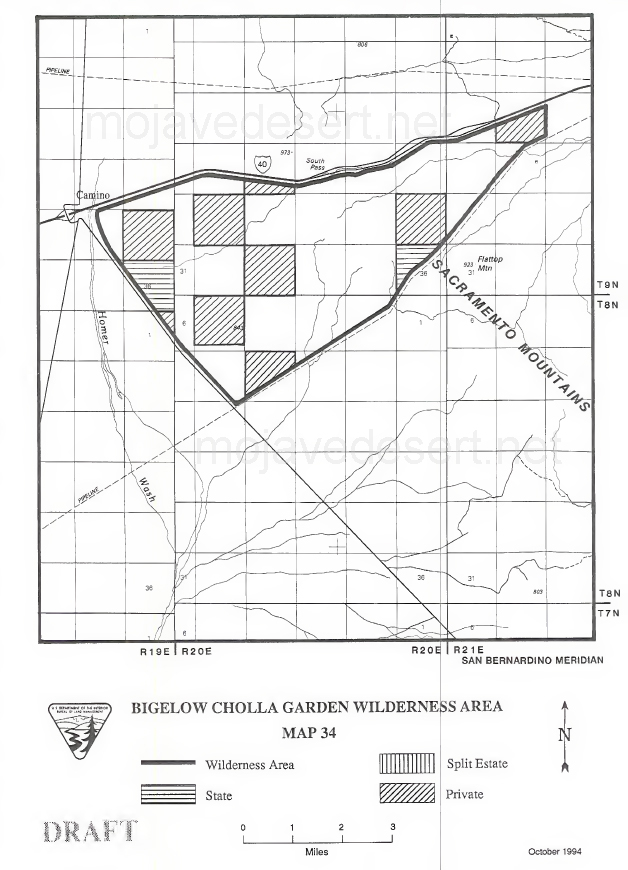
ACCESS: Interstate 40 forms the northern boundary of the wilderness. Exit U.S. Highway 95 from 1-40 and follow the dirt road south for about 200 feet. Turn right 180 degrees to access the Four Corners's Pipeline and travel west. The southern boundary, delineated by this road, begins in 3 miles. There are no established trailheads, and high clearance vehicles are recommended. |
| Intro:: Nature:: Map:: Parks:: Points of Interest:: Ghosts & Gold:: Communities:: Roads & Trails:: People & History:: BLOG:: Weather:: :?:: glossary |
|
Digital-Desert :
Mojave Desert
|
|
Country Life Realty Wrightwood, Ca. |
Mountain Hardware Wrightwood, Ca. |
Canyon Cartography |
G.A. Mercantile |
Grizzly Cafe Family Dining |
|
Abraxas Engineering privacy |
Disclaimer: Some portions of this project were developed with assistance from AI tools to help reconstruct historical contexts and fill informational gaps. All materials have been reviewed and fact-checked to ensure accuracy and reliability, though complete precision cannot be guaranteed. The aim is to provide dependable starting points and distinctive perspectives for further study, exploration, and research. These materials are historical in nature and intended for educational use only; they are not designed as travel guides or planning resources. Copyright - Walter Feller. 1995-2025. All rights reserved. |