Impassable Pass - Spanish Canyon

Spanish Canyon
Trails Converge: The Fork of Roads and Impassable Pass
For travelers making their way across the Mojave Desert, the journey was dictated by water sources, passable terrain, and the routes carved by those who came before. One of the most significant junctures in this arid expanse was the Fork of Roads, where multiple historic trails merged to follow the Mojave River westward. This natural confluence of pathways, shaped by both necessity and opportunity, connected early explorers, traders, emigrants, and military expeditions as they navigated the desert.
The Route to the Fork of Roads
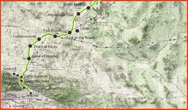
The journey to the Fork of Roads was not an easy one. Travelers often approached from the east, having successfully crossed Red Pass, a rugged and steep section of trail that offered a formidable test of endurance. After descending from Red Pass, water awaited at Bitter Springs, a critical desert waterhole that had served indigenous peoples and later travelers for generations. From there, emigrants and traders set their sights on the convergence point of the Mojave Road, the Armijo Route, the Northern Route, and, later, the Mormon Road.
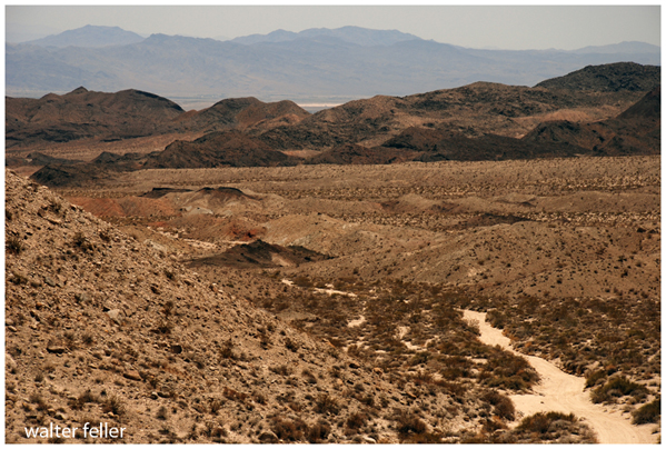
Once at the Fork of Roads, the choice was clear: follow the course of the Mojave River westward. The river was the region's most reliable water source, making it a vital guide for those pressing onward toward the Cajon Pass and beyond. However, before reaching the river's banks, travelers had to navigate a difficult stretch of terrain through the Alvord Mountains and down Spanish Canyon.
The Challenge of Impassable Pass
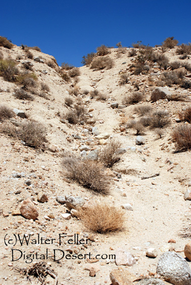
One of the most striking features along this historic route is a place known locally as Impassable Pass. This segment of the trail marks the boundary of the modern Fort Irwin Army Training Grounds and is characterized by deep ruts carved by decades of wagon travel. At its apex, a series of large boulders have been deliberately placed to prevent modern vehicular access, turning the already difficult passage into a nearly insurmountable barrier.
Though no official records explain the placement of these boulders, some speculate they were installed by government agencies to prevent unauthorized entry onto military land, while others believe they may have been positioned by off-road enthusiasts to deter vehicle traffic from damaging the historic trail. Whatever their origin, the result is a stretch of trail that remains largely untouched by modern intrusion, preserving the landscape much as it appeared to travelers over a century ago.
Echoes of the Past: Signal Fires and Desert Landmarks
Just beyond Impassable Pass, remnants of the past still whisper to those who pass through. A circular rock formation at the top of the pass is believed to be the remains of a signal fire ring used by Mormon pioneers. Such fire rings were strategically placed along desert trails to communicate messages across vast distances, warning of dangers ahead or signaling the presence of fellow travelers.
From the summit of Impassable Pass, long-distance views stretch across the desert, offering a panoramic glimpse into the same vast landscape that once tested the endurance of early travelers. Those who stand at this vantage point today can see the same undeveloped terrain that has remained virtually unchanged since the days when wagon wheels cut their deep impressions into the earth.
A Trail Preserved in Time
Unlike many historic trails that have been paved over, rerouted, or erased by modern development, this section of the Mojave Road and its associated trails remain remarkably well preserved. With almost no modern intrusions, travelers can still see the evidence of those who came before: the ruts, the fire rings, the well-worn paths through the sand. For those who seek to understand the hardships and triumphs of desert travel, few places offer a more authentic experience.
The Fork of Roads and Impassable Pass stand as silent witnesses to the generations of travelers who braved the harsh Mojave landscape. Whether they came in search of trade, opportunity, or a path to a better life, they left behind more than just wagon ruts they left a trail of history, waiting to be rediscovered.

 Impassable Pass