Saratoga Springs
FS2. Location/Access:(35o 40.868N, 116o 25.310W) Saratoga Springs is located about 3½ miles northwest of Site FS1 (the crossing of the Amargosa River) or about 4 miles northwest of the Saratoga Springs turnoff from the Harry Wade Road. As you head north from the Harry Wade Road, you will cross several small dry channels of the Amargosa River. The northerly track of the excellent gravel road ends at a T-type intersection. The left fork is signed and heads to Saratoga Springs. This section of road may be muddy after rain.
Best Time: Late morning in the cool half of the year.
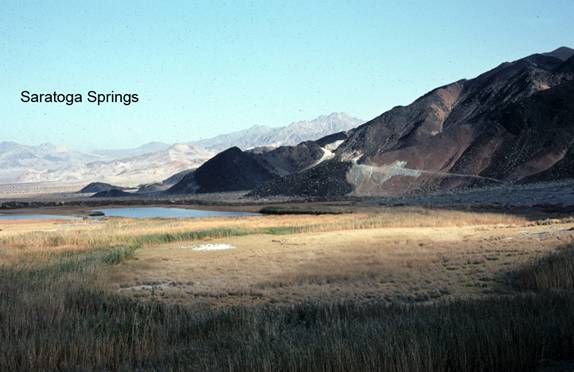
Geology: Saratoga Springs is probably the best spring in Death Valley. The large pools are partially the result of talc miners adding a berm (probably in the 1950s) but all of the buildings and non-native vegetation were removed by the early 1970s. The flow of the springs was once measured to be 48,000 liters per day (Robinson, 1957). The flow of underground water in the Death Valley-southwest Nevada region is very complex, but with the large quantities of fractured limestone, faults and gravel-filled basins, long distance migration of groundwater is quite possible. As Death Valley is the lowest land around and Saratoga Springs is at the bottom of the southern end of the valley with the geologic requisites mentioned above, its existence should not be a surprise. The ponds are the home of a species of pupfish, Cyprinodon saratogensis (Miller, 1950). The existence of these small fish (Brown, 1971) in diverse localities throughout the Death Valley region establishes both dramatic recent climate change and the existence of a significant system of desert lakes and rivers that were present as recently as the most recent glacial maximum approximately 18,000 years ago. However, the fish found here and in Salt Creek and Devil's Hole have speciated since their respective isolation. Recent data (Knott, et. al., 2008) establishes that divergence of the species may have begun in the mid-Pliocene and at that time Death Valley was not connected to either the Mojave or Amargosa Rivers. The springs were a major locus of talc mining after World War Two (Wright, 1950). This is one of the best places to closely examine the 1.08 billion-year-old diabase sills (Heamon & Grotzinger, 1992) and the Crystal Spring formation. The best access is just northeast of the large ponds, a very short hike from the parking area.
Saratoga Springs
Several springs feed three large open water ponds approximately ...Amargosa River
The Amargosa River originates in the mountains surrounding Beatty, Nevada, flows through the Amargosa Desert region, and terminates at ...Changing Climates and Ancient Lakes
The impact of both long-term and short-term climatic oscillations can be seen on the landscape. Glaciation periods ...Salt Creek
At the bottom of Cottonball Basin runs Salt Creek, home of the rare Salt Creek Pupfish. ...Mojave River & Associated Lakes
The Mojave River is the largest drainage system in the Mojave Desert. It's modern extent and capacity is only a fraction compared to ...=-=