Digital-Desert : Mojave Desert
Intro:: Nature:: Map:: Parks:: Points of Interest:: Ghosts & Gold:: Communities:: Roads & Trails:: People & History:: Weather:: :?:: glossary

--
Death Valley National Park: Backcountry Roads:

Cottonwood and Marble Canyons

Route #9
    Vehicle needed:
    high-clearance first 8 miles, 4x4 recommended beyond

    Distance:
    13 miles Marble Canyon; 16 miles Cottonwood Canyon

    Start:
    east of the Stovepipe Wells airstrip

    Camping:
    yes, after first 8 miles

    Description:
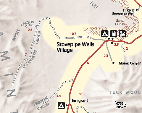
    For the first 8 miles, the road crosses Mesquite Flat and climbs a broad alluvial fan before reaching the canyon mouth. The road drops into the wash and becomes rocky and rough. One mile past the end of the first narrows, a side road leads up to Marble Canyon. Hikers can continue up the canyon beyond road’s end to see some of the finest canyon narrows in the park. Two miles beyond road's end up Cottonwood Canyon is a flowing stream lined with cottonwood trees.

Cottonwood-Marble Canyon Loop Hike

Below the spring, trees line a small stream but brush can be ...

Geology

    Mouth

    The folding of the sedimentary rocks at the south end of the Grapevine Mountains is more obvious ...

    Cave

    This is a quite unusual cave as it does not have a ...

    Megabreccia

    The limestone was being pulled apart as groundwater precipitated travertine around the ...

    Faults/Springs/Deposits

    At this location, there is a great deal of white travertine on the north ...
Intro:: Nature:: Map:: Parks:: Points of Interest:: Ghosts & Gold:: Communities:: Roads & Trails:: People & History:: Weather:: :?:: glossary
Country Life Realty
Wrightwood, Ca.
Mountain Hardware
Wrightwood, Ca.
Canyon Cartography
DesertLink
Links to Desert Museums

Grizzly Cafe
Family Dining

Custom Search

Abraxas Engineering
privacy
These items are historical in scope and are intended for educational purposes only; they are not meant as an aid for travel planning.
Copyright ©Walter Feller. 1995-2024 - All rights reserved.