A Major Variation of the Old Spanish Trail
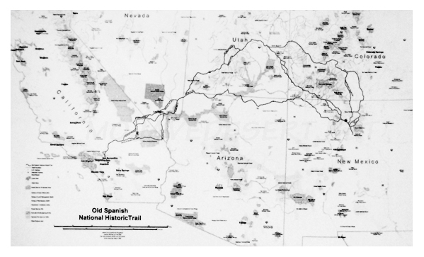
A major variation of the Old Spanish Trail was established by traders and trappers using American Indian and Spanish colonial routes from Santa Fe and Taos into the San Luis Valley of Colorado, and then west to Cochetopa Pass and the Gunnison River Valley. It provided a corridor into eastern Utah. The route through the San Luis Valley included the main road from Taos and also a western fork that came into greater use after 1848. These trails collectively formed a route that became known as the North Branch of the Old Spanish Trail. In his 1870 book about life in the West, John C. Van Tramp cites a letter he received from trapper, Antoine Leroux. Leroux identifies the North Branch as an alternate route to California from Taos. Its greatest attraction to the trail travelers was the Cochetopa
Pass. Leroux reported that There is not much snow in this pass, (the Coochetope,) and people go through it all the winter. And when there is much snow on the mountains on the Abiquiu route, (which is the old Spanish trail from Santa Fe to California,) the people of Taos go round this way, and get into that trail in the forks of the Grand and Green rivers.
As use of Old Spanish Trail segments continued, travelers established numerous other variations to take advantage of better water sources and to shorten the length and time of travel. By 1848, travelers had developed several variations of the route to the Sevier River in order to avoid the Sawtooth Narrows of Salina Canyon. Another variation, developed later still, was the Kingston Cutoff, which led travelers southwest from Mountain Springs, Nevada, to Silurian Lake, California.
As the trail network evolved, partly from indigenous footpaths and partly from newly blazed routes, into a horse and mule trail, and later into a wagon road, several variants were opened through Cajon Pass, north of San Bernardino. Some traffic went over Cajon Pass following what is now California State Highway 152 up to the summit, and descended into the San Bernardino Valley through the area now occupied by the California State University campus. However, the route chosen probably depended on several factors, including party composition, the amount and type of load carried, whether weather was wet or dry, the time of year, and the presence of government inspectors.
Previous - Next
About the Old Spanish Trail
American Indian groups
Spanish colonial interest
In late summer of 1826
A major variation of the Old Spanish Trail
The major reason for travel
There was considerable legal trade
Some of the vast fur trade
Hispanic New Mexican families
Americans and other foreigners
With the American takeover of California
Over the years a number of military groups
Overall, use of the Old Spanish Trail