Mojave Road in 1863
photos by Rudolph D'Heureuse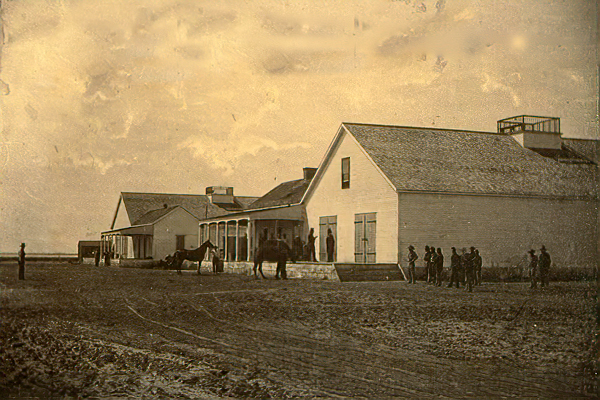
Drum Barracks - 1863
In 1863, photographer Rudolph DHeureuse produced a series of photographs now preserved as Photographic Views of the Mojave Route, El Dorado Canyon and Fort Mojave (Bancroft Library, UC Berkeley). The collection contains 41 photographs (with a physical extent of 44 prints, reflecting mounted duplicates) and documents the corridor from the San Bernardino Valley and Cajon Pass eastward across the Mojave Desert to the Colorado River and Fort Mojave.
Why DHeureuse undertook this work is not definitively known, but the Bancroft guide suggests he was likely surveying in connection with either the Macedonia Mining District or the California State Geological Survey. The photographs emphasize geological and botanical featuresvalleys, hills, mountains, plains, canyons, and characteristic desert plants (notably cacti and yucca)while also capturing people (surveyors, soldiers, and Native individuals) and material traces of travel such as camps, dwellings, and other structures.
Provenance note
The finding aid records that William Henry Brewer (California State Geological Survey) obtained the photographs from DHeureuse in 1869 and listed them in his fieldbook, with the collections numbering reflecting Brewers list (including missing numbers). The guide was later revised (2018) using research published by Jeff Lapides and Dennis G. Casebier.
The Photographic Views of the Mojave Route, El Dorado Canyon and Fort Mojave collection contains photographic prints taken by Rudolph D'Heureuse in 1863. Pictured in the collection is the Mojave Desert region from the San Bernardino Valley and Cajon Pass eastward to the Colorado River and Fort Mojave of Arizona. The reason D'Heureuse photographed this section of the "Mojave Road" and the adjacent region is unclear. It is most likely that he was surveying the area in association with either the Macedonia Mining District or the California State Geological Survey. D'Heureuse's work is considered to be the earliest extant body of survey photographs of this region.
UC Berkeley, Bancroft Library