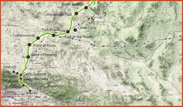
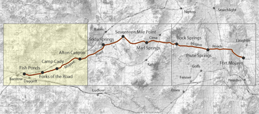
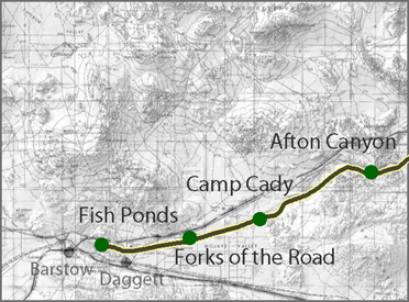
Camp Cady
(1860 - 1871)
Camp Cady looks the same as everything around it. The earliest post has largely vanished from the ground, and local accounts credit the March 1938 flood with removing the adobe traces that once made the place legible. What remains is fragmentaryruins associated with later ranch use, a hospital spot remembered by rock alignmentsand a broad, bright floodplain that gives you more sky than shelter.
That sense of absence is part of the corridor's longer rhythm. Decades before the Army ever laid out a parade ground here, John C. Frémont used this reach of the Mojave River in 1844 as a practical staging point before pushing into harsher country. The story, as preserved in local summaries, is bluntly utilitarian: tired cattle were slaughtered and jerked for meat, and travelers carried newstwo Mexican refugees reportedly described an ambush at Resting Springs up on the Las VegasSalt Lake line. Even in the 1840s, this was already a place where water, travel, and intelligence naturally collected.
The Armys decision to plant Camp Cady here follows that old desert logic. In 1860, amid increasing tensions and attacks along the Mojave Road corridor, Major James Henry Carletons field operations necessitated construction of a base camp, and the National Park Service account states he completed Camp Cady in May 1860, then abandoned it in early July after issuing terms of peace. Before withdrawing, his command also built unmanned redoubts at key water stopspractical refuges meant to shelter men, animals, and wagons on a route where help could be a long day away.
Californias landmark text and later summaries help you see what kind of post this was: a two-road protection node. The marker language explicitly ties Camp Cady to the Mojave Road and the nearby Salt Lake Road/Salt Lake Trail, and describes the main building as a stout mud redoubtdesert engineering suited to a country with little timber and lots of sun-dried soil. Thats the corridor spine function in plain words: hold a key water reach, protect two lines of movement, and keep the mails and freight from being choked off.
If you want a snapshot of a period, the photography matters. A well-documented photographic record of the Mojave River route begins with Richard DHeureuse, who accompanied a California Geological Survey expedition in 1863 and produced a substantial set of images along the Mojave River route toward Fort Mojave. Local Camp Cady write-ups also note that the original fortress stood next to Government Road and was photographed in the 1860san unusually concrete visual anchor for a place whose built fabric is mostly gone today.
By the mid-1860s, Camp Cadys importance sharpens again, and the official NPS narrative supplies the larger reason: after Fort Mohave was reoccupied in 1863, the 2nd California Cavalry moved to Camp Cady under orders to protect travelers and clear the road, and between 1864 and 1867, the Mojave Road served as the primary mail route between California and Prescott. In June 1866, the Army re-garrisoned Camp Cady specifically to secure the road as a mail route; the July 29, 1866, fight noted in the same account shows just how quickly a thin garrison could be pulled into violent escalation.
Yet the best human texture comes from the unromantic paperwork and camp gossip that survived. An 1866 Army inspector, quoted in local summaries, looked at the place and concluded, There is little probability of the post being long occupied. He found three officers and 63 enlisted men and noted efforts to reduce the garrison to a token force to preserve buildings and supplies as they moved toward Arizona. He also observed the sheer friction cost of desert logisticscattle purchased at Wilmington arrived dramatically lighter after the drive, causing a recommendation to increase meat rations. Even the posts finances sounded spare: the quartermasters lack of outstanding debts was fortunate, but it helped that he reportedly had only $2.50 on hand.
Daily life at Camp Cady shows the Armys old habit of fighting chaos with routine. Reveille before dawn, an early breakfast, drill, then work detailsfollowed by a long heat break when temperatures pushed into the extremes (local accounts cite 118°F), then the day tightened again toward taps. Its easy to admire the discipline and still recognize the cost: monotony, confinement, and the psychological grind of doing the same small duties in a vast, empty country. Those same accounts describe a guardhouse kept full, desertion even among seasoned men, and incidents of violence and disorder that could severely weaken an already tiny garrison.
Camp Cadys later arc closes in the familiar way many desert corridors do: the landscape asserts itself, and the traffic patterns move. The NPS account notes massive flooding in the winter of 186768 that inundated out sections of the Mojave Road and contributed to the routes decline. The state landmark text adds the structural footnote: improved camp structures were built about a half mile west in 1868, and the Army withdrew in 1871.
Underneath all of this is the physical reason the node exists at all. USGS describes how, where the Mojave River approaches the northwest side of the Cady Mountains, the channel appears to cross a subsurface geologic structure that forces groundwater toward the surfacesupporting a well-established riparian zone of mesquite, cottonwood, and Goodding willow (documented in 1917). Thats the old order of the desert: water concentrates, routes converge, and human institutionsmail lines, escorts, outpostsstack themselves on top of the same dependable strip of life.
Salt Lake Road/Old Spanish Trail
History of Camp Cady
Chronology of Camp Cady
Mojave Road 1863Also see:
Military in the Mojave
People in the Mojave
Native Culture
Roads & Trails
Mojave Desert Rivers
Desert Habitats: