Digital-Desert : Mojave Desert Visit us on Facebook -- Desert Gazette -- Desert Link
Intro:: Nature:: Map:: Points of Interest:: Roads & Trails:: People & History:: Ghosts & Gold:: Communities:: BLOG:: Weather:: :?:: glossary
Arizona Mojave Desert

Boundary Cone Butte

Boundary Cone on Route 66 near Oatman, Az
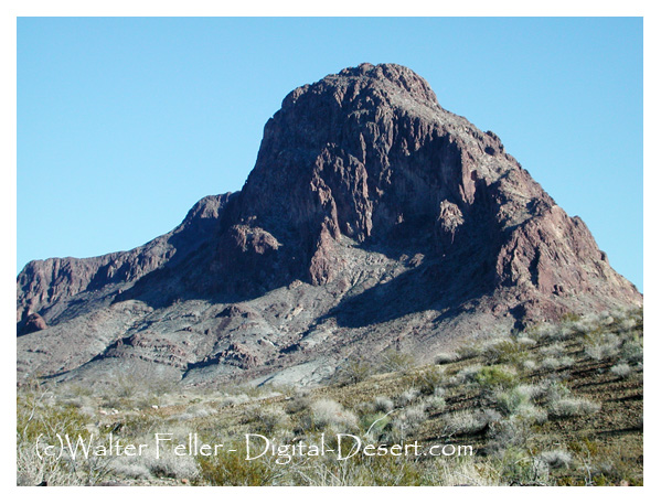
Boundary Cone Butte is a geologic promontory located in the western foothills of the Black Mountain Range on the Historic Route 66 between Needles, California and Oatman, Arizona, about 14 miles east of the Colorado River. Elevation 3429'.

This was a prominent landmark to pioneers traveling through the area. Several Indian tribes attach religious and cultural significance to the butte as well as much of the surrounding landscape, the most local being the Mojave Indians.

(ACHP - Advisory Council on Historic Preservation)

Elevation 3,430 ft
Volcanic neck

Mohave County, Az.

4 miles south of Oatman
12 East of Bullhead City


Intro:: Nature:: Map:: Points of Interest:: Roads & Trails:: People & History:: Ghosts & Gold:: Communities:: BLOG:: Weather:: :?:: glossary
Country Life Realty
Wrightwood, Ca.
Mountain Hardware
Wrightwood, Ca.
Canyon Cartography
DesertLink
Links to Desert Museums

Grizzly Cafe
Family Dining


Custom Search

AbeBooks
Abraxas Engineering
privacy
These items are historical in scope and are intended for educational purposes only; they are not meant as an aid for travel planning.
Copyright ©Walter Feller. 1995-2023 - All rights reserved.
3266