Route 12
Buttermilk Country
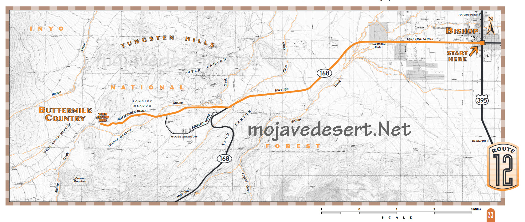
A lovely surprise tucked into the base of the Sierra near Bishop, the picturesque boulders of the Buttermilk Country are superb year-round but unsurpassed in late spring and early summer when the air is full of birdsong and the scent of wildflowers.What to expect: Begins on a paved highway, then follows a wide, short, rough and bumpy graded dirt road.
Length: 10.9 miles one way.
Driving time: about 45 minutes, one way.
Getting there: From Bishop starting at the corner of Main and Line, also known as highways 395 and 168, go west 7.3 miles. Highway 168 leaves town and climbs toward the Sierra. Look for Buttermilk Road on your right.
Along the route: Buttermilk Road crosses a cattle guard and turns to dirt immediately after leaving the highway. Stay on the main, wide, graded dirt road. At three miles youll climb a small hill, and after another half mile youll reach another cattle guard and the end of the route (after this the road becomes extremely rough). Thats all there is to it! Stop along the way, explore, climb and play.
The Buttermilk Country was named in the 1870s when Old Joe Inmanfather of the state senatoroperated a dairy here. Workers from a nearby sawmill would stop on hot summer days for a drink of cold buttermilk.
To the north are the Tungsten Hills, named for their main mining product. To the northeast, prominent on the Sierra skyline, is huge, almost triangular Mt. Tom site of the Pine Creek Mine, once the largest tungsten producer in the United States.
The willow-lined stream winding through the Buttermilks has, from about May through July, one of the richest populations of breeding songbirds in the Eastern Sierra. Among the most colorful birds found nesting here are black-chinned hummingbirds, green-tailed towhees, red-breasted sapsuckers and yellow warblers. Others are more subtle in color but dazzling in song: American robin, Bewicks wren, house wren, Brewers sparrow, fox sparrow and warbling vireo. And some, like the black-headed grosbeak, are strikingly handsome and incomparable musicians as well.
In spring you may find desert peach in bloom. The shrubs can be identified even when leafless by their smooth, spiny, purplish-gray wood. In spring the leaf buds open along with pink blossoms that fill their surroundings with a jasmine-like scent. Small, fuzzy, bitter peaches develop as summer progresses. Bitterbrush, a member of the rose family which keeps its tiny, three-lobed, dark green leaves year-round, sometimes produces wonderful displays of yellow blossoms with a spicy fragrance in late spring.
Tender young shoots of bitterbrush are an important food for a large herd of mule deer that comes down from the snowy high country to spend the winter in this area. And the deer, in turn, are food for mountain lions. An important reminder: dont allow small children to wander off alone in mountain lion habitat!
But do allow childrenand adults, yourself includedto clamber on the irresistible rock formations that fill this hidden valley. Legendary early Sierra climbers like Smoke Blanchard would take time off from cliffs and bolts and ropes to enjoy a day of Buttermilking. They were pioneering the popular sport now known as bouldering, and the Buttermilks are still among the finest places for the art of using natural finger and toeholds on rocks within jumping-off distance of the ground. Problems in the Buttermilks range from sloping scrambles almost any kid can do, to walls and overhangs that challenge the strength and agility of the greatest bouldering experts.
.. Source - BLM

Buttermilk Country