Chapter I
Some Geological Facts
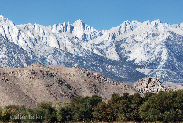
Mt. Whitney & Alabama Hills
No other equal area on this continent, probably no other on the earth's surface, equals Inyo county in diversified topography; for while Mt. Whitney, elevation 14,501 feet, highest peak of the States, stands on its western border, Death Valley, lowest of American land depressions, 427 feet below sea level, is also within its boundaries. Nature has written here, in bold strokes, studies more fascinating than the little affairs of humanity. It is worth while to glance briefly at what leading American geologists have deduced, and what they say of the making of this county of ours. Because we are doing so, and giving some attention to a few topics not strictly historical, this is "The Story of Inyo" rather than its history alone.
An English geologist once declared the Alabama hills, near the base of the Sierras in southern Owens Valley, to be the oldest mountains on the continent. This has been so often accepted and repeated as fact that it should be set right. George Otis Smith, Director of the Geological Survey, pronounced the assertion to be wholly erroneous. He declared that while presumably some Archaean rocks are exposed in the Alabama Hills, their elevation above the water is a comparatively recent geologic event.
"Recent" in this connection is a vague term, as we understand time. One geologist writes that "the million of years will remain the time unit." Scientists guess the earth's age all the way from 20,000,000 to 90,000,000 years. So when the elevation of the Alabamas, or any other occurrence, is credited to the "recent" geologic past it means a period of unknown remoteness. One who has examined this region says its successive events cannot be guessed even by ages.
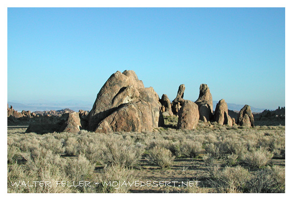
Alabama Hills
At the end of the Paleozoic period of worldbuilding, an immense inland sea, comparable with the Mediterranean of the present, covered what we know as the Great Basin. Probably while other ranges to the eastward were forming, the Inyo Range and White Mountains (now usually considered as one range) arose, with a division between them, east of where Big Pine now is. Westerly, a plain sloped to the Pacific. A later convulsion of nature produced the Sierras; and Mt. Whitney's site and surroundings, previously a region of gentle slopes and lowlands, were elevated to their present or greater heights. Intense volcanic activity prevailed, of which abundant evidences appear in the Whitney country as well as many other places along the Sierras.
The inland sea rose and fell many times. Geologist J. E. Spurr traced, in the Death Valley region, seven different changes of surface and periods of volcanic action. The glacial coating came along, and to this at least one investigator definitely assigns a time 80,000 years ago. Eemnants of the ice capping, melted in the valleys and fed by streams from the mountains, formed four great lakes between the Rockies and the Sierra Nevadas. One of these was Lahontan, remnants of which are Walker Lake and other Nevada waters. Another filled Death Valley, Owens Valley and the Mojave desert. These evaporated in the course of time, leaving beds of precipitated salts in the deserts, and Owens Lake in Owens Valley.
C. D. Avalcott, former Director of the Geological Survey, gave the name of ''Waucobi" to the Owens Valley lake, apparently taking this title from an Indian word more commonly spelled "Waucoba." Traces of this lake are found along the White Mountains. Walcott determined, by the character of fossils and shells found along the mountain side up to an altitude of 3,000 feet above the valley's floor, that it was fresh water. He dismissed the theory that the lake was 3,000 feet in depth, because there is no indication of any sufficient southern boundary. He believes, as do others who theorize on the matter, that the later rise of land between the two sections now combined in the White Mountain range carried the old shore up with it.
Bishop, Ca.
Volcanic action in the region is characterized as "very recent," which in this case may mean not a great many centuries. Two periods of volcanic activity are indicated. The later of these formed crater and cinder cones along the west side of Owens Valley, from Red Hill, near Bishop, to the lava beds of the middle part of the valley possibly at or not far from the time when the mud flowed forth and formed the mesa north of Bishop, and the craters northward as far as Mono Lake Basin were active.
Proof that the layman can appreciate that volcanic periods came at widely separated intervals was disclosed in artesian borings near Big Pine. Lava was encountered at more than 100 feet depth, under alluvial soil, while not far away the products of comparatively recent eruptions strewed the present-day surface. Whoever can figure how long it took for the valley to be filled that hundred feet can guess the least time that passed between those two outpourings of molten matter.
Evidences are that the mountains originally towered far higher above the valleys, Owens particularly, than at present. Whitney's pinnacle was higher above sea level, and has worn and broken away. On the other hand the valley floor was once much below what it now is. Borings to a depth of more than 1,000 feet, south of Owens Lake, penetrated only sedimentary gravels and soils. At the lake, deep borings cut successive layers of gravel, sand, volcanic ash, and gravel. Near Big Pine, a 576-foot well encountered only clay and fine sand, in several alternations. It is clear that the valley has been filling for untold ages. Some investigators claim nevertheless that the general level, at some remote period, was some hundreds of feet higher, and that it was dropped by a great earth-change.
Willard D. Johnson, who spent months examining geologic details of Owens Valley, wrote of it thus:
"Owens Valley had a lively history in the recent geologic past. The mountain-making forces have been extraordinarily vigorous. For example, the broad embayment in the Inyo Range, opposite Big Pine, has been lifted at least 1800 feet, possibly 3000, since glacial times. The Black Canyon region was lifted nearly as much. This great deformation was local, dying out rapidly from Black Canyon northward, and south- ward from Waucoba canyon. But the Bishop lava field, which had been spread only a little earlier, was warped, folded and shattered in an extraordinary manner. The display of faulting effects has no parallel elsewhere that I know of.
"In volcanism, cones are built by explosive eruption of molten lava. The coarser particles fall back vertically, to build the cone: the finer particles are drifted far on the wind, to fall as ash deposits. With excess of water and less heat, the steam-expanded lava is welled out and spreads as 'lava flows.' Owens Valley has record of volcanism of all types. There have been many ash showers; in the Black Canyon section many are preserved and exposed, one of which is five feet thick. There have been many cinder cones. Most of these have been in large part washed away, but several re- main, and some miles south of Big Pine one stands nearly perfect, embraced by glacial moraines, in evidence of postglacial, or 'recent,' volcanism. Rude cones of built-up lava flows are numerous. The largest is the black mountain im mediately south of Big Pine, There are at least a dozen others. Flows of molten lava cover large areas."
In some time of the far past, Owens Valley was larger than at present, for a mighty spread of volcanic matter now deeply covers its northern end, north of Owens River. A mesa of many square miles is full of such evidence. The gorge of Owens River, eroded to more than 800 feet depth, in places, below the general level, with vertical cliff walls of over 400 feet, discloses only an unvarying tufa mass.
Mr. Johnson wrote of the river gorge:
"For six miles it has a remarkably straight course. Has the river, in cutting its course, followed an earthquake crack 1 There is some reason to think so. This long section is not only exceptionally straight, but it runs at a considerable angle across the general slope of the lava plain surface. That is, fill the canyon and turn the river upon its surface above the Mono power intake and it would discharge into Round Valley. Furthermore, the lava plain is extensively faulted, in two systems of breaks approximately parallel. On the other hand, none of the recognizable faults parallel this long stretch of canyon. There are old river courses on the lava surface. There is evidence, finally, that the river took the long six-mile course following a tilting of pronounced grade in that direction. After it had cut down enough of a canyon to hold it, another tilt toward Round Valley occurred. "The really striking physiographic fact of this region, however, receives no comment. It is Birehim Canyon. Rock Creek cuts a deep canyon across a rising slope, in order to become a tributaiy to Owens River. If Birehim Canyon were filled, Rock Creek would pond up, only a few feet deep, and pass easily around the south end of the lava-plain slope. What deflected it in this unnatural way? Early heavy glaciation, which, filling Round Valley in large part, crowded Rock Creek aside, up-grade, and then left it permanently intrenched."Willis T. Lee, of the United States Geological Survey, remarks:
"The present form of the Owens River system is due largely to change of climate in recent geologic time. Throughout a part, at least, of Quaternary time Owens River flowed southward through Salt Wells Valley, and the portion of Owens Valley north of Bishop probably contained a flowing stream. During the changes toward greater aridity of climate which took place later, the water supply was cut off from the upper part of Owens River and one of its main tributaries was left as the head of the stream. At the time evaporation in the valley equalled or exceeded the inflow, that part of the river south of Owens Lake ceased to flow, and the tributaries from the White Mountains became dry from lack of sufficient rainfall, if indeed they had been permanent streams." Johnson concluded that many of the great natural changes here mentioned happened but yesterday, so to speak, in the world's making. He believed that they occurred
"since man made pictures of the hairy mammoth and other mammals belonging to glacial times on the walls of caverns in southeni France. While, say, the valley of the Euphrates has been standing still, and while on its plains of silt myriads of human beings have time and again busied themselves in erecting brick temples on the moulded ruins of uncounted other brick temples, Owens Valley has been in the making."
MOST DIVERSIFIED TOPOGRAPHY IN THE UNITED STATES ALABAMA HILLS NOT THE OLDEST AMERICAN MOUNTAINS-A MILLION YEARS THE TIME UNIT-CHANGES OF SURFACE-LAKE WAUCOBI-VOLCANIC ACTION IN DIFFERENT AGES-FORMATION OF OWENS RIVER GORGE.
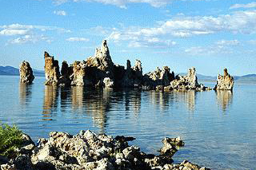
Mono Lake