San Bernardino-Panamint Road
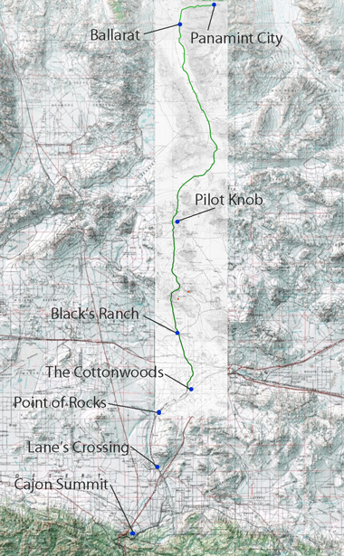
(Nadeau Cut-Off, Meyerstein's Road)Cut-off known by 1886 (cf. Lehman) between Cajon Pass and Stoddard's Well Road. Not referred to in any other publication thus far discovered by authors. No map identified this route. Rueger ' s 1903 auto map and Thurston's 1919 auto map show clearly, less used cut-off between the Pass and Victorville which connect with the Stoddard's Well Road, shortening the distance of the usual route west of these trails. This may be the Nadeau Cut-Off.
Nadeau was a freighter from Los Angeles who was mainly involved in delivering the bullion from the Panamint City mines in the Panamint Range to the Los Angeles market. When these mines opened in the 1870' s, the first supplier of goods to the camps was a Meyerstein of San Bernardino; later Nadeau entered the commerce and a road was constructed from Los Angeles via Tejon Pass to accommodate the needs of this high volume of traffic. This route from San Bernardino apparently was later called a "cut-off" to the better used wagon road, despite its separately conceived construction and location, and that Nadeau did not construct or use it. Meyerstein or Panamint Road can be traced from the 1903 Rueger auto map. Stops on the road were (San Bernardino Weekly Argus , September 28, 1874) : Meyerstein to Martin's, 11% miles, to
64. Fears (in Cajon Pass, 11 3/4 miles to Huntington's (Victorville), 18, to Cottonwoods (Hodge), 18 to
65. Wells, Second crossing of the Mohave, Ah to
66. Black's Ranch, 11 3/4 to
67. Granite, 26-1, to
68. Willow Tree Station, 26, to
69. Post Office Springs, 26-2, junction with Los Angeles-Panamint Road
70. Panamint, 10-1 The road from Wells was constructed under the supervision of Captain Lane of Lane's Crossing. The County of San Bernardino paid the costs. Chinese were employed to "put the road in perfect shape" (San Bernardino Weekly Argus , September 18 and 21, 1874). This use of Chinese in construction of San Bernardino-Panamint Road may have been confused with the nearly simultaneous construction of the Los Angeles-Panamint Road used by Nadeau. This could account for the "Chinese Wall" designation on the Los Angeles-Panamint Road (see below, #127) and the 1876 designation of the "Nadeau Cut-Off" for the road to Stoddard's Well from Cajon Pass to Victorville.

Black Canyon

Cultural Resources of the California Desert,
1776 -1880 -- Historic Trails and Wagon Roads
Elizabeth von Till Warren & Ralph J. Roske
1981 cultural Russell L. Kaldenberg, Series Editor