Subsection 322Al
Providence Mountains - Lanfair Valley
This subsection includes Lanfair Valley, the mountains surrounding it, the upper part of Fenner Valley, the mountains on the east and west sides of Fenner Valley, Granite Mountain, and Bristol Mountain. The subsection is about half upland and half alluvial plain. It has a hot arid climate that is moderated by elevation on the higher mountains. MLRAs 29f and 30g.
Lithology and Stratigraphy. The uplands in this subsection are mainly Mesozoic granitic, Tertiary volcanic, Paleozoic marine sedimentary, Pre-Cretaceous granitic and metamorphic, and Precambrian metamorphic rocks. The alluvial plains are mostly Quaternary fluvial deposits, but some Pliocene and possibly earlier Tertiary deposits. There is a small area of lacustrine deposits on the east side of Lanfair Valley.
Geomorphology. This subsection is on steep to very steep mountains, gently to moderately sloping pediments and alluvial fans, and nearly level basin floor. The mountains and ridges are oriented north-south or toward the north-northwest, except Granite Mountain and mountains southwest of Granite Mountain. Mountains on the east and west sides of Fenner and Lanfair Valleys converge at the north end of Lanfair Valley. Lanfair and Fenner Valleys are separated by Hackberry Mountain and hills in an east-west row. Bristol, Old Dad, and Marble Mountains southwest of Granite Mountains have a northwest trend. Granite Mountains have a transitional trend, between this northwest trend and the north-northeast trend of Providence Mountains. The elevation range is from about 1000 feet in Fenner Valley up to 5340 feet in the Old Woman Mountains, 6790 feet in the Granite Mountains, 6608 feet in the Providence Mountains, and 7540 feet in the New York Mountains. Mass wasting and fluvial erosion and deposition are the main geomorphic processes.
Soils. The upland soils are mostly Lithic Torriorthents and Lithic Camborthids, plus Lithic Haplargids on volcanic rocks. At higher elevations, the upland soils are Lithic Xeric Torriorthents, shallow Xeric Torriorthents, and shallow Xeric Haplargids. Soils on alluvial plains are mostly Typic Torriorthents and Typic Torripsamments on younger fans and Typic Camborthids and Typic Haplargids on older noncarbonatic and Typic Calciorthids and shallow Typic Paleorthids on older carbonatic fans. The soils are well drained. The soil temperature regimes are mostly thermic, but mesic at higher elevations. Soil moisture regimes are aridic.
Vegetation. The predominant natural plant communities are Creosote bush series on fans and lower mountain slopes, Singleleaf pinyon series on higher mountain slopes, and White fir series on the highest mountains. Joshua tree series is common on alluvial plains. Black bush series occurs on mountain slopes.
- Characteristic series by lifeform include:
Grasslands: Alkali sacaton series, Big galleta series, Indian ricegrass series, Saltgrass series.
Shrublands: Big sagebrush series, Bitterbrush series, Black bush series, Black sagebrush series, Catclaw acacia series, Creosote bush series, Creosote bush - white bursage series, Desert-holly series, Fourwing saltbrush series, Greasewood series, Hop-sage series, Iodine bush series, Joshua tree series, Mixed saltbush series, Mojave yucca series, Nolina series, Scalebroom series, Scadscale series, Teddy-bear cholla series, White bursage series.
Forests and woodlands: Mesquite series, Singleleaf pinyon series, Singleleaf pinyon - Utah juniper series, Twoleaf pinyon stands, Utah juniper series, White fir series.
Surface Water. Runoff is rapid from mountains and alluvial fans and slow from basin-fill. Most of the runoff drains to closed basin around the subsection. Some runoff from Lanfair Valley and upper Fenner Valley is through the Piute Mountains to Piute Valley on the east, but more is south through Fenner Valley to Cadiz Valley. Streams are dry most of each year; water flows in few of them except following intense rain.
< previous - Mojave Desert - next >
clickable map - select a section to view
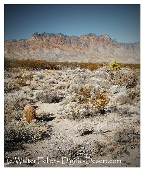
Eastern face of Providence Mountains