| Wilderness - MAP - Whipple Mountains < East Mojave Desert | Desert Gazette |
| top >> mojave << features - wildlife - places - region map - map/sat - roads & trails - wilderness - video - aerial - 360 - old west - communities - books - lodging - |
| route 66 - ghost towns - gold mines - parks & ... - joshua tree - death valley - mojave preserve - plants - native culture - history - natural features - geology - glossary - |
|
|
Whipple Mountains Wilderness SIZE: 77,520 acres LOCATION: San Bernardino County; 10 miles northwest of Parker, Arizona
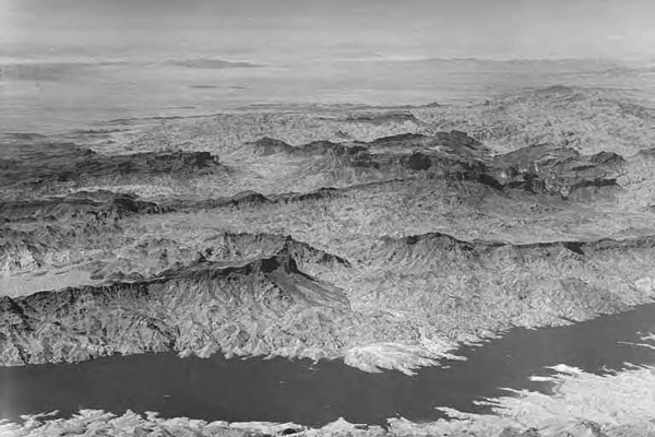
 NATURAL RESOURCES: The Whipple Mountains lie east to west across this wilderness. The western half of the range is created from pale green formations. A low angle fault separates the formation on the west from striking brick red volcanic formations to the east. The landscape is diverse, ranging from valley floors and washes to steep-walled canyons, domed peaks and eroded spires towering to 4,000 feet. Flowing westward from these colorful spires and domes are bajadas with isolated lava rock masses and red sandstone outcrops. Sonoran creosote bush scrub and the Sonoran thorn forest decorate the area. In addition, dense stands of palo verde, ironwood, smoke tree and cholla, saguaro, foxtail and Mojave prickly pear cacti all grow here. This unique array of vegetation support a variety of wildlife.
ACCESS: Access to the eastern boundary of the wilderness is by four-wheel drive vehicle on a powerline road. Start at Parker Dam on the Colorado River and go south on the California side to Black Meadow Landing Road (less than a mile). Take this paved road 6 miles to the dirt road that leads to Havasu Palms. Follow this route for 2.1 miles to the powerline road, which for the next 8 miles, forms the eastern boundary of the wilderness. Geomorphic Province : Mojave Desert Ecosection : Mojave Desert, Sonoran Desert Ecosubsection : Piute Valley - Sacramento Mountains, Cadiz - Vidal Valleys Native Culture : Mohave, Chemehuevi |
|
-.- |
| top >> mojave << features - wildlife - places - region map - map/sat - roads & trails - wilderness - video - aerial - 360 - old west - communities - books - lodging - |
| route 66 - ghost towns - gold mines - parks & ... - joshua tree - death valley - mojave preserve - plants - native culture - history - natural features - geology - glossary - |
|
Wrightwood Real Estate MOUNTAIN HOMES & CABINS Vacation Rentals & Homes for Sale |
Log Cabin Furnishings Lodgepole Pine Log Furniture Rustic Decor & Silhouette Metal Art |
Victorville - Hesperia ~ HOMES FOR SALE ~ New Life Financial Services Realty |
| Victorville - Hesperia - Apple Valley - *Adelanto - Baker - Barstow - *Lucerne Valley - Big Bear - Lake Arrowhead - Yucca Valley - Joshua Tree - Twentynine Palms - Palmdale - Lancaster - Mojave - Tehachapi - California City - *Boron - Ridgecrest - *Randsburg - Nipton - Shoshone - Tecopa - Death Valley Junction - Needles - Lone Pine - Big Pine - Bishop - Independence - Trona - |
|
Digital-Desert Abraxas Engineering privacy |
Copyright ©Walter Feller. All rights reserved. Respect U.S and international copyright statutes and our right to own and control our work - DO NOT LINK TO THESE IMAGES FROM WEB PAGES, FORUMS OR BLOGS - |
Desert Gazette |