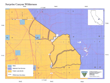
Surprise Canyon >> Map #62
Surprise Canyon Wilderness
SIZE: 29,180 acresLOCATION: Inyo County; 56 miles northeast of Ridgecrest, California and 27 miles northeast of Trona, California
NATURAL RESOURCES:
Small, alluvial slopes in the west gradually rise eastward into the jagged ridges and steep slopes of the western face of the Panamint Mountains. Deep canyons cut into the mountain range forming the interior of the wilderness. Elevations climb dramatically from 1,000 feet on the west side to more than 7,000 feet on the east and provide beautiful vistas of the Panamint Valley. Creosote bush scrub and desert holly dot the alluvial fans, while the rocky canyon walls support the endangered Panamint daisy. Cottonwood and willows grow in the canyons and pinyon and juniper on the higher slopes. Portions of Jail, Surprise and Happy Canyons and riparian vegetation highlight this wilderness. Most of Surprise Canyon has been designated as an Area of Critical Environmental Concern to protect wildlife, vegetation, historic and cultural resources. Wildlife species include desert bighorn sheep, and the indigenous Panamint alligator lizard and rattlesnake.
| GLOSSARY | > alluvial fan, canyon |
ACCESS: Access to this wilderness is via State Highway 178 through Panamint Valley and along Ballarat Road to Indian Ranch Road. Four-wheel drive routes provide access into jail, Surprise and Happy Canyons. Check road conditions before driving.
