Route 18
Big Pine to Furnace Creek
This long, little-traveled, adventurous route is the northwest Passage into Death Valley National Park, crossing two mountain ranges and linking two great north American deserts. Within the park it brings you to the colorful geology of Ubehebe Crater and The equally colorful history of Scottys Castle.What to expect: The partially paved road from Big Pine to Crankshaft Junction can be snowy in winter or washed out any time; the Big Pine Chamber of Commerce can usually tell you if its passable. Also call the Park for condition of roads within its boundaries. Fill your tank and check your spare at Big Pineno services are available until Scottys Castle. Intersections are wellmarked. A Park entrance station collects a small fee. The route ends in Death Valley, so plan an overnight stay.
Length: 105 miles one way.
Driving time: 4 hours one way.
Getting there: The route starts at Big Pine and goes east on Hwy.168 from its intersection with Highway 395 at the north end of town.
Along the route: Just after crossing the Owens River a plaque on the left marks the site of Zurich, a railroad station on the Carson & Colorado line. Traces of buildings can still be seen. A bit farther is the right turn onto paved, but rough, Death Valley Road. Check the sign for road closures.
The mountains ahead are called the Inyos from here south, and the Whites to the north. As you climb, look back for an overview of the forces that shaped Owens Valleythe steeply fault-tilted, glaciated Sierra, and basalt cinder cones on the valley floorjust before the road enters the Inyos. Unlike the granite Sierra, the result of magma cooled underground, the White/Inyo range is mostly ancient lakebeds, with fossil-rich layers of rock such as limestone and dolomite. About five miles farther the road passes through a narrow canyon where the layers have been wildly contorted by earthquake faults.
At about sixteen miles youll top the crest; use a low gear and save your brakes going down. Soon you leave the sagebrush-dominated Great Basin Desert and enter the Mojave Desert, where rangy creosote bushes and bizarrely-shaped Joshua trees prevail. At thirty miles the road descends into the north end of Eureka Valley. At the south end, visible from here, are the Eureka Dunessecond-tallest sand dunes in the United States. Pavement ends and there are about seven miles of dirt road eastward across the valley.
Just after pavement resumes is the turnoff to the dunes: 10 miles of rough dirt road, a long, bumpy optional side trip. If you do go be aware that this isolated island of sand, with its challenging conditions for life, has led to the evolution of plant and insect species found nowhere else. Here, as always, stay on established roads!
Our route continues on pavement and climbs up Hanging Rock Canyon into the Last Chance Range. After five miles pavement ends again after passing a private sulfur mine (entry is illegal). The road descends into Death Valley and veers south at Crankshaft Junction, marked by several rusted old crankshafts. After twenty miles is a right turn onto the three-mile paved road to Ubehebe Crater. This giant red and orange hole in the flank of Tin Mountain was formed by a huge steam explosion when magma rose to encounter groundwater. You can hike around its rim, or scramble to the bottom and laboriously climb back out.
Return to the main road, now paved, and continue southeast three miles to the left turn to Scottys Castle. Death Valley Scotty fooled Easterners into investing in an imaginary gold mine, including a millionaire Chicago couple who eventually befriended Scotty and let him continue the ruse that their vacation home was built with income from his secret mine. Tickets for tours are sold on the grounds. If you love old junk, pick up a Tie Canyon trail guide at the ticket booth and hike through the historic storage yard.
Back on the main road, proceed through the Park entrance station. (Fee required.) After 18 miles you may choose a quick side trip to Titus Canyon, with walls hundreds of feet high only 20 feet apart. Continuing along the main road brings views of colorfully striped mountains and vast sand dunes. At the T intersection with Highway 190 turn left toward Furnace Creek. Within 7 miles is a short spur road to the home of the Salt Creek pupfish, one of the amazing local species that have adapted to an incredible array of harsh desert conditions. Furnace Creek, which has a visitor center, food, lodging and camping, is the end of the route.
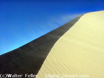
Near the top of Eureka Dunes
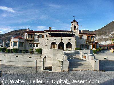
Scotty's Castle
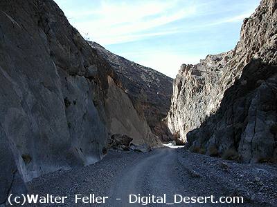
Titus Canyon