Furnace Creek Wash Area
Dantes View
FC5. Location/Access:(36o 13.582N, 116o 43.545W) Located at the end of the Dantes View paved road, 13.2 miles south of Highway 190 or 24 miles southeast of the Highway 190/Badwater Road junction. The actual GPS coordinates are a short hike north of the parking lot (1/3 mile) which affords a better view, especially to the north. The road is rarely closed by ice or snow.
Best Time: Early morning, all year but best in the winter.
Geology: Dantes view is one of four relatively accessible high points that offer truly amazing views of Death Valley
(see also Sites
GF1,
NP6
and
CM3). Of
the four, Dantes view is the most accessible and most popular.
After leaving the
area of the Billie Mine and
Ryan
(Site FC4), the road travels over Quaternary fan gravels and then through volcanic rocks
of the Miocene Greenwater formation which intertongues between the lower and upper units of the Furnace Creek formation
(Greene, 1997).
En route and near the viewpoint, most of the rocks are felsic tuffs and volcanic breccias. Near Dantes
view, these rocks form the upper plate of the Badwater Turtleback.
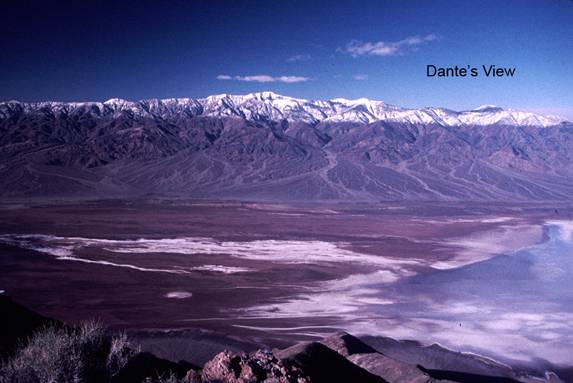
From Dantes View at approximately 5,500ft elevation,
one has a terrific view of the floor of Death Valley over one mile in elevation below you. Looking past the Black
Mountains metamorphic complex forming the cliffs below, one can see the
playa
surface near
Badwater. The
light areas of the playa are evaporates such as salt and borate while the dark areas are silts and clays washed down from the
surrounding mountains or brought in by the
Amargosa River
whose small delta is sometimes visible. Note that the east side
of Death Valley has
alluvial fans
while the west side is bordered by a large
bajada
draping down from the
Panamint Mountains.
Telescope Peak dominates the horizon to the west. Looking a little farther northwest, the high crest of the
Sierra Nevada
can be seen peeking over the
Inyo Range
beyond the
Panamints. Although one cannot see the exact lowest
point at
Badwater
because of the slope, one can see the highest and lowest areas in the 48 contiguous states at the same
time! When looking northward up the axis of Death Valley, the
Artists Palette
area,
Furnace Creek
and the
Cottonwood
and
Grapevine mountains are all visible. From the vantage point of the GPS site north of the parking area, there is also a
good view of the
Funeral Mountains
and the
Billie Mine/Ryan
area. To the east one can see the Spring Mountains which
lie just west of
Las Vegas. Southward,
especially if one walks to the point at the end of the trail leaving the parking
area, there is a good view towards Mormon Point and the southern reaches of the valley. The elevation at the parking
lot is 5,475ft and the elevation on the hill top at the GPS coordinates is 5,703ft.
Dante's View
Dante's View Geology
=-=