Mushroom Rock & Lake Manly Terrace
BW7. Location/Access:(36o 23.207N, 116o 51.092W) Located approximately 5.6 miles south of Furnace Creek just north of the exit of the one-way Artists Drive. Parking is best just south of the site and north of the junction if you are northbound as the parking area which was located at Mushroom Rock for many years has been removed.
Best Time: Morning, all year although the hike up to the Lake Manly terrace is very steep and should probably be avoided in mid-summer heat.
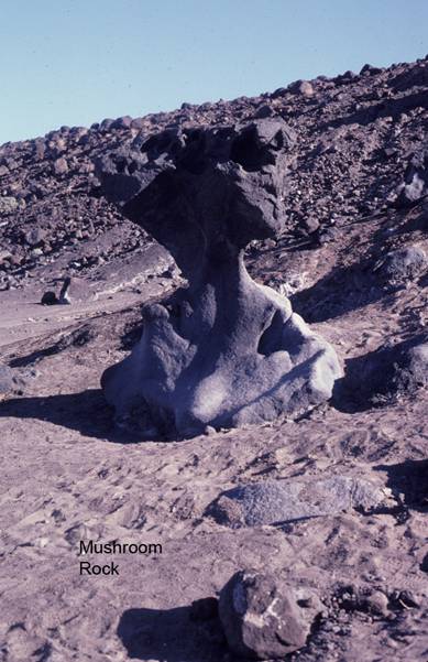
Geology: The origin of Mushroom Rock has been debated for many years. Generally, most people thought it was a ventifact as these are quite common on the low hill on the west side of the main highway across from the exit of the Artists Drive. However, as pointed out by Meek and Dorn (2000), and obvious to anyone standing there, there are no other ventifacts in the immediate vicinity. Thus more recent researchers have ascribed its origin to weathering either by salt expansion or other weathering processes. If you look carefully, you will notice that it has been repaired after vandals damaged it some years back. If you climb the hill directly behind (east) Mushroom Rock, you will ascend quite a few wave benches before you arrive at a rather broad mesa which is a large terrace built by shoreline processes of Pleistocene Lake Manly. These smaller benches you cross on the way up are quite obvious once you have reached the top. This is one of the two largest shoreline features created during the existence of Lake Manly (see Site CD3) and it would be interesting to know the exact elevation difference between the two to help to determine Quaternary uplift rate differences between the two sites. Using GPS, we have determined the elevation of this terrace to be 25 feet below sea level, plus or minus 4 feet (-25ft +/-4ft). If you look down below to the playa surface just northwest of Mushroom Rock, you will notice man-made scratching and lines of small piles on the playa surface. These are raking marks from when the playa was mined for borax. There is also a great view of the Panamint Range and its bajadas from this vantage point. Note that the gravels of the bajadas have about four distinct colors with the younger gravels being the lightest gray and the oldest being darker brown. Notice also that the lightest (youngest) gravels are within the washes indicating that the bajadas and alluvial fans in Death Valley are being eroded. This may be due to the relatively recent drop in base level due to the evaporation of Lake Manly. In any case, the major fan and bajada surfaces in Death Valley are generally inactive.
Death Valley
-
The predominant natural plant communities on fans are Desert-holly series and, higher up the fans, Creosote bush series. Desert-holly
series is replaced by Allscale series toward the southern end of the valley. Brittlebush series and White bursage series are common
in washes on the fans. ...
=-=