--
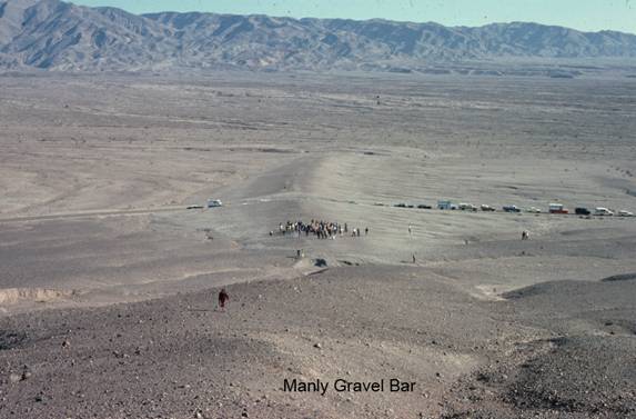
Manly Gravel Bar
CD3. Location/Access:(36o 36.852N; 116o 56.825W) This feature cuts directly across the Beatty Cut-Off road 1.8 miles north of CA 190.
Best Time: Afternoon, all year.
Geology: The fact that the road crews that built the paved road through here and cut directly through the gravel bar indicates that its geologic significance was not known at that time. Although it is regrettable that this geologic feature was damaged by road construction, there is a benefit in that one can now get a good cross-sectional look at the gravel deposit itself. The gravel bar was built by waves on the shoreline of Lake Manly at one of the later stands of the lake. This is likely because the gravel is very light in color and thus younger than the fan gravels upon which its sits which are darker, indicating more desert varnish and thus greater age (Miller and Wright, 2004). Warnke (2005) estimates the age of the bar, which is about 16 ft thick, to be about 153 Ka. The bar is about 1600 ft long and between 160 and 325 ft wide (Larson, et. al., 2007). Recent Paleontologic data (Forester, et. Al, 2005) suggests a high stand of lake Manly at 154.5 Ka at 143.2 m that may have persisted for nearly 5,000 years. A following high stand at about 121 Ka had a depth of 112 m. Looking at the road cut you will notice that the gravels are both graded and imbricated. Also, if you hike a little west along the crest of the gravel bar you will notice that the surface is composed of desert pavement: The surface has a cobblestone effect wherein surficial particles of sand and finer grains are not present either because they have been washed or blown away or clays have been blown or washed in, carried down by percolating rainwater and then due to shrink/swell have lifted the gravel particles to the surface. These two competing hypotheses for the origin of desert pavement each have their adherents. This bar has an elevation of about 150 feet. This is different from the most obvious high strandline at Shoreline Butte (Site SC1). It would be informative to have a comparison between this feature, Shoreline Butte and the terrace above Mushroom Rock (Site BW7). The elevation of the major terrace above Mushroom Rock is (-25ft) thus the apparent approximate difference is about 175ft. This is considerable and needs explaining. There is a second, less well-formed gravel bar parallel to the main one a few yards south, lying mostly on the east side of the highway. This is more obvious viewed from on top of the hill to the west. Death Valley actually has very few Pleistocene lake features when compared to many other Great Basin valleys. One could thus deduce that water filled this valley less frequently than others. Thus stream flow through the lake system from the Sierra Nevada must have been sporadic and/or the smaller amounts of local rainfall (then as now) were insufficient to maintain a large lake for long. The Amargosa River probably only regularly drained into Death Valley only towards the end of the Pleistocene (Butler, 1982) and obviously sporadically since.
=-=