Racetrack Playa
The Sliding Stones of Death ValleyRacetrack Playa lies in the remote northern part of Death Valley National Park. The site presents a striking geological enigma: stones that seem to move across the lake bed on their own, leaving long, winding trails etched into the sunbaked surface. These mysterious sliding stones have fascinated both casual observers and scientists for generations. As a result, Racetrack Playa stands among the world's most intriguing geological mysteries. This essay will explore the playa's physical features, examine the history and study of the sliding stones, and discuss the unique natural conditions that enable the phenomenon.
The playa lies in a desert basin between the Cottonwood Mountains and the Last Chance Range. For most of the year, it is a dry, hard clay expanse. Rare winter storms send mountain runoff across the basin. This creates a shallow lake, just inches deep. As the water evaporates under the desert sun, the mud contracts into polygonal cracks. These cracks give the playa its distinctive surface.
Rocks of all sizes, from pebbles to boulders over 300 kilograms (700 pounds), lie scattered across the lake bed (U.S. Geological Survey, 2003). Most of these rocks were loosened from the surrounding mountain slopes by weathering. Over time, they tumbled onto the playa. Many eventually left long grooves behind (Norris et al., 2000, pp. 253-265).
For decades, no one saw the rocks move. Some trails were straight. Others curved, crossed, or changed direction. Theories varied, ranging from wind to earthquakes to magnetism to the supernatural. Scientists thought wind might be the cause, but the largest rocks seemed too heavy for wind alone to move on dry ground.
The mystery was resolved in 2014. New evidence clarified and expanded earlier wind-driven theories. Researchers documented rocks moving during rare weather. Wind played a role, but other factors mattered, too. On cold nights, water formed a thin ice layer. As the morning warmed the playa, the ice fractured. Ice panels, pushed by gentle winds, slowly moved rocks across saturated mud. The slick surface reduced friction, letting even the largest stones move under light wind. This resolved contradictions in earlier hypotheses (Norris et al., 2014).
Rocks move slowly, sometimes only a few feet per event. This makes movement nearly impossible to watch without close study. Over the years, repeated shifts create trails hundreds of feet long. Weather and floods eventually erase them (Norris et al., 2014).
Today, the moving stones are no longer an unsolved mystery. Still, they remain one of Death Valley's most fascinating wonders. The rare combination of shallow water, freezing temperatures, floating ice, gentle winds, and a flat playa is needed. This makes rock movement infrequent (Norris et al., 2014).
Visitors at Racetrack Playa see the same striking landscape that has sparked curiosity for generations. There is a silent lake bed, distant mountains, and rocks stationed at the ends of long trails. While science has revealed the mechanism behind the moving stones, this phenomenon remains a reminder: nature’s extraordinary events often arise from basic physical interactions. Beyond local importance, Racetrack Playa shows how persistent study and investigation can solve mysteries and expand scientific knowledge. The study encourages scientists to challenge assumptions, develop new methods, and apply findings in different places. Even well-studied processes may offer new insights. These may have implications beyond their immediate setting, showing the dynamic nature of scientific understanding.
Also see:
Playa/Dry Lake Formation
A playa is a dry, vegetation-free, flat area at the lowest part of an undrained desert basin...Lost Lakes of Death Valley
The lakes dissappeared approximately 10,000 years ago when ...Natural Formations
Photos of Mojave Desert Dry Lakes
In desert basins, where rivers merge but do not drain...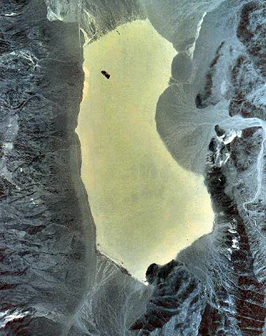
Satellite image of Racetrack Playa. The Last Chance range is on the left, Cottonwood mountains to the right of the light-colored playa surface.
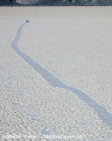
A sliding rock and its trail cut across Racetrack Playa.
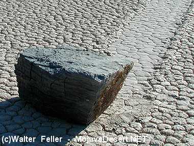
Note the shallow furrow and rounded, levee-like ridges that form the "trail."