Bitter Springs

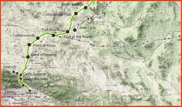
Bitter Springs is one of the working water stops of the central Mojave: not a town, not a monument, but a spring that travelers had to plan around. It lies in the region that is now Fort Irwin, and for wagon-era parties and pack travel alike it functioned as a watering and grazing place on the long, hard reach between the Amargosa side and the Mojave River.
In the Old Spanish Trail era, Bitter Springs belongs to the practical chain of named waters that made the Santa FeLos Angeles trade corridor possible across the western Mojave. In the later overlap era, it appears again on the Mormon Road / Los AngelesSalt Lake Road line, because the map still obeyed the same rule: in this country, water decides the days march.
That overlap is easy to misunderstand. The Old Spanish Trail was primarily a pack-train trade system, while the Salt Lake Road was a wagon-and-freight road that developed later for different traffic. But where a spring sits at the right interval, both systems reuse it. Bitter Springs is one of those interval points.
By 18591860, the corridor also entered a security phase. Attacks along the wagon road made certain waterholes dangerous, and Bitter Springs is repeatedly cited in accounts of trouble on the Mormon wagon road during that period. In that setting, Bitter Springs reads less like a scenic stop and more like a vulnerable node that needed protection simply because everyone had to come there for water.
Today the sites historic importance is preserved mostly in its name and in the old route logic it represents: a spring that held a route together. Sheldon Stoddard
At Bitter Springs Lyman, Rich, Hopkins, Rollins and Captain Hunt started on ahead of the company on horseback, Stoddard accompanying them with a mule ...
Some Gang Members Elude Capture
Al Williams was the brother of Thomas Williams, the merchant killed by Indians and buried at Bitter Springs the year prior. It is somewhat ironic that Al Williams ...
A History of Zzyzx: 1860 - 1870 Army Outpost
The redoubt erected at Soda Springs is about the same size as that erected at Bitter Spring: it is called Hancock's Redoubt. (Named in honor of Army Quarter ...
Alvord Mine
This company owned the water rights for Paradise Springs, 9 miles north of the ... Wagon trail winds north and east from Alvord Summit toward Bitter Spring on ...
Bitter Springs
The Evolution of Bitter Springs - Fort Irwin Historical Review By Neil C. Morrison Museum Director NTC & 11TH ACR Museum ...
First Visitors to Bitter Springs
Father Francisco Garces. The first recorded contact with the local Native Americans was through Father Francisco Garces, ...
History in the Mojave Preserve
In 1860, two whites were murdered at Bitter Springs, on the Mormon wagon road, and the attacks were blamed on the "Pah-Utes," though contemporaries and ...
Man Dies at Lane's of Arrow Wounds
"Mr. Williams," the Los Angeles Star reported, "was buried at Bitter Springs, and Mr. Jackman was brought to Lane's ranch on the Mojave, where he receives ...
Mojave Desert Geomorphic Province
Goldstone Fault Blackwater Fault Bitter Springs Fault - Bicycle Lake Fault Gravel Hills - Harper Fault Zone Harper Lake Fault Lockhart and North Lockhart Faults
Vanyume Indians
First Inhabitants of Bitter Springs They were referred to by European travelers as Beneme, Vanyume, Paiute (Pah-Utah, Pai-Ute, Piute) and Serrano. They lived ...