Vincent Gap
General InformationVincent Gap has a large trailhead parking lot near the eastern end of the San Gabriel Mountains, 50 miles from I-210 in La Cañada and five miles west of Big Pines along SR2, the Angeles Crest Highway. Drainage on the north slope goes to the Big Rock Creek, thence to the Mojave Desert and from the south slope to the East Fork of the San Gabriel River.
Vincent Gap is named for Charles Tom Vincent, also known as Charles Vincent Dougherty, founder of the Bighorn Mine, hunter and hermit who lived nearby from 1870s to 1920s (The San Gabriels by John Robinson, page 26).
The Gap is the 6,565' saddle in the San Gabriel Mountains between the coastal and the desert basins on the south and north, respectively, and between Mt. Baden-Powell, 9,399' and Blue Ridge, 7,560' on the west and east. The Angeles Crest Highway crosses the Punchbowl Fault here. The trace is seen as the contact zone between the bright red sedimentary formation and the bluish gray granitic one.
The elevation is variously given as 6,565' on the highway sign and 6,593' on the GNIS web site and topo sheet.
Access
Map: Mt. Islip Region (VG marks the location, in the left center of the map)
See also: USGS 7.5' x 7.5' Map: Crystal Lake (34° 22' 25" N, 117° 45' 05" W)
By Car: From Interstate 210, go northeast on Angeles Crest Highway, State Route 2, 50 miles about one hour 20 minutes driving time to mile marker 74.8. Also, two truck trails (dirt roads for high clearance vehicles) meet SR2 here; one from Big Rock Creek (4N11) and one from Blue Ridge / Pinyon Ridge. Forest Adventure Pass is needed for parking.
By Trail: East or west from the Pacific Crest Trail (PCT); north from the Manzanita Trail which is a section of the High Desert National Recreation Trail; west from part of Silver Moccasin Trail from Mt. Baden-Powell, south from Prairie Fork through Sheep Mountain Wilderness, and south from Bighorn Mine.
Season: Open May to November or whenever SR2 is not closed by snow.
Source: J. Strong & T. Chester
Hiking Trails
Vincent Gap to Mt Baden-Powell
Vincent Gap to Prairie Fork
|
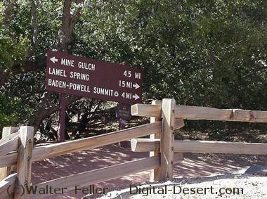 Sign at trailhead
 Vincent Gap